Category:Sandford, Blundellsands
Jump to navigation
Jump to search
| Object location | | View all coordinates using: OpenStreetMap |
|---|
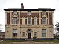
house in Sefton, Merseyside, UK  | |||||
| Upload media | |||||
| Instance of | |||||
|---|---|---|---|---|---|
| Location | Sefton, Merseyside, North West England, England | ||||
| Heritage designation |
| ||||
 | |||||
Grade II listed late 19th century house in Blundellsands, Sefton, Merseyside.
Media in category "Sandford, Blundellsands"
The following 3 files are in this category, out of 3 total.
-
 Sandford, Blundellsands 1.jpg 4,538 × 3,398; 18.3 MB
-
 Sandford, Blundellsands 2.jpg 4,951 × 3,274; 19.91 MB
-
 Sandford, Blundellsands 3.jpg 4,058 × 3,001; 13.15 MB

