Category:Sanborn maps of the Bronx published in 1900, V. 13
Jump to navigation
Jump to search
Maps from: Insurance Maps of The City of New York. Volume 13. (New York: Sanborn–Perris Map Co., Limited; 1900), comprising 57 maps (plates) plus title page, street index (missing from this category), and two-page volume key.
Online at The New York Public Library Digital Collections website, Atlas 51. Vol. 13, 1900.
Subcategories
This category has only the following subcategory.
Media in category "Sanborn maps of the Bronx published in 1900, V. 13"
The following 60 files are in this category, out of 60 total.
-

-
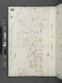
 Key NYPL2002785.tiff 6,669 × 8,900, 2 pages; 169.87 MB
-
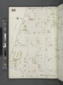
 Key continued NYPL2002786.tiff 6,723 × 8,972, 2 pages; 172.63 MB
-
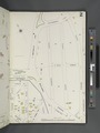
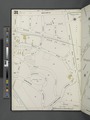
 Bronx, V. 13, Plate No. 1 (Map bounded by E. 176th St., Aqueduct Ave., Washington Bridge, Harlem River) NYPL2002787.tiff 6,659 × 8,887, 2 pages; 169.37 MB
-
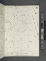
 Bronx, V. 13, Plate No. 2 (Map bounded by Featherbed Lane, Marcher Ave., Boscobel Ave., Washington Bridge) NYPL2002788.tiff 6,705 × 8,948, 2 pages; 171.71 MB
-
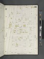
 Bronx, V. 13, Plate No. 3 (Map bounded by Belmont St., Jerome Ave., E. 170th St., Marcher Ave.) NYPL2002789.tiff 6,659 × 8,887, 2 pages; 169.37 MB
-
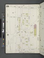
 Bronx, V. 13, Plate No. 4 (Map bounded by Belmont St., Grand Blvd., E. 170th St., Jerome Ave.) NYPL2002790.tiff 6,708 × 8,952, 2 pages; 171.87 MB
-
 Bronx, V. 13, Plate No. 5 (Map bounded by E. 176th St., Grand Ave., Featherbed Lane) NYPL2002791.tiff 6,637 × 8,858, 2 pages; 168.26 MB
-
 Bronx, V. 13, Plate No. 6 (Map bounded by E. 176th St., E. 175th St., Grand Blvd., Belmont St., Inwood Ave.) NYPL2002792.tiff 6,708 × 8,952, 2 pages; 171.87 MB
-
 Bronx, V. 13, Plate No. 7 (Map bounded by W. 177th St., Undercliff Ave., E. 176th St., Harlem River) NYPL2002793.tiff 6,646 × 8,869, 2 pages; 168.7 MB
-
 Bronx, V. 13, Plate No. 8 (Map bounded by Harlem River, Sedgwick Ave., E. 177th St.) NYPL2002794.tiff 6,708 × 8,952, 2 pages; 171.87 MB
-
 Bronx, V. 13, Plate No. 9 (Map bounded by Burnside Ave., Aqueduct Ave., E. 176th St., Underliff Ave.) NYPL2002795.tiff 6,578 × 8,778, 2 pages; 165.26 MB
-
 Bronx, V. 13, Plate No. 10 (Map bounded by Jerome Ave., E. 176th St., Aqueduct Ave.) NYPL2002796.tiff 6,697 × 8,937, 2 pages; 171.3 MB
-
 Bronx, V. 13, Plate No. 11 (Map bounded by Tremont Ave., Grand Blvd., E. 175th St., Jerome Ave.) NYPL2002797.tiff 6,626 × 8,842, 2 pages; 167.68 MB
-
 Bronx, V. 13, Plate No. 12 (Map bounded by E. 181st St., Grand Blvd., Tremont Ave., Jerome Ave.) NYPL2002798.tiff 6,708 × 8,952, 2 pages; 171.87 MB
-
 Bronx, V. 13, Plate No. 13 (Map bounded by E. 181st St., Jerome Ave., Tremont Ave., Aqueduct Ave.) NYPL2002799.tiff 6,626 × 8,842, 2 pages; 167.68 MB
-
 Bronx, V. 13, Plate No. 14 (Map bounded by E. 184th St., Jerome Ave., E. 181st St., Aqueduct Ave.) NYPL2002800.tiff 6,708 × 8,952, 2 pages; 171.87 MB
-
 Bronx, V. 13, Plate No. 15 (Map bounded by Cedar Ave., E. 180th St., Aqueduct Ave., Burnside Ave.) NYPL2002801.tiff 6,626 × 8,842, 2 pages; 167.68 MB
-
 Bronx, V. 13, Plate No. 16 (Map bounded by Cedar Ave., E. 181st St., Aqueduct Ave., E. 180th St.) NYPL2002802.tiff 6,732 × 8,983, 2 pages; 173.08 MB
-
 Bronx, V. 13, Plate No. 17 (Map bounded by Cedar Ave., Aqueduct Ave., E. 181st St.) NYPL2002803.tiff 6,635 × 8,854, 2 pages; 168.14 MB
-
 Bronx, V. 13, Plate No. 18 (Map bounded by Harlem River, Aqueduct Ave.) NYPL2002804.tiff 6,725 × 8,975, 2 pages; 172.74 MB
-
 Bronx, V. 13, Plate No. 19 (Map bounded by E. 183rd St., Grand blvd., E. 180th St., Jerome Ave.) NYPL2002805.tiff 6,656 × 8,883, 2 pages; 169.22 MB
-
 Bronx, V. 13, Plate No. 20 (Map bounded by E. 189th St., Grand Blvd., E. 183rd St., Jerome Ave.) NYPL2002806.tiff 6,725 × 8,975, 2 pages; 172.74 MB
-
 Bronx, V. 13, Plate No. 21 (Map bounded by Jerome Ave., Tiebout Ave., E. 189thSt.) NYPL2002807.tiff 6,581 × 8,782, 2 pages; 165.41 MB
-
 Bronx, V. 13, Plate No. 22 (Map bounded by Jerome Ave., Kingsbridge Rd., Briggs Ave.) NYPL2002808.tiff 6,720 × 8,968, 2 pages; 172.48 MB
-
 Bronx, V. 13, Plate No. 23 (Map bounded by E. 190thSt., Jerome Ave., E. 184th St., Aqueduct Ave.) NYPL2002809.tiff 6,640 × 8,861, 2 pages; 168.4 MB
-
 Bronx, V. 13, Plate No. 24 (Map bounded by Kingsbridge Rd., Jerome Ave., E. 190th St., Aqueduct Ave.) NYPL2002810.tiff 6,720 × 8,968, 2 pages; 172.48 MB
-
 Bronx, V. 13, Plate No. 25 (Map bounded by Fordham Rd., Harlem River) NYPL2002811.tiff 6,640 × 8,861, 2 pages; 168.4 MB
-
 Bronx, V. 13, Plate No. 26 (Map bounded by Kingsbridge Rd., Aqueduct Ave., E. 188thSt., Harlem River) NYPL2002812.tiff 6,720 × 8,968, 2 pages; 172.48 MB
-
 Bronx, V. 13, Plate No. 27 (Map bounded by E. 230th St., Nathalie Ave., Spuyten Duyvil Creek) NYPL2002813.tiff 6,689 × 8,927, 2 pages; 170.9 MB
-
 Bronx, V. 13, Plate No. 28 (Map bounded by Renervoir Ave., Kingsbridge Rd., Nathalie Ave.) NYPL2002814.tiff 6,704 × 8,947, 2 pages; 171.67 MB
-
 Bronx, V. 13, Plate No. 29 (Map bounded by Broadway, Sedgwick Ave., E. 230th St.) NYPL2002815.tiff 6,689 × 8,927, 2 pages; 170.9 MB
-
 Bronx, V. 13, Plate No. 30 (Map bounded by Broadway, E. 238th St., Sedgwick Ave.) NYPL2002816.tiff 6,704 × 8,947, 2 pages; 171.67 MB
-
 Bronx, V. 13, Plate No. 31 (Map bounded by Broadway, Van Cortlandt Ave., E. 238thSt.) NYPL2002817.tiff 6,655 × 8,882, 2 pages; 169.18 MB
-
 Bronx, V. 13, Plate No. 32 (Map bounded by Van Cortlandt Ave., Jerome Ave.) NYPL2002818.tiff 6,723 × 8,972, 2 pages; 172.63 MB
-
 Bronx, V. 13, Plate No. 33 (Map bounded by E. 194th St., Park Ave., E. 189th St., Tiebout Ave.) NYPL2002819.tiff 6,655 × 8,882, 2 pages; 169.18 MB
-
 Bronx, V. 13, Plate No. 34 (Map bounded by E. 198th St., Webster Ave., E. 194th St., Bainbridge Ave.) NYPL2002820.tiff 6,723 × 8,972, 2 pages; 172.63 MB
-
 Bronx, V. 13, Plate No. 35 (Map bounded by E. 198th St., Grand Blvd., Kingsbridge Rd., Jerome Ave.) NYPL2002821.tiff 6,664 × 8,893, 2 pages; 169.61 MB
-
 Bronx, V. 13, Plate No. 36 (Map bounded by E. 198thSt., Bainbridge Ave., Grand Blvd.) NYPL2002822.tiff 6,712 × 8,957, 2 pages; 172.06 MB
-
 Bronx, V. 13, Plate No. 37 (Map bounded by Jerome Ave., E. 200th St., Briggs Ave., E. 198th St.) NYPL2002823.tiff 6,664 × 8,893, 2 pages; 169.61 MB
-
 Bronx, V. 13, Plate No. 38 (Map bounded by Briggs Ave., E. 200th St., Webster Ave., E. 198th St.) NYPL2002824.tiff 6,712 × 8,957, 2 pages; 172.06 MB
-
 Bronx, V. 13, Plate No. 39 (Map bounded by Briggs Ave., Mosholu Parkway South, Webster Ave., E. 200th St.) NYPL2002825.tiff 6,633 × 8,852, 2 pages; 168.05 MB
-
 Bronx, V. 13, Plate No. 40 (Map bounded by Bainbridge Ave., Woodlawn Rd., Bronx Park, Mosholu Parkway) NYPL2002826.tiff 6,723 × 8,972, 2 pages; 172.63 MB
-
 Bronx, V. 13, Plate No. 41 (Map bounded by Jerome Ave., Briggs Ave., E. 200th St.) NYPL2002827.tiff 6,664 × 8,893, 2 pages; 169.61 MB
-
 Bronx, V. 13, Plate No. 42 (Map bounded by Jerome Ave., Van Cortlandt Ave., Mosholu Parkway, E. 203rd St.) NYPL2002828.tiff 6,723 × 8,972, 2 pages; 172.63 MB
-
 Bronx, V. 13, Plate No. 43 (Map bounded by Gun Hill Rd., Steuben Ave., Van C'tlandt Ave., Jerome Ave.) NYPL2002829.tiff 6,664 × 8,893, 2 pages; 169.61 MB
-
 Bronx, V. 13, Plate No. 44 (Map bounded by Jerome Ave., Woodlawn Rd., E. 211th St., Gun Hill Rd.) NYPL2002830.tiff 6,723 × 8,972, 2 pages; 172.63 MB
-
 Bronx, V. 13, Plate No. 45 (Map bounded by Mosholu Parkway, Hull Ave., Woodlawn Rd.) NYPL2002831.tiff 6,664 × 8,893, 2 pages; 169.61 MB
-
 Bronx, V. 13, Plate No. 46 (Map bounded by Steuben Ave., Gun Hill Rd., Hull Ave.) NYPL2002832.tiff 6,723 × 8,972, 2 pages; 172.63 MB
-
 Bronx, V. 13, Plate No. 47 (Map bounded by E. 207th St., Bronx Park, Woodlawn Rd., hull Ave.) NYPL2002833.tiff 6,664 × 8,893, 2 pages; 169.61 MB
-
 Bronx, V. 13, Plate No. 48 (Map bounded by Gun hill Rd., Bronx River, E. 207th St., Hull Ave.) NYPL2002834.tiff 6,723 × 8,972, 2 pages; 172.63 MB
-
 Bronx, V. 13, Plate No. 49 (Map bounded by E. 211th St., Bronx River, Gun Hill Rd.) NYPL2002835.tiff 6,636 × 8,856, 2 pages; 168.2 MB
-
 Bronx, V. 13, Plate No. 50 (Map bounded by E. 233rd St., Webster Ave.) NYPL2002836.tiff 6,698 × 8,939, 2 pages; 171.36 MB
-
 Bronx, V. 13, Plate No. 51 (Map bounded by E. 233rd St., Napier Ave., E. 233rd St., Jerome Ave.) NYPL2002837.tiff 6,648 × 8,871, 2 pages; 168.79 MB
-
 Bronx, V. 13, Plate No. 52 (Map bounded by Mount Vernon Ave., Kepler Ave., E. 233rd St., Napier Ave.) NYPL2002838.tiff 6,698 × 8,939, 2 pages; 171.36 MB
-
 Bronx, V. 13, Plate No. 53 (Map bounded by Kepler Ave., E. 237th St., Marthe Ave., Verio Ave., E. 233rd St.) NYPL2002839.tiff 6,648 × 8,871, 2 pages; 168.79 MB
-
 Bronx, V. 13, Plate No. 54 (Map bounded by Kepler Ave., Mount Vernon Ave., Martha Ave., E. 237th St.) NYPL2002840.tiff 6,698 × 8,939, 2 pages; 171.36 MB
-
 Bronx, V. 13, Plate No. 55 (Map bounded by E. 235th St., Bronx River, E. 233rd St., Verio Ave.) NYPL2002841.tiff 6,648 × 8,871, 2 pages; 168.79 MB
-
 Bronx, V. 13, Plate No. 56 (Map bounded by E. 241st St., McLean Ave., Webster Ave., E. 235th St., Martha Ave.) NYPL2002842.tiff 6,673 × 8,905, 2 pages; 170.07 MB
-
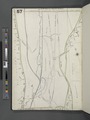 Bronx, V. 13, Plate No. 57 (Map bounded by Broadway, Van Cortlandt Park South, Jerome Ave.) NYPL2002843.tiff 6,618 × 8,832, 2 pages; 167.29 MB