Category:Sanborn maps of the Bronx published in 1900, V. 12
Jump to navigation
Jump to search
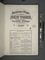
Maps from: Insurance Maps of the City of New York. Volume 12. (New York: Sanborn–Perris Map Co., Limited; 1900), comprising 26 maps (plates) of the Bronx numbered 28–53 plus title page, two-page volume key, street index (TIF version missing from this category), and 27 maps of Manhattan.
Online at The New York Public Library Digital Collections website, Atlas 128. Vol. 12, 1900.
Subcategories
This category has only the following subcategory.
Media in category "Sanborn maps of the Bronx published in 1900, V. 12"
The following 28 files are in this category, out of 28 total.
-
-
 Key continued NYPL2001862.tiff 6,702 × 8,944, 2 pages; 171.56 MB
-
 Bronx, V. 12, Plate No. 28 (Map bounded by Johnson Ave., W. 232nd St., Broadway, W. 230th St.) NYPL2001890.tiff 6,717 × 8,964, 2 pages; 172.33 MB
-
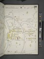
 Bronx, V. 12, Plate No. 29 (Map bounded by Harlem River, Spuyten Duyvil Creek) NYPL2001891.tiff 6,649 × 8,873, 2 pages; 168.85 MB
-
 Bronx, V. 12, Plate No. 30 (Map bounded by Independence Ave., W. 230th St., Spuyten Duyvil Creek) NYPL2001892.tiff 6,725 × 8,975, 2 pages; 172.74 MB
-
 Bronx, V. 12, Plate No. 31 (Map bounded by Viaduct, Harlem River, Hudson River) NYPL2001893.tiff 6,582 × 8,784, 2 pages; 165.47 MB
-
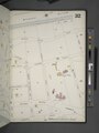 Bronx, V. 12, Plate No. 32 (Map bounded by Hudson River, W. 236th St., Fairfield Ave., W. 230th St.) NYPL2001894.tiff 6,725 × 8,975, 2 pages; 172.74 MB
-
 Bronx, V. 12, Plate No. 33 (Map bounded by W. 236th St., Oxford Ave., W. 230th St., Spuyten Duyvil Parkway) NYPL2001895.tiff 6,642 × 8,863, 2 pages; 168.48 MB
-
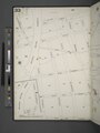
 Bronx, V. 12, Plate No. 34 (Map bounded by Oxford Ave., W. 236th St., Broadway, W. 232nd St.) NYPL2001896.tiff 6,725 × 8,975, 2 pages; 172.74 MB
-
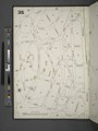 Bronx, V. 12, Plate No. 35 (Map bounded by W. 244th St., Broadway, W. 236th St., Greystone Ave.) NYPL2001897.tiff 6,608 × 8,819, 2 pages; 166.79 MB
-
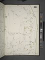 Bronx, V. 12, Plate No. 36 (Map bounded by Broadway, W. 244th St., Waldo Ave.) NYPL2001898.tiff 6,706 × 8,950, 2 pages; 171.78 MB
-
 Bronx, V. 12, Plate No. 37 (Map bounded by Half Moon Pl., Spuyten Duyvil Parkway, Delafield Ave.) NYPL2001899.tiff 6,608 × 8,819, 2 pages; 166.79 MB
-
 Bronx, V. 12, Plate No. 38 (Map bounded by Greystone Ave., W. 236th St., Netherland Ave.) NYPL2001900.tiff 6,706 × 8,950, 2 pages; 171.78 MB
-
 Bronx, V. 12, Plate No. 39 (Map bounded by Half Moon Pl., Independence Ave., W. 235th St., Spuyten Duyvil Rd.) NYPL2001901.tiff 6,599 × 8,806, 2 pages; 166.32 MB
-
 Bronx, V. 12, Plate No. 40 (Map bounded by W. 250th St., Arlington Ave., Hudson River) NYPL2001902.tiff 6,706 × 8,950, 2 pages; 171.78 MB
-
 Bronx, V. 12, Plate No. 41 (Map bounded by W. 250th St., Leibnitz Ave., Arlington Ave.) NYPL2001903.tiff 6,587 × 8,791, 2 pages; 165.73 MB
-
 Bronx, V. 12, Plate No. 42 (Map bounded by W. 250th St., Tibbett Ave., W. 244th St.) NYPL2001904.tiff 6,706 × 8,950, 2 pages; 171.78 MB
-
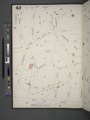 Bronx, V. 12, Plate No. 43 (Map bounded by W. 255th St., Fieldston Rd., W. 250th St., Avenue Von Humboldt) NYPL2001905.tiff 6,568 × 8,765, 2 pages; 164.77 MB
-
 Bronx, V. 12, Plate No. 44 (Map bounded by W. 254th St., Broadway, W. 250th St.) NYPL2001906.tiff 6,710 × 8,954, 2 pages; 171.96 MB
-
 Bronx, V. 12, Plate No. 45 (Map bounded by Independence Ave., Hudson River) NYPL2001907.tiff 6,665 × 8,894, 2 pages; 169.66 MB
-
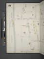
 Bronx, V. 12, Plate No. 46 (Map bounded by W. 256th St., W. 250th St., Independence Ave.) NYPL2001908.tiff 6,710 × 8,954, 2 pages; 171.96 MB
-
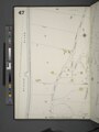 Bronx, V. 12, Plate No. 47 (Map bounded by Independence Ave., Hudson River) NYPL2001909.tiff 6,669 × 8,900, 2 pages; 169.87 MB
-
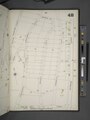 Bronx, V. 12, Plate No. 48 (Map bounded by Arlington Ave., Riverdale Ave., W. 256th St., Independence Ave.) NYPL2001910.tiff 6,728 × 8,978, 2 pages; 172.88 MB
-
 Bronx, V. 12, Plate No. 49 (Map bounded by W. 260th St., Fieldston Rd., W. 255th St., Riverdale Ave.) NYPL2001911.tiff 6,669 × 8,900, 2 pages; 169.87 MB
-
 Bronx, V. 12, Plate No. 50 (Map bounded by W. 259th St., Broadway, W. 254th St., Fieldston Rd.) NYPL2001912.tiff 6,728 × 8,978, 2 pages; 172.88 MB
-
 Bronx, V. 12, Plate No. 51 (Map bounded by W. 262nd St., Fieldston Rd., W. 260th St., Riverdale Ave.) NYPL2001913.tiff 6,661 × 8,890, 2 pages; 169.48 MB
-
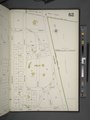 Bronx, V. 12, Plate No. 52 (Map bounded by W. 262nd St., Broadway, W. 259th St., Fieldston Rd.) NYPL2001914.tiff 6,703 × 8,946, 2 pages; 171.62 MB
-
 Bronx, V. 12, Plate No. 53 (Map bounded by Hudson River, Riverdale Ave., Arlington Ave.) NYPL2001915.tiff 6,661 × 8,890, 2 pages; 169.48 MB