Category:Sanborn maps of Manhattan published in 1895
Jump to navigation
Jump to search
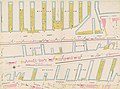
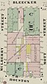
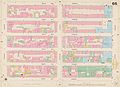
Maps from: Insurance Maps of the City of New York Surveyed and Published by Sanborn–Perris Map Co., Limited. Volume 3. (New York: 1895), comprising 20 maps (double-page plates) plus title page, street index, and volume key. The plates are numbered 49–66 and 66½; one plate is not numbered (Hudson River piers). Plates 49–53 are each scanned in two images, left half and right half, in addition to the whole. Plate 57 is only scanned in two images, left half and right half.
Source: The New York Public Library Digital Collections website, Atlas 42.53. Vol. 3, 1895.
Subcategories
This category has only the following subcategory.
Media in category "Sanborn maps of Manhattan published in 1895"
The following 38 files are in this category, out of 38 total.
-
 Sanborn Manhattan V. 3 title page publ. 1895.jpg 3,878 × 7,333; 4.79 MB
-
 Sanborn Manhattan V. 3 street index publ. 1895.jpg 4,867 × 6,419; 6.89 MB
-
 Sanborn Manhattan V. 3 volume key publ. 1895.jpg 5,043 × 7,238; 6.15 MB
-
 Sanborn Manhattan V. 3 Hudson River piers publ. 1895.jpg 8,024 × 5,966; 5.98 MB
-
 Sanborn Manhattan V. 3 Plate 49 (left half) publ. 1895.jpg 3,986 × 5,960; 3.66 MB
-
 Sanborn Manhattan V. 3 Plate 49 (right half) publ. 1895.jpg 4,074 × 5,808; 3.63 MB
-
-
 Sanborn Manhattan V. 3 Plate 49 (whole) publ. 1895.jpg 8,195 × 5,991; 8.19 MB
-
 Sanborn Manhattan V. 3 Plate 50 (left half) publ. 1895.jpg 4,001 × 5,991; 3.74 MB
-
 Sanborn Manhattan V. 3 Plate 50 (right half) publ. 1895.jpg 3,943 × 5,937; 3.52 MB
-
 Sanborn Manhattan V. 3 Plate 50 (whole) publ. 1895.jpg 8,019 × 6,002; 8.23 MB
-
 Sanborn Manhattan V. 3 Plate 51 (left half) publ. 1895.jpg 4,015 × 5,983; 3.52 MB
-
 Sanborn Manhattan V. 3 Plate 51 (right half) publ. 1895.jpg 4,048 × 5,834; 3.53 MB
-
 Sanborn Manhattan V. 3 Plate 51 (whole) publ. 1895.jpg 8,145 × 5,989; 7.81 MB
-
 Sanborn Manhattan V. 3 Plate 52 (left half) publ. 1895.jpg 3,993 × 5,842; 3.36 MB
-
 Sanborn Manhattan V. 3 Plate 52 (right half) publ. 1895.jpg 4,048 × 5,850; 3.35 MB
-
 Sanborn Manhattan V. 3 Plate 52 (whole) publ. 1895.jpg 8,153 × 5,898; 7.38 MB
-
 Sanborn Manhattan V. 3 Plate 53 (left half) publ. 1895.jpg 4,011 × 5,883; 3.34 MB
-
 Sanborn Manhattan V. 3 Plate 53 (right half) publ. 1895.jpg 4,062 × 5,958; 3.26 MB
-
 Sanborn Manhattan V. 3 Plate 53 (whole) publ. 1895.jpg 8,150 × 5,950; 7.64 MB
-
 Sanborn Manhattan V. 3 Plate 54 publ. 1895.jpg 8,122 × 5,988; 6.34 MB
-
 Sanborn Manhattan V. 3 Plate 55 publ. 1895.jpg 8,162 × 5,975; 7.01 MB
-

-
 Sanborn Manhattan V. 3 Plate 56 publ. 1895.jpg 8,154 × 5,949; 7.2 MB
-
 Sanborn Manhattan V. 3 Plate 57 (left half) publ. 1895.jpg 4,776 × 7,319; 5 MB
-
 Sanborn Manhattan V. 3 Plate 57 (right half) publ. 1895.jpg 5,138 × 7,204; 4.05 MB
-
 Sanborn Manhattan V. 3 Plate 58 publ. 1895.jpg 8,066 × 5,954; 6.84 MB
-
 Continental Brewery, Sanborn Manhattan V. 3 Plate 59 publ. 1895 (cropped).jpg 1,155 × 1,130; 224 KB
-
 Sanborn Manhattan V. 3 Plate 59 publ. 1895.jpg 8,170 × 5,890; 7.2 MB
-
 Sanborn Manhattan V. 3 Plate 60 publ. 1895.jpg 8,050 × 5,938; 6.93 MB
-
 Sanborn Manhattan V. 3 Plate 61 publ. 1895.jpg 8,019 × 5,964; 6.57 MB
-
 Sanborn Manhattan V. 3 Plate 62 publ. 1895.jpg 8,155 × 5,937; 7.27 MB
-
 Sanborn Manhattan V. 3 Plate 63 publ. 1895.jpg 8,173 × 5,942; 7.45 MB
-
 Sanborn Manhattan V. 3 Plate 64 publ. 1895.jpg 8,060 × 5,831; 5.55 MB
-

-
 Sanborn Manhattan V. 3 Plate 65 publ. 1895.jpg 8,115 × 5,875; 7.31 MB
-
 Sanborn Manhattan V. 3 Plate 66 publ. 1895.jpg 8,142 × 5,832; 6.84 MB
-
 Sanborn Manhattan V. 3 Plate 66½ publ. 1895.jpg 7,935 × 6,002; 5.94 MB


_publ._1895.jpg)
_publ._1895.jpg)
_publ._1895_(cropped).jpg)
_publ._1895.jpg)
_publ._1895.jpg)
_publ._1895.jpg)
_publ._1895.jpg)
_publ._1895.jpg)
_publ._1895.jpg)
_publ._1895.jpg)
_publ._1895.jpg)
_publ._1895.jpg)
_publ._1895.jpg)
_publ._1895.jpg)
_publ._1895.jpg)
_publ._1895.jpg)


.jpg)

_publ._1895.jpg)
_publ._1895.jpg)

.jpg)


.jpg)