Category:Saints Peter and Paul Church (Felling)
Jump to navigation
Jump to search
| Object location | | View all coordinates using: OpenStreetMap |
|---|
building in Lower Austria, Austria  | |||||
| Upload media | |||||
| Instance of | |||||
|---|---|---|---|---|---|
| Patron saint | |||||
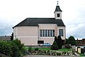
| Location | Hardegg, Hollabrunn District, Lower Austria, Austria | ||||
 | |||||
Subcategories
This category has the following 2 subcategories, out of 2 total.
Media in category "Saints Peter and Paul Church (Felling)"
The following 5 files are in this category, out of 5 total.
-
 GuentherZ 2010-04-03 0090 Felling Kirche.jpg 1,800 × 1,611; 504 KB
-
 GuentherZ 2010-04-03 0094 Felling Kirche Tafel Denkmalgeschuetzt.jpg 1,535 × 1,800; 456 KB
-
 GuentherZ 2010-04-03 0096 Felling Kirche Tafel.jpg 1,517 × 1,800; 385 KB
-
 GuentherZ 2010-08-28 0032 Felling Kirche.jpg 1,800 × 1,202; 842 KB
-
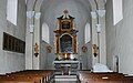 GuentherZ 2012-06-02 0043 Felling Kirche Altar alt.jpg 1,800 × 1,123; 1.02 MB


