Category:Saint Rupert Church (Trofaiach)
Jump to navigation
Jump to search
| Object location | | View all coordinates using: OpenStreetMap |
|---|
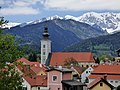
parish church and cemetery in Trofaiach, Austria  | |||||
| Upload media | |||||
| Instance of | |||||
|---|---|---|---|---|---|
| Location | Trofaiach, Leoben District, Styria, Austria | ||||
| Street address |
| ||||
| Architectural style | |||||
| Heritage designation | |||||
 | |||||
Subcategories
This category has only the following subcategory.
Media in category "Saint Rupert Church (Trofaiach)"
The following 14 files are in this category, out of 14 total.
-
 Fresko Hl. Christophorus 1420.jpg 1,473 × 1,965; 2.22 MB
-
 P1100199 Kath. Pfarrkirche St. Rupert Trofaiach.jpg 1,536 × 2,048; 1.97 MB
-
 Pfarrkirche Fassadenrenovierung 2000.JPG 1,989 × 1,300; 2.83 MB
-
 Pfarrkirche mit Reiting.JPG 1,486 × 1,120; 985 KB
-
 Pfarrkirche Rupert Trofaiach.jpg 4,608 × 3,456; 2.86 MB
-
 Pfarrkirche von Möllterrasse.jpg 2,560 × 1,920; 4.03 MB
-
 Saint Rupert Church Trofaiach 01.jpg 4,000 × 6,000; 9.96 MB
-
 Saint Rupert Church Trofaiach 02.jpg 4,000 × 6,000; 11.74 MB
-
 Saint Rupert Church Trofaiach 03.jpg 3,582 × 5,373; 5.05 MB
-
 Saint Rupert Church Trofaiach 04.jpg 4,000 × 6,000; 11.37 MB
-
 Saint Rupert Church Trofaiach 05.jpg 3,584 × 5,375; 5.09 MB
-
 Saint Rupert Church Trofaiach 06.jpg 4,000 × 6,000; 11.3 MB
-
 Trofaiach Fresko Kreuzabnahme Kircheneingang.jpg 1,936 × 1,296; 2.52 MB
-
 Trofaiach Rupertikirche Aquarell.JPG 1,409 × 1,794; 1.55 MB


