Category:Saint Lawrence Church (Drösing)
Jump to navigation
Jump to search
| Object location | | View all coordinates using: OpenStreetMap |
|---|
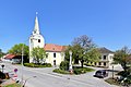
church building in Drösing, Lower Austria   | |||||
| Upload media | |||||
| Instance of | |||||
|---|---|---|---|---|---|
| Location | Drösing, Gänserndorf District, Lower Austria, Austria | ||||
| Street address |
| ||||
| Heritage designation | |||||
 | |||||
Media in category "Saint Lawrence Church (Drösing)"
The following 10 files are in this category, out of 10 total.
-
 Drosing Catholic Church Interior.JPG 1,600 × 1,200; 303 KB
-
 Drösing - Kirche.JPG 2,886 × 3,811; 8.06 MB
-
 Drösing 01.jpg 3,008 × 2,000; 1.29 MB
-
 Drösing 02.jpg 3,008 × 2,000; 586 KB
-
 Drösing.JPG 4,547 × 3,031; 12.11 MB
-
 Kirche 6517 Hauptaltar in A-2265 Drösing.jpg 3,888 × 5,633; 3.92 MB
-
 Kirche 6517 Kanzel in A-2265 Drösing.jpg 4,016 × 5,397; 2.44 MB
-
 Kirche 6517 linker Seitenaltar in A-2265 Drösing.jpg 4,016 × 5,354; 2.7 MB
-
 Kirche 6517 Orgelempore in A-2265 Drösing.jpg 6,016 × 4,016; 2.88 MB
-
 Kirche 6517 rechter Seitenaltar in A-2265 Drösing.jpg 3,807 × 5,495; 2.87 MB


