Category:Saint George cemetery chapel in Knorydy
Jump to navigation
Jump to search
| Object location | | View all coordinates using: OpenStreetMap |
|---|
Polski: Knorydy - prawosławna cerkiew cmentarna p.w. św. Jerzego Zwycięzcy
 | |||||
| Upload media | |||||
| Instance of | |||||
|---|---|---|---|---|---|
| Named after | |||||
| Made from material | |||||
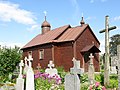
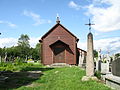
| Location | Knorydy, Gmina Bielsk Podlaski, Bielsk County, Podlaskie Voivodeship, Poland | ||||
| Diocese | |||||
 | |||||
Media in category "Saint George cemetery chapel in Knorydy"
The following 6 files are in this category, out of 6 total.
-
 Kaplica św Jerzego w Knorydach 1.JPG 2,592 × 1,944; 2.85 MB
-
 Kaplica św Jerzego w Knorydach 2.JPG 2,592 × 1,944; 2.43 MB
-
 Kaplica św Jerzego w Knorydach 3.JPG 2,592 × 1,944; 2.5 MB
-
 Kaplica św Jerzego w Knorydach 4.JPG 2,592 × 1,944; 1.55 MB
-
 Kaplica św Jerzego w Knorydach 5.JPG 2,592 × 1,944; 2.74 MB
-
 Kaplica św Jerzego w Knorydach 6.JPG 2,256 × 1,692; 1.77 MB


