Category:Saint Florian Church (Unterrohr)
Jump to navigation
Jump to search
| Object location | | View all coordinates using: OpenStreetMap |
|---|
| This category shows the protected monument with the number 57759 in Austria. (Commons, de, Wikidata) |
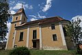
church building in Rohr bei Hartberg, Austria  | |||||
| Upload media | |||||
| Instance of | |||||
|---|---|---|---|---|---|
| Named after | |||||
| Location | Rohr bei Hartberg, Hartberg-Fürstenfeld District, Styria, Austria | ||||
| Street address |
| ||||
| Heritage designation | |||||
 | |||||
Subcategories
This category has only the following subcategory.
Media in category "Saint Florian Church (Unterrohr)"
The following 4 files are in this category, out of 4 total.
-
 Pfarrkirche Unterrohr HF.JPG 3,648 × 5,472; 6.99 MB
-
 Saint Florian Church Unterrohr 01.jpg 4,000 × 6,000; 12.41 MB
-
 Unterrohr Kirche.JPG 5,472 × 3,648; 7.98 MB
-
 Unterrohr-Kirche 3088.jpg 3,906 × 2,602; 1.61 MB


