Category:Saint Florian Church (Rudersdorf)
Jump to navigation
Jump to search
| Object location | | View all coordinates using: OpenStreetMap |
|---|
church building in Burgenland, Austria  | |||||
| Upload media | |||||
| Instance of | |||||
|---|---|---|---|---|---|
| Named after | |||||
| Location | Rudersdorf, Jennersdorf District, Burgenland, Austria | ||||
| Street address |
| ||||
| Heritage designation | |||||
 | |||||
Subcategories
This category has only the following subcategory.
Media in category "Saint Florian Church (Rudersdorf)"
The following 4 files are in this category, out of 4 total.
-
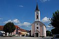 Pfarrkirche Rudersdorf im Burgenland.jpg 3,725 × 2,493; 3.86 MB
-
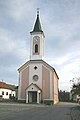 Rudersdorf römisch-katholische Pfarrkirche.jpg 2,048 × 3,072; 2.52 MB
-
 Saint Florian Church Rudersdorf 01.jpg 3,679 × 5,518; 4.46 MB
-
 Saint Florian Church Rudersdorf 02.jpg 5,231 × 3,488; 5.2 MB


