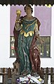
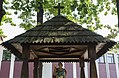
Category:Saint Barbara chapel in Tarnobrzeg
Jump to navigation
Jump to search
| Object location | | View all coordinates using: OpenStreetMap |
|---|
 | |||||
| Upload media | |||||
| Instance of | |||||
|---|---|---|---|---|---|
| Location | Tarnobrzeg, Subcarpathian Voivodeship, Poland | ||||
| Street address |
| ||||
| Heritage designation |
| ||||
 | |||||
Media in category "Saint Barbara chapel in Tarnobrzeg"
The following 12 files are in this category, out of 12 total.
-
 2014 Tarnobrzeg, kapliczka św. Barbary 01.JPG 3,309 × 2,504; 5.5 MB
-
 2014 Tarnobrzeg, kapliczka św. Barbary 02.JPG 2,993 × 4,304; 7.75 MB
-
 2014 Tarnobrzeg, kapliczka św. Barbary 03.JPG 3,146 × 4,536; 7.91 MB
-
 2014 Tarnobrzeg, kapliczka św. Barbary 04.JPG 3,110 × 4,216; 8.53 MB
-
 2014 Tarnobrzeg, kapliczka św. Barbary 05.JPG 3,264 × 2,340; 6.3 MB
-
 2014 Tarnobrzeg, kapliczka św. Barbary 06.JPG 2,869 × 3,033; 6.68 MB
-
 2014 Tarnobrzeg, kapliczka św. Barbary 07.JPG 4,754 × 3,136; 9.86 MB
-
 2014 Tarnobrzeg, kapliczka św. Barbary 08.JPG 2,784 × 4,314; 6.01 MB
-
 2014 Tarnobrzeg, kapliczka św. Barbary 09.JPG 2,447 × 4,045; 5.08 MB
-
 2014 Tarnobrzeg, kapliczka św. Barbary 10.JPG 2,230 × 3,172; 4.27 MB
-
 2014 Tarnobrzeg, kapliczka św. Barbary 11.JPG 4,127 × 2,696; 7.56 MB
-
 Kapliczka p.w. św. Barbary.JPG 3,264 × 4,928; 8.27 MB


