Category:Saint Afra Church (Eggendorf im Thale)
Jump to navigation
Jump to search
| Object location | | View all coordinates using: OpenStreetMap |
|---|
| This category shows the protected monument with the number 21430 in Austria. (Commons, de, Wikidata) |
church building in Hollabrunn, Austria   | |||||
| Upload media | |||||
| Instance of | |||||
|---|---|---|---|---|---|
| Named after | |||||
| Location | Hollabrunn, Hollabrunn District, Lower Austria, Austria | ||||
| Architectural style | |||||
| Heritage designation | |||||
 | |||||
Media in category "Saint Afra Church (Eggendorf im Thale)"
The following 11 files are in this category, out of 11 total.
-
 Eggendorf Thale Orgel.jpg 2,048 × 1,365; 774 KB
-
 GuentherZ 2012-03-10 0698 Eggendorf im Thale Kirche Altar.jpg 1,800 × 1,205; 1.09 MB
-
 GuentherZ 2012-03-10 0699 Eggendorf im Thale Kirche.jpg 1,800 × 1,551; 1.39 MB
-
 Kirche 21430 Altar Seitenkapelle in A-2031 Eggendorf im Thale.jpg 4,907 × 3,517; 3.75 MB
-
 Kirche 21430 Hauptaltar in A-2031 Eggendorf im Thale.jpg 4,016 × 6,016; 5.77 MB
-
 Kirche 21430 in A-2031 Eggendorf im Thale (b).jpg 5,447 × 3,543; 3.44 MB
-
 Kirche 21430 in A-2031 Eggendorf im Thale.jpg 6,016 × 3,838; 3.21 MB
-
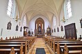 Kirche 21430 Innen in A-2031 Eggendorf im Thale.jpg 6,016 × 4,016; 3.38 MB
-
 Kirche 21430 Kanzel in A-2031 Eggendorf im Thale.jpg 6,016 × 3,802; 3.22 MB
-
 Kirche 21430 Orgelempore in A-2031 Eggendorf im Thale.jpg 6,016 × 4,016; 2.76 MB
-
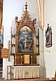 Kirche 21430 rechter Seitenaltar in A-2031 Eggendorf im Thale.jpg 4,016 × 5,833; 3.29 MB


.jpg)


