Category:SVG meteorology
Jump to navigation
Jump to search
Media in category "SVG meteorology"
The following 40 files are in this category, out of 40 total.
-
 Air masses.svg 883 × 405; 692 KB
-
 Altostratus Symbol.svg 250 × 150; 642 bytes
-
 Axes tephigramme.svg 700 × 820; 39 KB
-
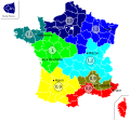 BBC 2005 rigueur climatique-2.svg 588 × 550; 197 KB
-
 BBC 2005 rigueur climatique.svg 588 × 550; 182 KB
-
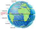 Earth Global Circulation - de.svg 944 × 763; 144 KB
-
 Earth Global Circulation - en.svg 950 × 770; 154 KB
-
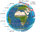 Earth Global Circulation - fa.svg 910 × 801; 892 KB
-
 Earth Global Circulation - ru.svg 1,050 × 800; 146 KB
-
 Emagramme adiabatiques humides.svg 800 × 600; 46 KB
-
 Emagramme adiabatiques seches.svg 800 × 600; 47 KB
-
 Emagramme altitude cumulus.svg 800 × 600; 128 KB
-
 Emagramme.svg 800 × 600; 91 KB
-
 Fujita scale technical-es.svg 428 × 560; 283 KB
-
 Fujita scale technical-fr.svg 428 × 560; 283 KB
-
 Fujita scale technical.svg 428 × 560; 376 KB
-
 Geostrophy.svg 1,117 × 619; 15 KB
-
 LCL-NCA.svg 276 × 264; 11 KB
-
 Miejska wyspa ciepła 2-ru.svg 680 × 565; 13 KB
-
 Miejska wyspa ciepła 2.svg 680 × 565; 12 KB
-
 Miejska wyspa ciepła-ru.svg 623 × 299; 7 KB
-
 Miejska wyspa ciepła.svg 623 × 299; 7 KB
-
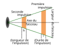
 Radar-beam.svg 400 × 300; 12 KB
-
 Radar-faisceau es.svg 400 × 300; 12 KB
-
 Radar-faisceau zh.svg 400 × 300; 11 KB
-
 Radar-faisceau.svg 400 × 300; 13 KB
-
 Radar-hauteur-en.svg 563 × 313; 42 KB
-
 Radar-hauteur-es.svg 563 × 313; 41 KB
-
 Radar-hauteur-fr.svg 563 × 313; 41 KB
-
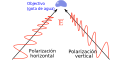
 Radar-polarisation en.svg 713 × 383; 14 KB
-
 Radar-polarisation es.svg 713 × 383; 14 KB
-
 Radar-polarisation zh.svg 713 × 383; 13 KB
-
 Radar-polarisation.svg 713 × 383; 31 KB
-
 RT 2005 zone climatique-2.svg 588 × 550; 193 KB
-
 RT 2005 zone climatique.svg 588 × 550; 183 KB
-
 Salt lake city.svg 1,063 × 1,063; 148 KB
-
 Temperatuur-hoogte-diagram.svg 670 × 580; 24 KB
-
 Type de precipitation dans un blocage air froid.svg 602 × 500; 76 KB
-
 Téphigramme vierge.svg 597 × 855; 41 KB
-
 Téphigramme voile cirrus.svg 607 × 810; 40 KB


