Category:SVG locator maps of governorates in Palestine (location map scheme)
Jump to navigation
Jump to search

|
SVG maps in this category are part of a locator map series applying the (de) widespread location map scheme. Please see root category to browse for more. |
.svg)
.svg)
.svg)
.svg)
.svg)
.svg)
.svg)
Locator maps design recommendations ▼ | |
|---|---|
Principles
Design Guidelines are based on ▸location map design of the German map shop (in German). It's preferable to derive new locator maps from existing location maps. Please keep both size and ratio in this case. Thus the new locator maps may still be applied as location map (▸Guide). Marker color is supposed to be darkred. Waterbodies may be transparent, to show other objects better. Please be aware that this guide is only a recommendation. It’s not an inevitable law!
Highlight small areas
“Remote” areas and mini maps
Mini maps show where the depicted area actually is situated. Check out ▸Vorlage:Positionskarte+ (in German) and ▸Modèle:Carte en coin (in French) of how to insert a mini map in virtually every map.
Disputed areas
Greyed special objects
Backgrounds
|

-en.svg)

.svg)
.svg)
.svg)

_(US48).svg)
_(small_islands_magnified)_(-mini_map_-rivers).svg)
.svg)
_(extra_close)_(US48).svg)
.svg)
_(zoom).svg)

.svg)


_(UNMIK).svg)
.svg)
_(disputed_hatched).svg)
_(claimed_and_disputed_hatched).svg)
.svg)
.svg)
_(%2Ball_claims_hatched).svg)

.svg)
_(shade).svg)
_(shade)_(special_marker).svg)
_(-mini_map).svg)
_(-mini_map).svg)
_(-mini_map).svg)


.svg)

.svg)
Media in category "SVG locator maps of governorates in Palestine (location map scheme)"
The following 31 files are in this category, out of 31 total.
-
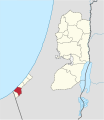
 Bethlehem in Palestine.svg 639 × 736; 213 KB
-
 Deir al-Balah in Palestine.svg 639 × 736; 199 KB
-
 Gaza in Palestine.svg 639 × 736; 199 KB
-
 Gaza Strip in Palestine.svg 639 × 736; 199 KB
-
 Hebron in Palestine.svg 639 × 736; 200 KB
-
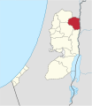
 Jenin in Palestine.svg 639 × 736; 200 KB
-
 Jericho in Palestine.svg 639 × 736; 213 KB
-
 Jerusalem in Palestine (+claimed hatched).svg 639 × 736; 216 KB
-
 Jerusalem in Palestine (+claimed).svg 639 × 736; 213 KB
-
 Jerusalem in Palestine.svg 639 × 736; 213 KB
-
 Khan Yunis in Palestine.svg 639 × 736; 199 KB
-
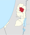 Nablus in Palestine.svg 639 × 736; 200 KB
-
 North Gaza in Palestine.svg 639 × 736; 199 KB
-
 Qalqilya in Palestine.svg 639 × 736; 207 KB
-
 Rafah in Palestine.svg 639 × 736; 199 KB
-
 Ramallah and Al-Bireh in Palestine (+claimed hatched).svg 639 × 736; 204 KB
-
 Ramallah and Al-Bireh in Palestine (+claimed).svg 639 × 736; 200 KB
-
 Ramallah and Al-Bireh in Palestine.svg 639 × 736; 200 KB
-
 Salfit in Palestine.svg 639 × 736; 200 KB
-
 Tubas in Palestine.svg 639 × 736; 200 KB
-
 Tulkarm in Palestine.svg 639 × 736; 200 KB
-
 West Bank in Palestine (+claimed hatched).svg 639 × 736; 204 KB
-
 West Bank in Palestine (+claimed).svg 639 × 736; 199 KB
-
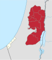
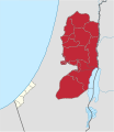
 West Bank in Palestine.svg 639 × 736; 199 KB
-
 Zone C in Israel.svg 270 × 530; 946 KB
-
 Zones A and B in Israel (Zone C hatched).svg 639 × 736; 958 KB
-
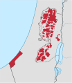
 Zones A and B in Israel.svg 639 × 736; 955 KB
-

-
-

-
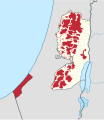 Zones A and B in the occupied palestinian territories.svg 639 × 736; 903 KB


.svg)
.svg)


.svg)
.svg)


.svg)
.svg)


.svg)

_(Zone_C_hatched).svg)
.svg)
.svg)
