Category:SVG locator maps of districts of the Bahamas (location map scheme)
Jump to navigation
Jump to search

|
SVG maps in this category are part of a locator map series applying the (de) widespread location map scheme. Please see root category to browse for more. |
.svg)
.svg)
.svg)
.svg)
.svg)
.svg)
.svg)
Locator maps design recommendations ▼ | |
|---|---|
Principles
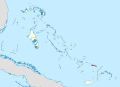
Design Guidelines are based on ▸location map design of the German map shop (in German). It's preferable to derive new locator maps from existing location maps. Please keep both size and ratio in this case. Thus the new locator maps may still be applied as location map (▸Guide). Marker color is supposed to be darkred. Waterbodies may be transparent, to show other objects better. Please be aware that this guide is only a recommendation. It’s not an inevitable law!
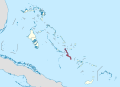
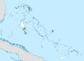
Highlight small areas
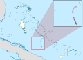
“Remote” areas and mini maps
Mini maps show where the depicted area actually is situated. Check out ▸Vorlage:Positionskarte+ (in German) and ▸Modèle:Carte en coin (in French) of how to insert a mini map in virtually every map.
Disputed areas
Greyed special objects
Backgrounds
|

-en.svg)

.svg)
.svg)
.svg)

_(US48).svg)
_(small_islands_magnified)_(-mini_map_-rivers).svg)
.svg)
_(extra_close)_(US48).svg)
.svg)
_(zoom).svg)

.svg)


_(UNMIK).svg)
.svg)
_(disputed_hatched).svg)
_(claimed_and_disputed_hatched).svg)
.svg)
.svg)
_(%2Ball_claims_hatched).svg)

.svg)
_(shade).svg)
_(shade)_(special_marker).svg)
_(-mini_map).svg)
_(-mini_map).svg)
_(-mini_map).svg)


.svg)

.svg)
Media in category "SVG locator maps of districts of the Bahamas (location map scheme)"
The following 90 files are in this category, out of 90 total.
-
 Acklins in Bahamas (+glow).svg 1,559 × 1,124; 706 KB
-
 Acklins in Bahamas (zoom).svg 1,559 × 1,124; 606 KB
-
 Acklins in Bahamas.svg 1,559 × 1,124; 699 KB
-
 Berry Islands in Bahamas (+glow).svg 1,559 × 1,124; 703 KB
-
 Berry Islands in Bahamas (zoom +glow).svg 1,559 × 1,124; 752 KB
-
 Berry Islands in Bahamas (zoom).svg 1,559 × 1,124; 744 KB
-
 Berry Islands in Bahamas.svg 1,559 × 1,124; 699 KB
-
 Bimini in Bahamas (+glow).svg 1,559 × 1,124; 707 KB
-
 Black Point in Bahamas (+glow).svg 1,559 × 1,124; 700 KB
-
 Black Point in Bahamas (+special marker).svg 1,559 × 1,124; 699 KB
-
 Black Point in Bahamas (zoom +special marker).svg 1,559 × 1,124; 751 KB
-
 Black Point in Bahamas (zoom).svg 1,559 × 1,124; 751 KB
-
 Black Point in Bahamas.svg 1,559 × 1,124; 699 KB
-
 Cat Island in Bahamas (zoom).svg 1,559 × 1,124; 743 KB
-
 Cat Island in Bahamas.svg 1,559 × 1,124; 699 KB
-
 Central Abaco in Bahamas (zoom).svg 1,559 × 1,124; 804 KB
-
 Central Abaco in Bahamas.svg 1,559 × 1,124; 696 KB
-
 Central Andros in Bahamas (zoom).svg 1,559 × 1,124; 813 KB
-
 Central Andros in Bahamas.svg 1,559 × 1,124; 699 KB
-
 Central Eleuthera in Bahamas (+glow).svg 1,559 × 1,124; 701 KB
-
 Central Eleuthera in Bahamas (zoom).svg 1,559 × 1,124; 737 KB
-
 Central Eleuthera in Bahamas.svg 1,559 × 1,124; 699 KB
-
 Crooked Island in Bahamas (+glow).svg 1,559 × 1,124; 705 KB
-
 Crooked Island in Bahamas (zoom).svg 1,559 × 1,124; 734 KB
-
 Crooked Island in Bahamas.svg 1,559 × 1,124; 700 KB
-
 East Grand Bahama in Bahamas (zoom).svg 1,559 × 1,124; 760 KB
-
 East Grand Bahama in Bahamas.svg 1,559 × 1,124; 699 KB
-
 Exuma and Cays in Bahamas (+glow).svg 1,559 × 1,124; 715 KB
-
 Exuma and Cays in Bahamas (zoom +glow).svg 1,559 × 1,124; 805 KB
-
 Exuma and Cays in Bahamas (zoom).svg 1,559 × 1,124; 777 KB
-
 Exuma and Cays in Bahamas.svg 1,559 × 1,124; 699 KB
-
 Freeport in Bahamas (+special marker).svg 1,559 × 1,124; 699 KB
-
 Freeport in Bahamas (zoom).svg 1,559 × 1,124; 760 KB
-
 Freeport in Bahamas.svg 1,559 × 1,124; 699 KB
-
 Grand Cay in Bahamas (+glow).svg 1,559 × 1,124; 701 KB
-
 Grand Cay in Bahamas (zoom +glow).svg 1,559 × 1,124; 763 KB
-
 Grand Cay in Bahamas (zoom).svg 1,559 × 1,124; 760 KB
-
 Green Turtle Cay in Bahamas (+glow).svg 1,559 × 1,124; 700 KB
-
 Green Turtle Cay in Bahamas (+special marker).svg 1,559 × 1,124; 699 KB
-
 Green Turtle Cay in Bahamas (zoom +glow).svg 1,559 × 1,124; 805 KB
-
 Green Turtle Cay in Bahamas (zoom).svg 1,559 × 1,124; 804 KB
-
 Harbour Island in Bahamas (+special marker).svg 1,559 × 1,124; 699 KB
-
 Harbour Island in Bahamas (zoom).svg 1,559 × 1,124; 737 KB
-
 Hope Town in Bahamas (+glow).svg 1,559 × 1,124; 697 KB
-
 Hope Town in Bahamas (zoom +glow).svg 1,559 × 1,124; 807 KB
-
 Hope Town in Bahamas (zoom).svg 1,559 × 1,124; 804 KB
-
 Hope Town in Bahamas.svg 1,559 × 1,124; 696 KB
-
 Inagua in Bahamas (zoom).svg 1,559 × 1,124; 735 KB
-
 Inagua in Bahamas.svg 1,559 × 1,124; 699 KB
-
 Long Island in Bahamas (+glow).svg 1,559 × 1,124; 704 KB
-
 Long Island in Bahamas (zoom).svg 1,559 × 1,124; 743 KB
-
 Long Island in Bahamas.svg 1,559 × 1,124; 699 KB
-
 Mangrove Cay in Bahamas (zoom).svg 1,559 × 1,124; 813 KB
-
 Mangrove Cay in Bahamas.svg 1,559 × 1,124; 699 KB
-
 Mayaguana in Bahamas (+glow).svg 1,559 × 1,124; 701 KB
-
 Mayaguana in Bahamas (zoom).svg 1,559 × 1,124; 735 KB
-
 Mayaguana in Bahamas.svg 1,559 × 1,124; 699 KB
-
 Moores Island in Bahamas (+special marker).svg 1,559 × 1,124; 699 KB
-
 Moores Island in Bahamas (zoom +glow).svg 1,559 × 1,124; 806 KB
-
 Moores Island in Bahamas (zoom).svg 1,559 × 1,124; 804 KB
-
 Moores Island in Bahamas.svg 1,559 × 1,124; 696 KB
-
 New Providence in Bahamas (+special marker).svg 1,559 × 1,124; 700 KB
-
 New Providence in Bahamas (zoom).svg 1,559 × 1,124; 744 KB
-
 New Providence in Bahamas.svg 1,559 × 1,124; 701 KB
-
 North Abaco in Bahamas (+glow).svg 1,559 × 1,124; 707 KB
-
 North Abaco in Bahamas (zoom).svg 1,559 × 1,124; 804 KB
-
 North Abaco in Bahamas.svg 1,559 × 1,124; 696 KB
-
 North Andros in Bahamas (zoom).svg 1,559 × 1,124; 813 KB
-
 North Andros in Bahamas.svg 1,559 × 1,124; 699 KB
-
 North Eleuthera in Bahamas (+glow).svg 1,559 × 1,124; 703 KB
-
 North Eleuthera in Bahamas (zoom).svg 1,559 × 1,124; 737 KB
-
 North Eleuthera in Bahamas.svg 1,559 × 1,124; 699 KB
-
 Ragged Island in Bahamas (+glow).svg 1,559 × 1,124; 704 KB
-
 Ragged Island in Bahamas (zoom).svg 1,559 × 1,124; 724 KB
-
 Rum Cay in Bahamas (+glow).svg 1,559 × 1,124; 701 KB
-
 Rum Cay in Bahamas (zoom).svg 1,559 × 1,124; 743 KB
-
 Rum Cay in Bahamas.svg 1,559 × 1,124; 699 KB
-
 San Salvador in Bahamas (+glow).svg 1,559 × 1,124; 701 KB
-
 San Salvador in Bahamas (zoom).svg 1,559 × 1,124; 743 KB
-
 San Salvador in Bahamas.svg 1,559 × 1,124; 699 KB
-
 South Abaco in Bahamas.svg 1,559 × 1,124; 696 KB
-
 South Andros in Bahamas (zoom).svg 1,559 × 1,124; 813 KB
-
 South Andros in Bahamas.svg 1,559 × 1,124; 699 KB
-
 South Eleuthera in Bahamas (+glow).svg 1,559 × 1,124; 702 KB
-
 South Eleuthera in Bahamas (zoom).svg 1,559 × 1,124; 737 KB
-
 South Eleuthera in Bahamas.svg 1,559 × 1,124; 699 KB
-
 Spanish Wells in Bahamas (+special marker).svg 1,559 × 1,124; 699 KB
-
 Spanish Wells in Bahamas (zoom).svg 1,559 × 1,124; 737 KB
-
 West Grand Bahama in Bahamas (zoom).svg 1,559 × 1,124; 760 KB
-
 West Grand Bahama in Bahamas.svg 1,559 × 1,124; 699 KB
.svg)

.svg)
.svg)
.svg)

.svg)
.svg)
.svg)
.svg)
.svg)

.svg)

.svg)

.svg)

.svg)
.svg)

.svg)
.svg)

.svg)

.svg)
.svg)
.svg)

.svg)
.svg)

.svg)
.svg)
.svg)
.svg)
.svg)
.svg)
.svg)
.svg)
.svg)
.svg)
.svg)
.svg)

.svg)

.svg)
.svg)

.svg)

.svg)
.svg)

.svg)
.svg)
.svg)

.svg)
.svg)

.svg)
.svg)

.svg)

.svg)
.svg)

.svg)
.svg)
.svg)
.svg)

.svg)
.svg)


.svg)

.svg)
.svg)

.svg)
.svg)
.svg)
