Category:SVG locator maps of counties in Hungary (location map scheme)
Jump to navigation
Jump to search

|
SVG maps in this category are part of a locator map series applying the (de) widespread location map scheme. Please see root category to browse for more. |
.svg)
.svg)
.svg)
.svg)
.svg)
.svg)
.svg)
Locator maps design recommendations ▼ | |
|---|---|
Principles
Design Guidelines are based on ▸location map design of the German map shop (in German). It's preferable to derive new locator maps from existing location maps. Please keep both size and ratio in this case. Thus the new locator maps may still be applied as location map (▸Guide). Marker color is supposed to be darkred. Waterbodies may be transparent, to show other objects better. Please be aware that this guide is only a recommendation. It’s not an inevitable law!
Highlight small areas
“Remote” areas and mini maps
Mini maps show where the depicted area actually is situated. Check out ▸Vorlage:Positionskarte+ (in German) and ▸Modèle:Carte en coin (in French) of how to insert a mini map in virtually every map.
Disputed areas
Greyed special objects
Backgrounds
|

-en.svg)

.svg)
.svg)
.svg)

_(US48).svg)
_(small_islands_magnified)_(-mini_map_-rivers).svg)
.svg)
_(extra_close)_(US48).svg)
.svg)
_(zoom).svg)

.svg)


_(UNMIK).svg)
.svg)
_(disputed_hatched).svg)
_(claimed_and_disputed_hatched).svg)
.svg)
.svg)
_(%2Ball_claims_hatched).svg)

.svg)
_(shade).svg)
_(shade)_(special_marker).svg)
_(-mini_map).svg)
_(-mini_map).svg)
_(-mini_map).svg)


.svg)

.svg)
Media in category "SVG locator maps of counties in Hungary (location map scheme)"
The following 21 files are in this category, out of 21 total.
-
 Bacs-Kiskun in Hungary.svg 1,210 × 746; 302 KB
-
 Baranya in Hungary.svg 1,210 × 746; 302 KB
-
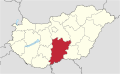
 Bekes in Hungary.svg 1,210 × 746; 302 KB
-
 Borsod-Abauj-Zemplen in Hungary.svg 1,210 × 746; 301 KB
-
 Budapest in Hungary.svg 1,210 × 746; 302 KB
-
 Csongrad in Hungary.svg 1,210 × 746; 302 KB
-
 Fejer in Hungary.svg 1,210 × 746; 302 KB
-
 Gyor-Moson-Sopron in Hungary.svg 1,210 × 746; 302 KB
-
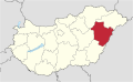 Hajdu-Bihar in Hungary.svg 1,210 × 746; 302 KB
-
 Heves in Hungary.svg 1,210 × 746; 302 KB
-
 Hongrie localisation Pest.svg 1,052 × 744; 2.61 MB
-
 Jasz-Nagykun-Szolnok in Hungary.svg 1,210 × 746; 302 KB
-
 Komarom-Esztergom in Hungary.svg 1,210 × 746; 302 KB
-
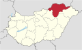
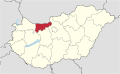
 Nograd in Hungary.svg 1,210 × 746; 302 KB
-
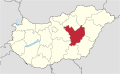
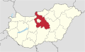 Pest in Hungary.svg 1,210 × 746; 302 KB
-
 Somogy in Hungary.svg 1,210 × 746; 302 KB
-
 Szabolcs-Szatmar-Bereg in Hungary.svg 1,210 × 746; 301 KB
-
 Tolna in Hungary.svg 1,210 × 746; 302 KB
-
 Vas in Hungary.svg 1,210 × 746; 301 KB
-
 Veszprem in Hungary.svg 1,210 × 746; 302 KB
-
 Zala in Hungary.svg 1,210 × 746; 302 KB


