Category:SVG labeled maps of administrative divisions of countries of North America (location map scheme) (english)
Jump to navigation
Jump to search


.svg)


_(Paris_zoom).svg)
.svg)
,_administrative_divisions_-_de_-_colored_(multizoom).svg)
_-_colored.svg)
.svg)
,_administrative_divisions_-_Nmbrs_(multizoom).svg)
,_administrative_divisions_-_de_-_colored.svg)
_-_de_-_colored.svg)

.svg)

.svg)
Media in category "SVG labeled maps of administrative divisions of countries of North America (location map scheme) (english)"
The following 7 files are in this category, out of 7 total.
-
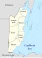 Belize, administrative divisions - en - monochrome.svg 788 × 1,092; 177 KB
-
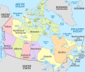 Canada, administrative divisions - en - colored.svg 1,084 × 920; 859 KB
-
 Dominica, administrative divisions - en - monochrome.svg 2,500 × 3,700; 119 KB
-
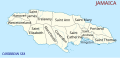 Jamaica, administrative divisions (parishes) - en - monochrome.svg 1,134 × 546; 141 KB
-
 Saint Kitts and Nevis, administrative divisions - en - monochrome.svg 1,264 × 1,170; 169 KB
-
 United States (+overseas), administrative divisions - en - colored (zoom).svg 1,339 × 864; 5.4 MB
-
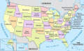 United States, administrative divisions - en - colored.svg 1,181 × 731; 3.2 MB


_-_en_-_monochrome.svg)

,_administrative_divisions_-_en_-_colored_(zoom).svg)
