Category:Rupert Covered Bridge
Jump to navigation
Jump to search
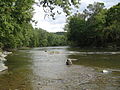
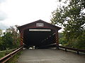
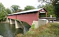
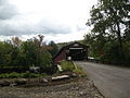
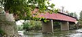
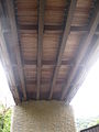
English: Rupert Covered Bridge No. 56 originally built in 1847 over Fishing Creek between the town of Bloomsburg and Montour Township in Columbia County, Pennsylvania, in the United States.
|
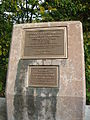
This is a category about a place or building that is listed on the National Register of Historic Places in the United States of America. Its reference number is 79003186. |
| Object location | | View all coordinates using: OpenStreetMap |
|---|
covered bridge in Columbia County, Pennsylvania  | |||||
| Upload media | |||||
| Instance of | |||||
|---|---|---|---|---|---|
| Location | Columbia County, Pennsylvania | ||||
| Crosses | |||||
| Heritage designation |
| ||||
 | |||||
Media in category "Rupert Covered Bridge"
The following 17 files are in this category, out of 17 total.
-
 Fishing Creek near Rupert Covered Bridge.JPG 3,648 × 2,736; 3.57 MB
-
 Rupert Covered Bridge 1.JPG 3,648 × 2,736; 2.29 MB
-
 Rupert Covered Bridge 10.JPG 3,648 × 2,736; 2.53 MB
-
 Rupert Covered Bridge 11.JPG 2,736 × 3,648; 3.51 MB
-
 Rupert Covered Bridge 12.JPG 3,648 × 2,736; 3.99 MB
-
 Rupert Covered Bridge 13.jpg 5,612 × 3,535; 3.62 MB
-
 Rupert Covered Bridge 14.JPG 3,648 × 2,736; 2.77 MB
-
 Rupert Covered Bridge 15.JPG 3,648 × 2,736; 2.04 MB
-
 Rupert Covered Bridge 16.JPG 3,648 × 2,736; 2.81 MB
-
 Rupert Covered Bridge 2.JPG 3,648 × 2,736; 3.52 MB
-
 Rupert Covered Bridge 3.jpg 5,646 × 2,557; 2.91 MB
-
 Rupert Covered Bridge 4.JPG 2,736 × 3,648; 2.27 MB
-
 Rupert Covered Bridge 5.jpg 6,871 × 2,643; 2.79 MB
-
 Rupert Covered Bridge 6.JPG 2,736 × 3,648; 3.62 MB
-
 Rupert Covered Bridge 7.JPG 3,648 × 2,736; 2.24 MB
-
 Rupert Covered Bridge 8.jpg 8,076 × 3,600; 3.09 MB
-
 Rupert Covered Bridge 9.JPG 2,736 × 3,648; 1.82 MB


Categories:
- National Register of Historic Places in Columbia County, Pennsylvania
- Covered bridges in Pennsylvania
- Bridges in Columbia County, Pennsylvania
- Bridges on the National Register of Historic Places in Pennsylvania
- 1840s bridges in Pennsylvania
- Bridges in the United States completed in 1847
- Built in Pennsylvania in 1847
- Fishing Creek (North Branch Susquehanna River)
- Covered bridges on the National Register of Historic Places in Pennsylvania