Category:Ruhland 700 Jahre
Jump to navigation
Jump to search
| Object location | | View all coordinates using: OpenStreetMap |
|---|
Deutsch: Diese Kategorie erfasst die Vorbereitung und Ereignisse zur 700-Jahr-Feier der Stadt Ruhland
Subcategories
This category has the following 6 subcategories, out of 6 total.
Media in category "Ruhland 700 Jahre"
The following 24 files are in this category, out of 24 total.
-
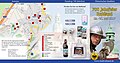
 Ruhland 700 Jahre, Flyer 1 außen.jpg 3,628 × 2,601; 4.22 MB
-
 Ruhland 700 Jahre, Flyer 1 innen.jpg 3,628 × 2,601; 5.32 MB
-
 Ruhland 700 Jahre, Flyer 2 außen.jpg 3,840 × 2,030; 1.16 MB
-
 Ruhland 700 Jahre, Flyer 2 innen.jpg 3,840 × 2,030; 1.34 MB
-
 Ruhland 700 Jahre, Strohfigur 01.jpg 3,240 × 2,160; 1.2 MB
-
 Ruhland 700 Jahre, Strohfigur 02.jpg 3,240 × 2,160; 1.36 MB
-
 Ruhland 700 Jahre, Veranstaltungsplan Kirche.jpg 1,704 × 2,272; 313 KB
-
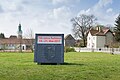
 Ruhland, 700 Jahre, Aufsteller am Stadteingang 01.jpg 2,272 × 1,704; 566 KB
-
 Ruhland, 700 Jahre, Aufsteller am Stadteingang 02.jpg 2,272 × 1,704; 592 KB
-
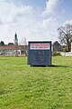
 Ruhland, 700 Jahre, Aufsteller am Stadteingang 03.jpg 2,272 × 1,224; 400 KB
-
 Ruhland, 700 Jahre, Aufsteller am Stadteingang 04.jpg 1,440 × 2,160; 825 KB
-
 Ruhland, 700 Jahre, Aufsteller am Stadteingang 05.jpg 1,440 × 2,160; 1.04 MB
-
 Ruhland, 700 Jahre, Aufsteller am Stadteingang 06.jpg 3,240 × 2,160; 1.92 MB
-
 Ruhland, 700 Jahre, Aufsteller am Stadteingang 07.jpg 1,440 × 2,160; 1,010 KB
-
 Ruhland, 700 Jahre, Aufsteller am Stadteingang 08.jpg 3,240 × 2,160; 1.88 MB
-
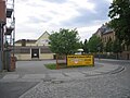
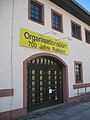 Ruhland, 700 Jahre, Organisationsbüro.jpg 1,704 × 2,272; 395 KB
-
 Ruhland, 700 Jahre, Plakat an der Elsterbrücke 01.jpg 868 × 861; 156 KB
-
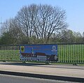
 Ruhland, 700 Jahre, Plakat an der Elsterbrücke 02.jpg 2,272 × 1,704; 584 KB
-
 Ruhland, 700 Jahre, Plakate an der Elsterbrücke 03.jpg 2,272 × 1,704; 526 KB
-
 Ruhland, 700 Jahre, Plakate an der Elsterbrücke 04.jpg 3,240 × 2,160; 2.09 MB
-
 Ruhland, 700 Jahre, Plakate an der Elsterbrücke 05.jpg 3,240 × 2,160; 2.51 MB
-
 Ruhland, Dresdener Str. 39 Ostansicht, Hoffest zur 700-Jahr-Feier 01.jpg 2,272 × 1,704; 480 KB
-
 Ruhland, Dresdener Str. 39 Ostansicht, Hoffest zur 700-Jahr-Feier 02.jpg 2,272 × 1,704; 538 KB
-
 Ruhland, Dresdener Str.., Hoffest Fleischerei Lehmann beim Stadtfest 700 Jahre.jpg 2,272 × 1,704; 576 KB


