Category:Rugeley
Jump to navigation
Jump to search
English: Rugeley is a historic market town in the county of Staffordshire, England. It lies on the northern edge of Cannock Chase, and is situated roughly midway between the towns of Stafford, Cannock, Lichfield, and Uttoxeter. The population as at the 2001 census was 22,724 (including the Brereton and Etchinghill wards).
Italiano: Rugeley è una cittadina di 22.724 abitanti, situata nella contea dello Staffordshire in Inghilterra.
Nederlands: Rugeley of Rudgeley is een dorp in het Engelse kiesdistrict Staffordshire. Het ligt tussen de steden Stafford, Cannock en Lichfield, en wordt doorkruist door de rivier de Trent en het Trent and Mersey Canal. Rugeley's zusterstad is Western Springs, in Illinois, de Verenigde Staten.
Română: Rugeley este un oraş în comitatul Staffordshire, regiunea West Midlands, Anglia. Oraşul se află în districtul Cannock Chase.
town in Staffordshire, England  | |||||
| Upload media | |||||
| Instance of | |||||
|---|---|---|---|---|---|
| Location | Cannock Chase, Staffordshire, West Midlands, England | ||||
| official website | |||||
 | |||||
Subcategories
This category has the following 20 subcategories, out of 20 total.
A
- Armitage Park (2 F)
B
- Brindley Bank Aqueduct (4 F)
C
- Colton Mill Bridge (5 F)
H
- Hagley Hall, Rugeley (1 F)
P
R
- Rugeley Power Station (51 F)
- Rugeley Town Hall (3 F)
- Rugeley War Memorial (1 F)
S
T
- Trent and Mersey Canal, Rugeley (58 F)
Media in category "Rugeley"
The following 200 files are in this category, out of 261 total.
(previous page) (next page)-
 32 and 34 Market Street, Rugeley.jpg 4,000 × 3,000; 3.26 MB
-
 A Grand Billiards Club - geograph.org.uk - 276689.jpg 640 × 429; 80 KB
-
 A mini roundabout on the Hednesford Road - geograph.org.uk - 3469397.jpg 1,142 × 857; 284 KB
-
 Albion Street, Rugeley - geograph.org.uk - 3791930.jpg 3,912 × 2,880; 2.76 MB
-
 Albion Street, Rugeley.jpg 4,608 × 3,456; 2.16 MB
-
 All weather sports pitch - geograph.org.uk - 3733576.jpg 1,600 × 1,199; 339 KB
-
 Anson Street - Rugeley - geograph.org.uk - 4030426.jpg 2,946 × 2,254; 2.71 MB
-
 Aqueduct north of Rugeley in Staffordshire - geograph.org.uk - 6164288.jpg 1,440 × 960; 1.36 MB
-
 Bedford Way, Rugeley - geograph.org.uk - 2430350.jpg 640 × 428; 103 KB
-
 Brereton sidings signal box - geograph.org.uk - 3177561.jpg 640 × 432; 107 KB
-
 Bridge over the canal at Rugeley, Staffordshire - geograph.org.uk - 6394222.jpg 1,280 × 1,280; 1.62 MB
-
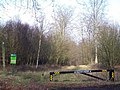 Bridleway in Brereton Hayes Wood - geograph.org.uk - 682618.jpg 640 × 480; 113 KB
-

-
 Brook - geograph.org.uk - 3836091.jpg 1,064 × 1,600; 599 KB
-
 Cambrian Lane, Rugeley. - geograph.org.uk - 2441816.jpg 640 × 428; 53 KB
-
 Canal and housing in Rugeley, Staffordshire - geograph.org.uk - 6393633.jpg 1,440 × 960; 1.28 MB
-
 Canal approaching Rugeley town centre, Staffordshire - geograph.org.uk - 6393202.jpg 1,440 × 960; 1.53 MB
-
 Canal approaching Rugeley town centre, Staffordshire - geograph.org.uk - 6393206.jpg 1,440 × 960; 1.39 MB
-
 Canal at Tan Yard Bridge in Rugeley, Staffordshire - geograph.org.uk - 6393653.jpg 1,440 × 960; 1.43 MB
-
 Canal bridge near Rugeley in Staffordshire - geograph.org.uk - 6394227.jpg 1,280 × 960; 1.23 MB
-
 Canal cruising near Rugeley in Staffordshire - geograph.org.uk - 6393199.jpg 1,440 × 960; 1.75 MB
-
 Canalside factory in Rugeley, Staffordshire - geograph.org.uk - 5358921.jpg 960 × 1,280; 1.13 MB
-
 Cannock Chase, Cannock, United Kingdom (Unsplash ALZ8ZYKwDv0).jpg 4,288 × 2,848; 4.21 MB
-
 Cannock Chase, Cannock, United Kingdom (Unsplash).jpg 5,760 × 3,840; 20.47 MB
-
 Cannock Chase, Slitting Mill - geograph.org.uk - 769820.jpg 640 × 480; 132 KB
-
 Cemetery in Rugeley, Staffordshire - geograph.org.uk - 6011994.jpg 1,400 × 900; 1.47 MB
-
 Chetwynd's Coppice, Near Rugeley - geograph.org.uk - 843421.jpg 640 × 480; 142 KB
-

-
 Church Bridge in Rugeley, Staffordshire - geograph.org.uk - 6011933.jpg 1,280 × 960; 1.48 MB
-
 Church of the Good Shepherd - geograph.org.uk - 3733595.jpg 1,600 × 1,064; 541 KB
-
 Church Street, Rugeley - geograph.org.uk - 1320149.jpg 640 × 480; 69 KB
-
 Church Street, Rugeley - geograph.org.uk - 3791934.jpg 4,000 × 3,000; 1.36 MB
-
 Colton Road, Rugeley (34403009291).jpg 4,608 × 3,456; 5.94 MB
-
 Competitors at the final control - geograph.org.uk - 5734408.jpg 640 × 480; 120 KB
-
 Coppice Lane - geograph.org.uk - 3469411.jpg 734 × 979; 453 KB
-
 Coppice Road, Rugeley - geograph.org.uk - 3420699.jpg 640 × 480; 60 KB
-
 Durham Drive, Rugeley - geograph.org.uk - 2426855.jpg 640 × 428; 86 KB
-
 Elmore Park - Rugeley (34409487542).jpg 4,608 × 3,456; 6.35 MB
-
 Elmore Park - Rugeley (34571298575).jpg 4,608 × 3,456; 6.2 MB
-
 Elmore Park - Rugeley - Hall Pool and bluebells (34441001031).jpg 4,608 × 3,456; 5.81 MB
-
 Elmore Park, Rugeley - geograph.org.uk - 3819662.jpg 4,000 × 3,000; 5.8 MB
-
 End of the Road. Rugeley - geograph.org.uk - 2493947.jpg 640 × 428; 106 KB
-
 Entering Rugeley - geograph.org.uk - 4030088.jpg 3,254 × 2,606; 3.54 MB
-
 Entering Rugeley on Penkridge Bank - geograph.org.uk - 3420652.jpg 640 × 480; 54 KB
-
 Farmland near Hagley Farm - geograph.org.uk - 3420659.jpg 640 × 480; 115 KB
-
 Fast food restaurant, Rugeley - geograph.org.uk - 3420740.jpg 640 × 496; 84 KB
-
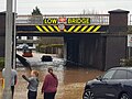 Flooding in Rugeley Staffs 2020.jpg 4,032 × 3,024; 611 KB
-
 Footbridge over Western Springs Road - geograph.org.uk - 4030408.jpg 2,909 × 2,509; 3.02 MB
-
 Footpath and farmland - geograph.org.uk - 3420750.jpg 640 × 480; 96 KB
-
 Footpath In Brereton Hayes Wood - geograph.org.uk - 681664.jpg 640 × 480; 131 KB
-
 Footpath Near The Slade - geograph.org.uk - 682636.jpg 640 × 480; 141 KB
-
 Forestry track to Lady Hill Coppice - geograph.org.uk - 3807113.jpg 1,200 × 1,600; 636 KB
-
 Forge Road in Rugeley - geograph.org.uk - 5053513.jpg 4,000 × 3,000; 3.75 MB
-
 Fortescue Lane, Rugeley - geograph.org.uk - 3791925.jpg 4,000 × 3,000; 1.04 MB
-
 Hagley News - geograph.org.uk - 3467454.jpg 1,142 × 857; 269 KB
-
 Hagley Road, Rugeley - geograph.org.uk - 2458517.jpg 640 × 428; 57 KB
-
 Hagley Road, Rugely - geograph.org.uk - 3420746.jpg 640 × 480; 43 KB
-

-
 Heron Street, Rugeley - geograph.org.uk - 3791922.jpg 4,000 × 3,000; 2.69 MB
-
 Hilsop Road, Rugeley - geograph.org.uk - 3420704.jpg 640 × 480; 68 KB
-
 Houses along the Trent ^ Mersey Canal - geograph.org.uk - 4555137.jpg 1,024 × 768; 275 KB
-
 Houses on Hagley Road, Rugely - geograph.org.uk - 3420744.jpg 640 × 480; 72 KB
-

-
 Jones Lane - geograph.org.uk - 3420663.jpg 640 × 480; 107 KB
-
 Keystone Lane, Rugeley - geograph.org.uk - 2192577.jpg 640 × 480; 89 KB
-
 Keystone Road, Rugeley - geograph.org.uk - 3751762.jpg 3,928 × 2,902; 3.91 MB
-
 Lady Hill Coppice - geograph.org.uk - 3806480.jpg 1,600 × 1,064; 375 KB
-
 Lake in the park, Rugeley - geograph.org.uk - 3420723.jpg 640 × 410; 70 KB
-
-

-

-
 Love Lane - geograph.org.uk - 3123139.jpg 640 × 480; 90 KB
-
 Lower Birches Way - geograph.org.uk - 2430339.jpg 640 × 428; 62 KB
-
 Lower Brook Street, Rugeley. - geograph.org.uk - 2438756.jpg 640 × 428; 82 KB
-
 Main road to Lichfield - geograph.org.uk - 1439829.jpg 640 × 426; 256 KB
-
 Market Street, Rugeley - geograph.org.uk - 3420717.jpg 640 × 480; 66 KB
-
 Market Street, Rugeley - geograph.org.uk - 843410.jpg 640 × 480; 61 KB
-
 Modern Housing Near the Power Station - geograph.org.uk - 498260.jpg 640 × 480; 71 KB
-
 Mooring near Rugeley in Staffordshire - geograph.org.uk - 6393061.jpg 1,440 × 960; 1.53 MB
-
 Mooring near Rugeley in Staffordshire - geograph.org.uk - 6393064.jpg 1,280 × 960; 1.38 MB
-
 New industrial estate, Lea Hall Road - geograph.org.uk - 551520.jpg 640 × 427; 82 KB
-
 New island on Rugeley Bypass - geograph.org.uk - 564149.jpg 640 × 480; 88 KB
-

-

-
 Pasture Near 'The Glen' - geograph.org.uk - 682632.jpg 640 × 480; 113 KB
-
 Penkridge Bank - geograph.org.uk - 3420662.jpg 640 × 480; 99 KB
-
 Penkridge Bank Road - geograph.org.uk - 3467437.jpg 914 × 685; 429 KB
-
 Penny Bank - geograph.org.uk - 3836038.jpg 1,600 × 1,200; 329 KB
-

-

-

-
 Pylons near Rugeley - geograph.org.uk - 2220269.jpg 640 × 430; 118 KB
-
 Rail Bridge over the River Trent, Rugeley (geograph 2493973).jpg 640 × 428; 108 KB
-

-
 Railway bridge - viaduct from Horse Fair, Rugeley - subway (33707315614).jpg 4,608 × 3,456; 5.96 MB
-

-
 Railway viaduct over the River Trent - geograph.org.uk - 1434906.jpg 640 × 480; 280 KB
-
 Recreation ground, Etchinghill - geograph.org.uk - 3420760.jpg 640 × 480; 54 KB
-
 Red post box, Colton Road, Rugeley (34421515171).jpg 3,456 × 4,608; 6.21 MB
-

-
 Rifle Range and Drill Hall - geograph.org.uk - 4490451.jpg 1,600 × 1,064; 319 KB
-

-
 River Trent east of Rugeley, from the train - geograph.org.uk - 3577184.jpg 1,600 × 865; 164 KB
-
 Road-rail vehicle at Rugeley - geograph.org.uk - 4199791.jpg 1,024 × 768; 126 KB
-
 Rugeley (33948432481).jpg 3,000 × 4,000; 2.63 MB
-
 Rugeley (34037939986).jpg 3,000 × 4,000; 2.75 MB
-
 Rugeley (34077738195).jpg 3,000 × 4,000; 3.93 MB
-

-

-
 Rugeley fire station - geograph.org.uk - 266835.jpg 640 × 427; 184 KB
-
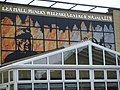
 Rugeley Foresters Jubilee Hall and Institute - geograph.org.uk - 3836019.jpg 1,600 × 1,064; 340 KB
-
 Rugeley from the air - geograph.org.uk - 4689102.jpg 640 × 480; 156 KB
-
 Rugeley Library - 12 Anson Street, Rugeley (33736167724).jpg 4,608 × 3,456; 6.36 MB
-
 Rugeley Library - 12 Anson Street, Rugeley (33768941833).jpg 4,608 × 3,456; 6.61 MB
-
 Rugeley Market Hall and Rugeley Bus Station - Elmore Lane, Rugeley (33761130873).jpg 4,608 × 3,456; 5.95 MB
-

-
 Rugeley Police Station - geograph.org.uk - 3554066.jpg 640 × 480; 52 KB
-
 Rugeley Telephone Exchange - geograph.org.uk - 3678943.jpg 838 × 1,251; 779 KB
-

-
 Rugeley Travelodge - geograph.org.uk - 3420737.jpg 640 × 480; 63 KB
-
 Rugeley War Memorial - geograph.org.uk - 3554065.jpg 640 × 480; 88 KB
-
 Rugeley, Staffordshire - geograph.org.uk - 3901791.jpg 4,000 × 3,000; 672 KB
-
 Sanders bridge sign.jpg 4,608 × 3,456; 5.66 MB
-
 Sandstone Rocks On Etching Hill - geograph.org.uk - 2055490.jpg 1,496 × 1,122; 636 KB
-
 Sandy Lane (A460) - geograph.org.uk - 3420710.jpg 640 × 480; 70 KB
-
 Sandy Lane Health Centre - geograph.org.uk - 4030424.jpg 4,608 × 2,977; 5.85 MB
-
 Sandy Lane Health Centre, Rugeley - geograph.org.uk - 3420706.jpg 640 × 480; 74 KB
-
 Sculptures, Forest Centre, Cannock Chase - geograph.org.uk - 90015.jpg 640 × 480; 132 KB
-
 Semi-detached houses in Rugeley - geograph.org.uk - 231341.jpg 640 × 481; 96 KB
-
 Semis on Hagley Road - geograph.org.uk - 3467451.jpg 1,142 × 857; 293 KB
-
 Service station, Rugeley - geograph.org.uk - 3420711.jpg 640 × 480; 70 KB
-
 Slitting Mill - Flickr - cattan2011.jpg 3,000 × 4,000; 1.94 MB
-
 Spring evening at The Chase - geograph.org.uk - 3467443.jpg 857 × 1,142; 349 KB
-
 Springfield Road Co-operative Supermarket (5927130584).jpg 3,888 × 2,592; 6.21 MB
-
 St John the Baptist - geograph.org.uk - 3483647.jpg 1,142 × 857; 394 KB
-
 St Paul's church - geograph.org.uk - 3469086.jpg 1,142 × 857; 221 KB
-
 St Paul's Church Hall, Rugeley - geograph.org.uk - 3473541.jpg 1,142 × 857; 306 KB
-
 St. John The Baptist, Slitting Mill - geograph.org.uk - 243548.jpg 640 × 480; 78 KB
-
 Startley Lane - geograph.org.uk - 681658.jpg 640 × 480; 129 KB
-
 Station Road roundabout, Rugeley - geograph.org.uk - 2726057.jpg 640 × 480; 52 KB
-
 Station Road, Rugeley - signs - Cannock Chase Heritage Trail (34493809696).jpg 4,608 × 3,456; 6.47 MB
-
 Stile Cop Road - geograph.org.uk - 4030419.jpg 4,608 × 3,456; 6.35 MB
-
 Sunlight and fog (Unsplash).jpg 4,288 × 2,848; 6.56 MB
-
 Tan Yard Bridge in Rugeley, Staffordshire - geograph.org.uk - 6393643.jpg 1,440 × 960; 1.27 MB
-

-

-

-
 Tesco Rugeley - geograph.org.uk - 3834230.jpg 1,600 × 1,064; 252 KB
-
 The A51 at Rugeley - geograph.org.uk - 6291504.jpg 4,032 × 3,024; 1.3 MB
-
 The Albion PH - geograph.org.uk - 3836056.jpg 1,600 × 1,064; 352 KB
-
 The Albion PH sign - geograph.org.uk - 3836071.jpg 1,064 × 1,600; 309 KB
-
 The Albion Pub, Rugeley - geograph.org.uk - 1948195.jpg 2,048 × 1,536; 593 KB
-
 The B5013 leaving Rugeley heading north - geograph.org.uk - 3792147.jpg 3,786 × 2,690; 3.43 MB
-
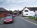
 The Britannia, Rugeley - geograph.org.uk - 1538181.jpg 640 × 472; 74 KB
-
 The car park field - geograph.org.uk - 5734417.jpg 640 × 480; 48 KB
-
 The Chase pub, Rugeley - geograph.org.uk - 3420749.jpg 640 × 509; 101 KB
-
 The Chase, Rugeley - geograph.org.uk - 2458503.jpg 640 × 428; 67 KB
-
 The Crown, Rugeley - geograph.org.uk - 1538167.jpg 480 × 640; 68 KB
-
 The Glen - geograph.org.uk - 682631.jpg 640 × 480; 102 KB
-
 The Horns, Slittingmill Road - geograph.org.uk - 3467138.jpg 1,142 × 857; 294 KB
-
 The Mossley Tavern - Armitage Road and The Mossley, Rugeley (33727461314).jpg 3,456 × 4,608; 5.76 MB
-
 The Mossley Tavern - Armitage Road and The Mossley, Rugeley (34529154716).jpg 4,608 × 3,456; 5.95 MB
-
 The Mossley Tavern - Armitage Road and The Mossley, Rugeley - pub sign (34439920341).jpg 3,456 × 4,608; 6.09 MB
-
 The Mossley Tavern - Armitage Road and The Mossley, Rugeley - road sign (34529162696).jpg 4,608 × 3,456; 3.11 MB
-
 The Mossley Tavern, Rugeley - geograph.org.uk - 1538179.jpg 640 × 480; 57 KB
-
 The new modern Rugeley fire station - geograph.org.uk - 4363904.jpg 4,128 × 2,322; 3.91 MB
-
 The Pear Tree - geograph.org.uk - 1521416.jpg 640 × 480; 198 KB
-
 The Pear Tree, Rugeley - geograph.org.uk - 843394.jpg 640 × 480; 59 KB
-
 The Pig and Bell in Rugeley, Staffordshire - geograph.org.uk - 6393803.jpg 1,280 × 960; 1.16 MB
-
 The Pig and Bell in Rugeley, Staffordshire - geograph.org.uk - 6393816.jpg 1,280 × 960; 1.06 MB
-
 The Pig and Bell Pub, Rugeley - geograph.org.uk - 1948215.jpg 2,048 × 1,536; 596 KB
-
 The Prince of Wales, Rugeley - geograph.org.uk - 1320141.jpg 640 × 480; 82 KB
-
 The Red Lion in Rugeley, Staffordshire - geograph.org.uk - 6393784.jpg 1,280 × 960; 1.16 MB
-
 The Red Lion in Rugeley, Staffordshire - geograph.org.uk - 6393787.jpg 1,280 × 960; 1.14 MB
-
 The Red Lion, Rugeley - geograph.org.uk - 843400.jpg 640 × 480; 68 KB
-
 The River Trent near Rugeley - geograph.org.uk - 4555143.jpg 1,024 × 844; 348 KB
-
 The River Trent, Rugeley - geograph.org.uk - 3554069.jpg 640 × 480; 57 KB
-
 The Shrew Pub, Rugeley - geograph.org.uk - 1948210.jpg 2,048 × 1,536; 588 KB
-
 The Stone House, Slitting Mill - geograph.org.uk - 836234.jpg 640 × 480; 325 KB
-
 The Thorns Inn, Slitting Mill - geograph.org.uk - 3420666.jpg 640 × 480; 58 KB
-

-
 The Vaults Pub, Rugeley - geograph.org.uk - 1948202.jpg 2,048 × 1,536; 616 KB
-
 The Vaults, Rugeley - geograph.org.uk - 3420720.jpg 640 × 480; 57 KB
-
 Track Near Rugeley - geograph.org.uk - 403195.jpg 640 × 480; 107 KB
-
 Trent & Mersey Canal - Rugeley - bridge 65 - The Mossley (34440311911).jpg 4,608 × 3,456; 6.48 MB
-
 Trent & Mersey Canal - Rugeley - steps (33727792424).jpg 3,456 × 4,608; 6.54 MB
-

-
 Trent & Mersey Canal - Rugeley -Winding Hole - sign - Please slow down (34408727692).jpg 4,608 × 3,456; 5.66 MB
-

-
 Trent and Mersey Canal at Brindley Bank, Rugeley - geograph.org.uk - 6165957.jpg 1,440 × 960; 1.68 MB
-
 Trent and Mersey Canal at Brindley Bank, Rugeley - geograph.org.uk - 6165960.jpg 960 × 1,280; 1.31 MB
-
 Trent and Mersey Canal at Brindley Bank, Rugeley - geograph.org.uk - 6393024.jpg 1,440 × 960; 1.44 MB
-
 Trent and Mersey Canal at Brindley Bank, Rugeley - geograph.org.uk - 6393034.jpg 1,440 × 960; 1.64 MB
-
 Trent and Mersey Canal in Rugeley, Staffordshire - geograph.org.uk - 6393662.jpg 1,600 × 900; 1.52 MB
-

-
 Trent and Mersey Canal north of Rugeley, Staffordshire - geograph.org.uk - 6012004.jpg 1,440 × 1,080; 1.89 MB
-

-
 Trent and Mersey Canal north of Rugeley, Staffordshire - geograph.org.uk - 6012018.jpg 1,280 × 1,280; 1.91 MB
-
 Try again^ - geograph.org.uk - 6393042.jpg 1,280 × 960; 1.51 MB
-
 Upper Birches Farm - geograph.org.uk - 3420693.jpg 1,024 × 555; 105 KB


.jpg)
.jpg)


.jpg)


.jpg)
.jpg)
.jpg)


_near_Rugeley,_Staffordshire_-_geograph.org.uk_-_5049384.jpg)


.jpg)

.jpg)


.jpg)


.jpg)
.jpg)
.jpg)
_approaching_Station_Road_roundabout_-_geograph.org.uk_-_2726052.jpg)


.jpg)
.jpg)
.jpg)
.jpg)


_-_geograph.org.uk_-_3420710.jpg)


.jpg)


.jpg)

.jpg)

.jpg)
.jpg)
.jpg)


.jpg)
.jpg)
.jpg)
.jpg)


.jpg)
.jpg)
.jpg)
.jpg)


