Category:Routemaster Close
Jump to navigation
Jump to search
| Object location | | View all coordinates using: OpenStreetMap |
|---|
Street in the London Borough of Newham _-_geograph.org.uk_-_3311945.jpg) | |||||
| Upload media | |||||
| Instance of | |||||
|---|---|---|---|---|---|
| Named after | |||||
| Location | London Borough of Newham, Greater London, London, England | ||||
| Connects with | |||||
 | |||||
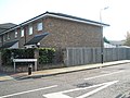
English: Routemaster Close is a street in Plaistow, London Borough of Newham named after the Routemaster bus. It is a cul-de-sac off of Greengate Street, part of the A112 road. It is part of a housing development that was built on the site of the garage building of West Ham bus garage, which opened in 1906 and closed in 1992. London Transport (Central Area) Routemasters were based there from 1959 until 1985.
Media in category "Routemaster Close"
The following 4 files are in this category, out of 4 total.
-
 A worthy recipient - geograph.org.uk - 1003583.jpg 640 × 480; 78 KB
-

-

-
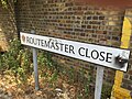 Routemaster Close sign.jpg 1,024 × 768; 252 KB

_-_geograph.org.uk_-_3311942.jpg)
