Category:Roscrea round tower
Jump to navigation
Jump to search

|
This object is indexed in the Archaeological Survey of Ireland under SMR No. TN012-010005-
Geographic information system of the National Monuments Service: Historic Environment Viewer – Database record. |
Round tower and National monument in Roscrea  | |||||
| Upload media | |||||
| Instance of | |||||
|---|---|---|---|---|---|
| Location | County Tipperary, Munster, Ireland | ||||
| Heritage designation | |||||
 | |||||
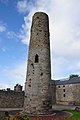
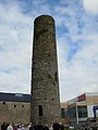
English: 12th-century round tower in Roscrea, County Tipperary, located across the surviving west gable of the Romanesque church. The tower was shortened by c. 6m after the 1798 rebellion as it has been used by snipers. (See entry 1843 in Jean Farrelly and Caimin O'Brien: Archaeological Inventory of County Tipperary: Vol. I – North Tipperary, ISBN 0-7557-1264-1.) National monument in state ownership #126.
Media in category "Roscrea round tower"
The following 9 files are in this category, out of 9 total.
-
 Monastic Tower.JPG 1,536 × 2,048; 712 KB
-
 Roscrea - Round Tower - geograph.org.uk - 1609590.jpg 426 × 640; 75 KB
-
 Roscrea Round Tower 2010 09 03.jpg 2,285 × 3,427; 4.53 MB
-
 Roscrea Round Tower and Church.jpg 1,500 × 2,122; 1.8 MB
-
 Roscrea tower.jpg 2,304 × 3,072; 1.1 MB
-
 Roscrea.jpg 1,424 × 2,144; 410 KB
-
 Round tower Roscrea.jpg 2,304 × 3,072; 1.1 MB
-
 The round tower, Roscrea - geograph.org.uk - 4629999.jpg 768 × 1,024; 100 KB
-
 Yew and west front of old St. Cronan's church - geograph.org.uk - 4630022.jpg 1,024 × 768; 217 KB


