Category:Road maps of Jordan
Jump to navigation
Jump to search
Media in category "Road maps of Jordan"
The following 15 files are in this category, out of 15 total.
-
 Map of the Safi-Aqaba Highway and nearby locations.jpg 460 × 476; 106 KB
-
 Route 10-HKJ-map.png 1,000 × 999; 18 KB
-
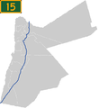 Route 15-HKJ-map.png 1,000 × 999; 23 KB
-
 Route 20-HKJ-map.png 1,000 × 999; 17 KB
-
 Route 25-HKJ-map.png 1,000 × 999; 18 KB
-
 Route 30-HKJ-map.png 1,000 × 999; 18 KB
-
 Route 35-HKJ-map.png 1,000 × 999; 18 KB
-
 Route 40-HKJ-map.png 1,000 × 999; 17 KB
-
 Route 5-HKJ-map.png 1,000 × 999; 18 KB
-
 Route 50-HKJ-map.png 1,000 × 999; 17 KB
-
 Route 55-HKJ-map.png 1,000 × 999; 17 KB
-
 Route 60-HKJ-map.png 1,000 × 999; 17 KB
-
 Route 65-HKJ-map.png 1,000 × 999; 18 KB
-
 Route 70-HKJ-map.png 1,000 × 999; 17 KB
-
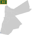 Route 80-HKJ-map.png 1,000 × 999; 17 KB


