Category:Rittergut Putzkau
Jump to navigation
Jump to search
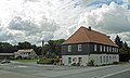
Deutsch: Ehem. Rittergut Oberputzkau, Ottendorfer Straße, mit Herrenhaus, Gesindehaus und Torhaus sowie Schornstein der ehem. Brauerei, siehe [1].
| (Wikidata) |
| Object location | | View all coordinates using: OpenStreetMap |
|---|
Media in category "Rittergut Putzkau"
The following 13 files are in this category, out of 13 total.
-
 Album der Rittergüter und Schlösser im Königreiche Sachsen III b 299.jpg 3,721 × 2,810; 3.63 MB
-

-
 Ober-Putzkau (Heise, 1850).jpg 2,786 × 2,092; 4.51 MB
-
 Putzkau-Rittergut--4-5.jpg 2,895 × 1,628; 2.31 MB
-
 Putzkau-Rittergut-3-4-5.jpg 4,052 × 1,688; 2.94 MB
-
 Putzkau-Rittergut-3-7.jpg 3,238 × 1,931; 2.04 MB
-
 Putzkau-Rittergut-3.jpg 3,351 × 1,885; 2.72 MB
-
 Putzkau-Rittergut-4-5.jpg 3,477 × 2,068; 2.62 MB
-
 Putzkau-Rittergut-5-W-.jpg 2,462 × 1,641; 1.26 MB
-
 Putzkau-Rittergut-5-W.jpg 1,819 × 1,819; 1.44 MB
-
 Putzkau-Rittergut-5.jpg 2,368 × 2,986; 2.36 MB
-
 Putzkau-Rittergut-7.jpg 3,435 × 1,932; 2.8 MB
-
 Rittergut Putzkau.jpg 4,000 × 3,000; 3.83 MB

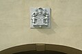
,_s%C3%BCdlicher_Wirtschaftsfl%C3%BCgel_mit_Gesindewohnhaus_(Nr._4),_Torhaus_mit_Wappen_(Nr._5,_6)_und_angrenzendes_Brauereigeb%C3%A4ude_mit_Schornstein_des_ehemaligen_Rittergutes_Ottendorfer_Stra%C3%9Fe_3,_4,_5,_6.jpg)
.jpg)


