Category:Rhauder Kirche
Jump to navigation
Jump to search
| Object location | | View all coordinates using: OpenStreetMap |
|---|
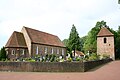
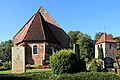
church building in Rhauderfehn, Germany  | |||||
| Upload media | |||||
| Instance of | |||||
|---|---|---|---|---|---|
| Made from material | |||||
| Location | Rhauderfehn, Leer, Lower Saxony, Germany | ||||
| Architectural style | |||||
| Heritage designation | |||||
 | |||||
Subcategories
This category has only the following subcategory.
I
Media in category "Rhauder Kirche"
The following 13 files are in this category, out of 13 total.
-
 ChurchRhaude.jpg 3,072 × 2,048; 3.54 MB
-
 Rhauderfehn Rhaude - Dorfstraße - Kirche + Friedhof 01 ies.jpg 5,616 × 3,744; 17.53 MB
-
 Rhauderfehn Rhaude - Dorfstraße - Kirche + Friedhof 02 ies.jpg 5,616 × 3,744; 21.11 MB
-
 Rhauderfehn Rhaude - Dorfstraße - Kirche + Friedhof 03 ies.jpg 5,616 × 3,744; 20.99 MB
-
 Rhauderfehn Rhaude - Dorfstraße - Kirche + Friedhof 04 ies.jpg 5,616 × 3,742; 21.53 MB
-
 Rhauderfehn Rhaude - Dorfstraße - Kirche + Friedhof 05 ies.jpg 5,616 × 3,744; 22.31 MB
-
 Rhauderfehn Rhaude - Dorfstraße - Kirche + Glockenturm + Friedhof 01 ies.jpg 5,616 × 3,744; 17.83 MB
-
 Rhauderfehn Rhaude - Dorfstraße - Kirche + Glockenturm + Friedhof 02 ies.jpg 5,616 × 3,744; 19.93 MB
-
 Rhauderfehn Rhaude - Dorfstraße - Kirche + Glockenturm + Friedhof 03 ies.jpg 5,616 × 3,744; 21.66 MB
-
 Rhauderfehn Rhaude - Dorfstraße - Kirche + Glockenturm + Friedhof 04 ies.jpg 5,616 × 3,746; 18.08 MB
-
 Rhauderfehn Rhaude - Dorfstraße - Kirche + Glockenturm + Friedhof 05 ies.jpg 5,616 × 3,744; 20.58 MB
-
 Rhauderfehn Rhaude - Dorfstraße - Kirche 01 ies.jpg 3,744 × 5,616; 20.03 MB
-
 Rhauderfehn Rhaude - Dorfstraße - Kirche 02 ies.jpg 3,744 × 5,616; 19.8 MB


Categories:
- Churches in Rhauderfehn
- Lutheran churches in Landkreis Leer
- 14th-century brick churches in Lower Saxony
- Churches in Kirchenkreis Rhauderfehn
- Brick churches in Landkreis Leer
- Romanogothic churches in Germany
- Cultural heritage monuments in Rhauderfehn
- Dorfkern Rhaude
- Supports by the European Union in Lower Saxony
- Verlässlich geöffnete Kirchen