Category:Rettungsschuppen (Am Bahnhof, Warnemünde)
Jump to navigation
Jump to search
| Object location | | View all coordinates using: OpenStreetMap |
|---|
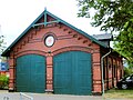
Deutsch: Der ehem. Rettungsschuppen der DGzRS von 1904, Warnemünde, Rostock, Mecklenburg
Media in category "Rettungsschuppen (Am Bahnhof, Warnemünde)"
The following 3 files are in this category, out of 3 total.
-
 Rostock Warnemuende Am Bahnhof 1e 2011-05-17.jpg 2,154 × 1,615; 2 MB
-
 Warnemuende DGzRS Rettungsschuppen Seenotrettungsstation 1.jpg 2,489 × 2,980; 1.64 MB
-
 Warnemuende DGzRS Rettungsschuppen Seenotrettungsstation.jpg 2,425 × 2,073; 1.33 MB


