Category:Reinheimer Hügelland
Jump to navigation
Jump to search
 | |||||
| Upload media | |||||
| Instance of | |||||
|---|---|---|---|---|---|
| Location |
| ||||
 | |||||
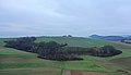
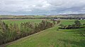
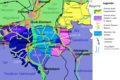
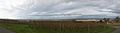
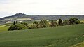
Deutsch: Das Reinheimer Hügelland bezeichnet eine größtenteils waldfreie Hügellandschaft, die naturräumlich zum Rhein-Main-Tiefland gehört und die Haupteinheit 231 darstellt. Es erstreckt sich von Roßdorf (bei Darmstadt) Richtung Süden über Reinheim bis nach Brensbach und von dort aus über Otzberg und Groß-Umstadt nordwärts bis nach Schaafheim. Der durchschnittliche Höhenbereich liegt zwischen 140 und 280 m ü. NHN.
Der Naturraum wird in vier Untereinheiten gegliedert:
- 231 Reinheimer Hügelland
- 231.0 Gersprenzgrund (8,99 km²)
- 231.1 Reinheimer Becken (100,01 km²)
- 231.2 Otzberger Randhügelland (16,36 km²)
- 231.3 Kleine Bergstraße (38,02 km²)
Subcategories
This category has the following 5 subcategories, out of 5 total.
F
N
O
R
Media in category "Reinheimer Hügelland"
The following 20 files are in this category, out of 20 total.
-
 Binnendüne bei Reinheim.JPG 4,896 × 3,672; 6.23 MB
-
 Blick ueber das Reinheimer Huegelland.jpg 3,456 × 2,304; 1.07 MB
-
 Breitenstein Otzberg1.jpg 5,261 × 3,006; 7.22 MB
-
 Breitenstein Schluchten.jpg 1,620 × 1,438; 1,017 KB
-
 Grossbieberau Reinheim Ueberau Gersprenz 25 SAM 0767 20200501.jpg 3,840 × 1,607; 1.63 MB
-
 Groß-Bieberau und NSG Forstberg.jpg 4,896 × 3,264; 3.25 MB
-
 Gräbenackersbach.jpg 5,472 × 3,078; 6.98 MB
-
 Hippelsbach Hundertmorgen.jpg 1,542 × 786; 658 KB
-
 Karte Reinheimer Hügelland.png 2,568 × 1,716; 1.64 MB
-
 Otzberg NE 360 GrossUmstadt SAM 0833 20200503.jpg 3,837 × 1,635; 1.83 MB
-
 Otzberg NW 280 Reinheim Hahn SAM 0848 20200503.jpg 3,840 × 1,768; 1.68 MB
-
 Panoram mit Blick zum Otzberg.png 2,444 × 1,112; 4 MB
-
 Panorama der Hügel bei Schaafheim.JPG 2,768 × 848; 1.18 MB
-
 Panorama Dieburger Bucht und Messeler Hügelland.JPG 4,832 × 1,328; 1.3 MB
-
 Panorama LK Darmstadt-Dieburg 9528560395 79167406d1 o.jpg 20,562 × 2,798; 15.24 MB
-
 Panoramablick Klein-Zimmern.png 981 × 220; 364 KB
-
 Reinheimer Huegelland, suedliche Reinheimer Buckel und Otzberg.jpg 2,318 × 1,303; 598 KB
-
 Reinheimer Hügelland, Reinheim, Nieder-Klingen, Otzberg.JPG 4,896 × 3,264; 3.79 MB
-
 Reinheimer Teich.jpg 1,280 × 853; 332 KB
-
 Wingertsberg.JPG 4,896 × 3,672; 5.94 MB


