Category:Regional data maps
Jump to navigation
Jump to search
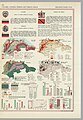
Small maps and graphics of the countries of the world appeared in the Pergamon World Atlas (1967). These maps and graphics refer to relief types, population, land use and economy. Along with the maps and graphics, there are flags, coats of arms and basic information of the countries.
Media in category "Regional data maps"
The following 46 files are in this category, out of 46 total.
-
 1967 data of Albania and Greece.jpg 2,169 × 2,888; 818 KB
-
 1967 data of Arabia, Iran and Afghanistan.jpg 3,960 × 2,900; 1.61 MB
-
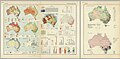 1967 data of Australia.jpg 5,831 × 2,880; 3.91 MB
-
 1967 data of Benelux.jpg 4,294 × 2,864; 2.89 MB
-
 1967 data of Burma, Thailand and Insulindia.jpg 3,960 × 2,896; 1.54 MB
-
 1967 data of Canada.jpg 3,956 × 2,880; 1.36 MB
-
 1967 data of Central America and the Caribbean.jpg 3,038 × 2,880; 2.14 MB
-
 1967 data of Central and Southern African countries.jpg 5,856 × 2,900; 2.34 MB
-
 1967 data of Cuba.jpg 1,776 × 1,483; 779 KB
-
 1967 data of Czechoslovakia.jpg 4,277 × 2,862; 2.97 MB
-
 1967 data of Denmark.jpg 1,007 × 2,486; 900 KB
-
 1967 data of East Germany.jpg 3,930 × 2,868; 1.22 MB
-
 1967 data of Eastern African countries.jpg 2,144 × 2,888; 911 KB
-
 1967 data of France.jpg 5,847 × 2,877; 4.48 MB
-
 1967 data of Iceland.jpg 1,787 × 1,109; 610 KB
-
 1967 data of Italy.jpg 5,867 × 2,895; 3.7 MB
-
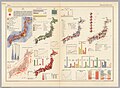 1967 data of Japan.jpg 3,948 × 2,896; 1.42 MB
-
 1967 data of Korea.jpg 2,142 × 2,888; 797 KB
-
 1967 data of Mexico.jpg 2,172 × 2,880; 829 KB
-
 1967 data of Mongolia and China - part 1.jpg 3,948 × 2,885; 1.34 MB
-
 1967 data of Mongolia and China - part 2.jpg 3,980 × 2,896; 1.23 MB
-
 1967 data of New Zealand.jpg 2,168 × 2,892; 642 KB
-
 1967 data of Northern African countries.jpg 3,912 × 2,896; 1.49 MB
-
 1967 data of Northern South America.jpg 1,991 × 2,879; 1.75 MB
-
 1967 data of Norway, Sweden and Finland.jpg 3,927 × 2,880; 1.56 MB
-
 1967 data of Poland - part 1.jpg 3,956 × 2,892; 1.39 MB
-
 1967 data of Poland - part 2.jpg 3,911 × 2,889; 1.45 MB
-
 1967 data of Romania and Bulgaria.jpg 3,899 × 2,860; 1.44 MB
-
 1967 data of South American countries.jpg 5,808 × 2,896; 2.55 MB
-
 1967 data of South Asia.jpg 3,897 × 2,886; 3.39 MB
-
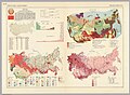 1967 data of Soviet Union - part 1.jpg 3,965 × 2,896; 1.47 MB
-
 1967 data of Soviet Union - part 2.jpg 3,955 × 2,888; 1.51 MB
-
 1967 data of Soviet Union - part 3.jpg 5,788 × 3,967; 5.49 MB
-
 1967 data of Spain and Portugal.jpg 4,320 × 2,879; 2.86 MB
-
 1967 data of Switzerland and Austria.jpg 3,948 × 2,892; 1.47 MB
-
 1967 data of the British Isles - part 1.jpg 4,292 × 2,872; 3.01 MB
-
 1967 data of the British Isles - part 2.jpg 3,948 × 2,873; 1.23 MB
-
 1967 data of Turkey, Cyprus and Middle Eastern countries.jpg 3,960 × 2,900; 1.42 MB
-
 1967 data of United States - part 1.jpg 4,303 × 2,895; 2.97 MB
-
 1967 data of United States - part 2.jpg 3,960 × 2,901; 1.36 MB
-
 1967 data of United States - part 3.jpg 3,936 × 2,920; 1.4 MB
-
 1967 data of Vietnam, Laos and Cambodia.jpg 1,967 × 2,888; 1.45 MB
-
 1967 data of West Germany.jpg 4,265 × 2,863; 2.85 MB
-
 1967 data of Western African countries.jpg 3,936 × 2,892; 1.58 MB
-
 1967 data of Yugoslavia and Hungary.jpg 3,952 × 2,896; 1.6 MB
-
 1967 information about European microstates.jpg 1,814 × 1,252; 779 KB


