Category:Redlingfield
Jump to navigation
Jump to search
English: Redlingfield is a village and civil parish in the Mid Suffolk district of Suffolk in eastern England. Located around six miles south-east of Diss, in 2005 its population was 110.[1]
village in the United Kingdom | |||||
| Upload media | |||||
| Instance of | |||||
|---|---|---|---|---|---|
| Location | Mid Suffolk, Suffolk, East of England, England | ||||
 | |||||
- ↑ Cite error: Invalid
<ref>tag; no text was provided for refs namedpopulation
Subcategories
This category has the following 4 subcategories, out of 4 total.
Media in category "Redlingfield"
The following 72 files are in this category, out of 72 total.
-
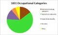 1831 occupational categories redlingfield.png 481 × 289; 10 KB
-
 A footbridge for a footpath - geograph.org.uk - 342619.jpg 640 × 480; 96 KB
-
 Abbotts Meadow sign - geograph.org.uk - 2703392.jpg 3,072 × 2,304; 1.55 MB
-
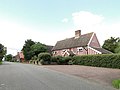
 Cottages - geograph.org.uk - 3779936.jpg 1,024 × 768; 189 KB
-
 Cut Mark Redlingfield St Andrews Church North Face - geograph.org.uk - 5511192.jpg 2,231 × 2,231; 4.19 MB
-
 Cut Mark Redlingfield St Andrews Church South East Face - geograph.org.uk - 5511197.jpg 2,231 × 2,231; 4.34 MB
-
 Derelict Old Building - geograph.org.uk - 3779943.jpg 768 × 1,024; 401 KB
-
 Door Of Old Barn - geograph.org.uk - 3780044.jpg 1,024 × 768; 335 KB
-
 Entering Redlingfield - geograph.org.uk - 3779923.jpg 1,024 × 768; 239 KB
-
 Entering Redlingfield on Church Road - geograph.org.uk - 2703390.jpg 3,072 × 2,304; 1.41 MB
-
 Entering Redlingfield on Woodlane Road - geograph.org.uk - 2703388.jpg 3,072 × 2,304; 1.29 MB
-
 Field entrance off Mill Road - geograph.org.uk - 2703398.jpg 3,072 × 2,304; 1.51 MB
-
 Footpath - geograph.org.uk - 2432936.jpg 1,600 × 1,200; 503 KB
-
 Footpath - geograph.org.uk - 2432943.jpg 1,200 × 1,600; 892 KB
-
 Footpath - geograph.org.uk - 3780026.jpg 1,024 × 768; 191 KB
-
 Footpath to Horham ^ Southolt Roads - geograph.org.uk - 2707918.jpg 3,072 × 2,304; 1.45 MB
-
 Footpath to Horham ^ Southolt Roads - geograph.org.uk - 2707934.jpg 3,072 × 2,304; 1.39 MB
-
 Footpath to Southolt Road - geograph.org.uk - 2707985.jpg 2,640 × 1,980; 1.01 MB
-
 Green Farm, Redlingfield - geograph.org.uk - 2041767.jpg 640 × 480; 66 KB
-
 Green Lane - geograph.org.uk - 2707929.jpg 3,072 × 2,304; 1.35 MB
-
 Green Lane - geograph.org.uk - 2707973.jpg 3,072 × 2,304; 1.39 MB
-
 Green Lane - geograph.org.uk - 2708090.jpg 3,072 × 2,304; 1.32 MB
-
 Kiln Farm sign - geograph.org.uk - 2703868.jpg 3,072 × 2,304; 1.53 MB
-
 Low Road, Redlingfield - geograph.org.uk - 2708093.jpg 2,640 × 1,980; 1.2 MB
-
 Low Road, Redlingfield - geograph.org.uk - 2708345.jpg 3,072 × 2,304; 1.65 MB
-
 Low Road, Redlingfield - geograph.org.uk - 2708347.jpg 3,072 × 2,304; 1.63 MB
-
 Low Road, Redlingfield - geograph.org.uk - 2708348.jpg 3,072 × 2,304; 1.6 MB
-
 Mill Road - geograph.org.uk - 1055113.jpg 3,072 × 2,304; 1.46 MB
-
 Mill Road, Redlingfield - geograph.org.uk - 2703391.jpg 3,072 × 2,304; 1.47 MB
-
 Mill Road, Redlingfield - geograph.org.uk - 2703393.jpg 3,072 × 2,304; 1.25 MB
-
 Mill Road, Redlingfield - geograph.org.uk - 2703396.jpg 3,072 × 2,304; 1.26 MB
-
 Mill Road, Redlingfield - geograph.org.uk - 2703397.jpg 3,072 × 2,304; 1.65 MB
-
 Mill Road, Redlingfield - geograph.org.uk - 2703458.jpg 3,072 × 2,304; 1.33 MB
-
 Muddy Footpath - geograph.org.uk - 3780034.jpg 1,024 × 768; 193 KB
-
 Needs A Clean - geograph.org.uk - 3779934.jpg 768 × 1,024; 261 KB
-
 Occold Road, Redlingfield - geograph.org.uk - 2703395.jpg 3,072 × 2,304; 1.35 MB
-
 Occold Road, Redlingfield - geograph.org.uk - 2703459.jpg 3,072 × 2,304; 1.5 MB
-
 Occold Road, Redlingfield - geograph.org.uk - 2703861.jpg 3,072 × 2,304; 1.32 MB
-
 Old Barn - geograph.org.uk - 3780042.jpg 1,024 × 768; 261 KB
-
 Old Barn - geograph.org.uk - 3780050.jpg 1,024 × 768; 317 KB
-
 Old cart sheds - geograph.org.uk - 2041775.jpg 640 × 480; 88 KB
-
 Old Name Plaque - geograph.org.uk - 3780046.jpg 1,024 × 768; 281 KB
-
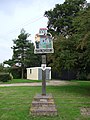
 Old Village Sign - geograph.org.uk - 3779951.jpg 768 × 1,024; 187 KB
-
 Park Road - geograph.org.uk - 2697229.jpg 3,072 × 2,304; 1.28 MB
-
 Pear Tree Cottages - geograph.org.uk - 2707979.jpg 3,072 × 2,304; 1.42 MB
-
 Pink house at Redlingfield, Suffolk - geograph.org.uk - 2041987.jpg 640 × 480; 46 KB
-
 Redlingfield Hall, Suffolk - geograph.org.uk - 2041737.jpg 640 × 480; 102 KB
-
 Redlingfield Road - geograph.org.uk - 1055107.jpg 3,072 × 2,304; 1.51 MB
-
 Redlingfield village sign - geograph.org.uk - 4294757.jpg 480 × 640; 193 KB
-
 Remembered with Honour - geograph.org.uk - 5237705.jpg 2,592 × 1,944; 2.95 MB
-
 Roadsign at The Knoll, Redlingfield - geograph.org.uk - 2672191.jpg 2,304 × 3,072; 1.65 MB
-
 Roadsign on Green Lane, Redlingfield - geograph.org.uk - 2708344.jpg 2,304 × 3,072; 1.6 MB
-
 Roadsign on Mill Road - geograph.org.uk - 2703394.jpg 2,304 × 3,072; 1.47 MB
-
 Telephone Box ^ The Knoll Victorian Postbox - geograph.org.uk - 2672187.jpg 3,072 × 2,304; 1.53 MB
-
 The entrance to Kiln Farm - geograph.org.uk - 2703863.jpg 3,072 × 2,304; 1.63 MB
-
 The Knoll Victorian Postbox - geograph.org.uk - 2672188.jpg 2,304 × 3,072; 1.64 MB
-
 The Knoll Victorian Postbox - geograph.org.uk - 2672190.jpg 2,304 × 3,072; 1.66 MB
-
 The old and the new - geograph.org.uk - 2041752.jpg 640 × 480; 95 KB
-
 Thorley's Cake - geograph.org.uk - 2041745.jpg 640 × 480; 76 KB
-
 Victorian postbox at Redlingfield - geograph.org.uk - 2041759.jpg 480 × 640; 104 KB
-
 Wattle And Daub - geograph.org.uk - 3780045.jpg 768 × 1,024; 310 KB
-
 Woodlane Road - geograph.org.uk - 2697222.jpg 3,072 × 2,304; 1.26 MB
-
 Woodlane Road - geograph.org.uk - 3780016.jpg 1,024 × 768; 269 KB
-
 Woodlane Road, Redlingfield - geograph.org.uk - 2703389.jpg 3,072 × 2,304; 1.34 MB
-
 Z Bend in a country lane - geograph.org.uk - 2041679.jpg 640 × 480; 71 KB
-
 A house at Shingle Hill Corner - geograph.org.uk - 349293.jpg 640 × 432; 58 KB
-
 Footpath - geograph.org.uk - 342606.jpg 640 × 480; 105 KB
-

-
 Part of Kiln Farm - geograph.org.uk - 349315.jpg 640 × 417; 99 KB
-
 Road to Denham Hall Farm - geograph.org.uk - 349305.jpg 640 × 435; 92 KB
-
 Track to Whitehouse Farm - geograph.org.uk - 342592.jpg 640 × 480; 75 KB
-
 Woodlane Road - geograph.org.uk - 354172.jpg 640 × 377; 38 KB


