Category:Rathaus Plauen, Dresden
Jump to navigation
Jump to search
| Object location | | View all coordinates using: OpenStreetMap |
|---|
building in Dresden, Saxony, Germany   | |||||
| Upload media | |||||
| Instance of | |||||
|---|---|---|---|---|---|
| Location | Dresden, Saxony, Germany | ||||
| Heritage designation | |||||
| Inception |
| ||||
| Date of official opening |
| ||||
 | |||||
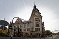
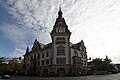
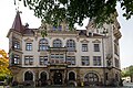
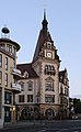
Deutsch: Rathaus Plauen (Nöthnitzer Straße 2) am F.-C.-Weiskopf-Platz in Dresden-Plauen. Heute Sitz des Ortsamtes Plauen
Media in category "Rathaus Plauen, Dresden"
The following 27 files are in this category, out of 27 total.
-
 19830930100AR Dresden Bestand für Exbau WBS 14.40 Müllerbunnen.jpg 2,221 × 2,850; 1.59 MB
-
 19830930240AR Dresden Bestand für Exbau WBS 14.40 Müllerbunnen.jpg 2,854 × 1,965; 2.69 MB
-
 20061116030MDR Dresden-Plauen Rathaus Nöthnitzer Straße 2.jpg 2,295 × 2,864; 4.7 MB
-
 20061116035DR Dresden-Plauen Rathaus Nöthnitzer Straße 2.jpg 1,641 × 2,524; 3.56 MB
-
 20061116040DR Dresden-Plauen Rathaus Nöthnitzer Straße 2.jpg 1,769 × 2,364; 3.99 MB
-
 20061116045DR Dresden-Plauen Rathaus Nöthnitzer Straße 2.jpg 2,494 × 1,881; 3.25 MB
-
 2021101902 Rathaus Dresden-Plauen Eckansicht Chemnitzer Strasse.jpg 5,231 × 3,487; 11.65 MB
-
 2021101903 Rathaus Dresden-Plauen Eckansicht links.jpg 6,016 × 4,000; 6.74 MB
-
 2021101904 Rathaus Dresden-Plauen Eckansicht Noethnitzer Strasse.jpg 6,016 × 4,000; 14.09 MB
-
 2021101905 Rathaus Dresden-Plauen Eckansicht und Cirrocumuluswolken.jpg 6,016 × 4,000; 6.3 MB
-
 2021101907 Rathaus Dresden-Plauen links.jpg 6,016 × 4,000; 9.46 MB
-
 20240125.Rathaus Plauen.-01.jpg 4,624 × 3,468; 7.28 MB
-
 20240125.Rathaus Plauen.-02.jpg 4,624 × 3,468; 7.15 MB
-
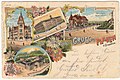 Ansichtskarte Plauen bei Dresden 1904.jpg 1,600 × 1,064; 781 KB
-
 Dresden, Nöthnitzer Straße 2, Bürgerbüro Plauen, 17.6.2.40-050026.jpg 1,668 × 2,500; 397 KB
-
 Dresden-Plauen-Rathaus.jpg 1,113 × 1,812; 297 KB
-
 Mosaik-Nöthnitzer2-DD.jpg 2,048 × 1,279; 684 KB
-
 Nöthnitzer Straße 2 Dresden-Plauen.JPG 3,232 × 3,232; 3.15 MB
-
 Rathaus Dresden Plauen, Deckenbemalung 2.jpg 2,448 × 3,264; 1.7 MB
-
 Rathaus Dresden Plauen, Deckenbemalung 3.jpg 3,264 × 2,448; 2.05 MB
-
 Rathaus Dresden Plauen, Deckenbemalung 4.jpg 3,264 × 2,448; 1.52 MB
-
 Rathaus Dresden Plauen, Deckenbemalung 5.jpg 3,264 × 2,448; 2.19 MB
-
 Rathaus Dresden Plauen, Deckenbemalung 6.jpg 4,032 × 3,024; 6.67 MB
-
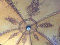 Rathaus Dresden Plauen, Deckenbemalung.jpg 3,264 × 2,448; 1.71 MB
-
 RathausPlauen-DD.jpg 1,360 × 2,048; 450 KB
-
 StGeorgPlauen-DD.jpg 1,332 × 1,965; 533 KB
-
 Türverzierung Rathaus Dresden Plauen.jpg 2,448 × 3,264; 2.74 MB


