Category:Rahlstedter Dorfplatz
Jump to navigation
Jump to search
| Object location | | View all coordinates using: OpenStreetMap |
|---|
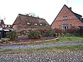
Deutsch: Der Rahlstedter Dorfplatz befindet sich südlich und nördlich der Stapelfelder Straße im Stadtteil Rahlstedt im Bezirk Hamburg-Wandsbek. Medien in dieser Kategorie zeigen den südlichen Teil auf Höhe der Stapelfelder Straße Nr. 28, einem denkmalgeschützten Ensemble bestehend aus mehreren Gebäuden, Hofanlagen und Wohnwirtschaftsgebäuden – teilweise aus dem 19. Jahrhundert.
This is the category for an architectural monument.
It is on the list of cultural monuments of Hamburg, no. 31108.
It is on the list of cultural monuments of Hamburg, no. 31108.
square in Hamburg, Germany | |||||
| Upload media | |||||
| Instance of | |||||
|---|---|---|---|---|---|
| Location | Rahlstedt, Wandsbek, Hamburg, Germany | ||||
 | |||||
Media in category "Rahlstedter Dorfplatz"
The following 21 files are in this category, out of 21 total.
-
 763 rahlstedter dorfplatz 10.jpg 4,272 × 2,848; 3.45 MB
-
 764 klettenstieg 2 a-d.jpg 4,272 × 2,848; 3.3 MB
-
 Rahlstedter Dorfplatz 10 in Hamburg-Rahlstedt.jpg 4,504 × 3,378; 6.57 MB
-
 Rahlstedter Dorfplatz 10-12 Ensembele in Hamburg-Rahlstedt.jpg 4,504 × 3,378; 7.44 MB
-
 Rahlstedter Dorfplatz 12 in Hamburg-Rahlstedt.jpg 4,504 × 3,378; 11.01 MB
-
 Rahlstedter Dorfplatz 12 und Nebengebäude in Hamburg-Rahlstedt.jpg 4,608 × 3,456; 8.06 MB
-
 Rahlstedter Dorfplatz 2a-c in Hamburg-Rahlstedt.jpg 4,504 × 3,378; 7.76 MB
-
 Rahlstedter Dorfplatz 4 in Hamburg-Rahlstedt mit Tor.jpg 4,504 × 3,378; 8.02 MB
-
 Rahlstedter Dorfplatz 8 Hofanlage in Hamburg-Rahlstedt.jpg 4,608 × 3,456; 9.27 MB
-
 Rahlstedter Dorfplatz 8 Nebengebäude in Hamburg-Rahlstedt.jpg 4,504 × 3,378; 6.46 MB
-
 Rahlstedter Dorfplatz in Hamburg-Rahlstedt.jpg 4,608 × 3,456; 8.72 MB
-
 Rahlstedter Dorfplatz mit historischen Bauernhäusern.jpg 4,504 × 3,378; 10.84 MB
-
 Ralstedter Dorfplatz 4 in Hamburg-Rahlstedt mit Fußweg Klettenstieg.jpg 4,608 × 3,456; 7.19 MB
-
 Stapelfelder Straße 28 (Hamburg-Rahlstedt).ajb.jpg 4,288 × 2,848; 6.34 MB
-
 Stapelfelder Straße 28 Ensemble Rahlstedter Dorfplatz in Hamburg-Rahlstedt (3).jpg 4,608 × 3,456; 8.83 MB
-
 Stapelfelder Straße 28 Ensemble Rahlstedter Dorfplatz in Hamburg-Rahlstedt (4).jpg 4,406 × 3,304; 7.34 MB
-
 Stapelfelder Straße 28a Ensemble Rahlstedter Dorfplatz in Hamburg-Rahlstedt.jpg 4,313 × 3,234; 8.11 MB
-
 Stapelfelder Straße 28a-d Ensemble Rahlstedter Dorfplatz in Hamburg-Rahlstedt (1).jpg 4,608 × 3,456; 8.93 MB
-
 Stapelfelder Straße 28a-d Ensemble Rahlstedter Dorfplatz in Hamburg-Rahlstedt (2).jpg 4,504 × 3,378; 9.24 MB
-
 Stapelfelder Straße 28b Ensemble Rahlstedter Dorfplatz in Hamburg-Rahlstedt (2).jpg 4,608 × 3,456; 8.09 MB
-
 Stapelfelder Straße 28b Ensemble Rahlstedter Dorfplatz in Hamburg-Rahlstedt.jpg 4,608 × 3,456; 8.06 MB


.ajb.jpg)
.jpg)
.jpg)

.jpg)
.jpg)
.jpg)
