Category:Raadhuis Oisterwijk
Jump to navigation
Jump to search
| Object location | | View all coordinates using: OpenStreetMap |
|---|
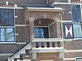
Nederlands: Afbeeldingen van het Raadhuis Oisterwijk, De Lind 56, 5061 HX Oisterwijk. Gelegen in een deel van de straat De Lind in de gemeente Oisterwijk in de provincie Noord-Brabant in het zuiden van Nederland. Het is een rijksmonument
|
This is a category about rijksmonument number 519976
|
 | |||||
| Upload media | |||||
| Instance of | |||||
|---|---|---|---|---|---|
| Location | Oisterwijk, North Brabant, Netherlands | ||||
| Street address |
| ||||
| Located on street | |||||
| Heritage designation |
| ||||
 | |||||
Media in category "Raadhuis Oisterwijk"
The following 12 files are in this category, out of 12 total.
-
 519976 Gemeentehuis Oisterwijk.jpg 4,990 × 4,051; 12.54 MB
-
 De Lind 56, Oisterwijk.jpg 6,000 × 4,000; 7.05 MB
-
 Detail Raadhuis Oisterwijk P1620457.jpg 4,000 × 3,000; 5.8 MB
-
 Detail Raadhuis Oisterwijk P1620458.jpg 4,000 × 3,000; 5.66 MB
-
 Detail Raadhuis Oisterwijk P1620459.jpg 4,000 × 3,000; 6.11 MB
-
 Raadhuis en Lindeboom P1620441 copy.jpg 1,928 × 1,312; 1.06 MB
-
 Raadhuis en Lindeboom P1620452 copy.jpg 3,598 × 2,797; 2.69 MB
-
 Raadhuis Oisterwijk P1040914.JPG 2,448 × 3,264; 3.7 MB
-
 Raadhuis Oisterwijk P1040915.JPG 3,264 × 2,448; 3.81 MB
-
 Raadhuis Oisterwijk P1620452.jpg 4,000 × 3,000; 6.32 MB
-
 Raadhuis Oisterwijk P1620454.jpg 4,000 × 3,000; 6.17 MB
-
 Raadhuis Oisterwijk P1620461.jpg 4,000 × 3,000; 6.64 MB


