Category:Raadhuis Gemert
Jump to navigation
Jump to search
| Object location | | View all coordinates using: OpenStreetMap |
|---|
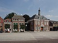
Nederlands: Afbeeldingen van het Gemeentehuis/Raadhuis van Gemert, Ridderplein 1, 5421 CV Gemert. Gelegen in Gemert, behorende tot de gemeente Gemert-Bakel, in de provincie Noord-Brabant in het zuiden van Nederland
|
This is a category about a municipal monument in Gemert-Bakel with number wikinr.99 |
Media in category "Raadhuis Gemert"
The following 4 files are in this category, out of 4 total.
-
 1652wikinr99 Raadhuis Gemert.jpg 4,240 × 3,133; 7.41 MB
-
 Raadhuis Gemert P1050893.JPG 2,448 × 3,264; 3.7 MB
-
 Raadhuis Gemert P1050921.JPG 2,448 × 3,264; 3.71 MB
-
 Raadhuis Gemert P1050922.JPG 2,448 × 3,264; 3.25 MB


