Category:Queen Avenue, Liverpool
Jump to navigation
Jump to search
| Object location | | View all coordinates using: OpenStreetMap |
|---|
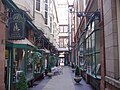
Queen Avenue is an L-shaped street connecting Dale Street and Castle Street, Liverpool. Most its buildings are Grade II listed by Historic England including a small iron gate into Sweeting Street. The Royal Insurance Building at Nos. 18 & 16 is II* listed.
Subcategories
This category has the following 6 subcategories, out of 6 total.
1
2
5
Media in category "Queen Avenue, Liverpool"
The following 14 files are in this category, out of 14 total.
-
 Entrance to Queen Avenue, Castle Street.jpg 4,717 × 2,925; 7.47 MB
-
 Queen Avenue 1.jpg 1,488 × 1,984; 429 KB
-
 Queen Avenue from Castle Street 2.jpg 3,207 × 4,780; 7.81 MB
-
 Queen Avenue from Dale Street 1.jpg 4,836 × 3,288; 7.84 MB
-
 Queen Avenue from Dale Street 2.jpg 4,974 × 3,270; 7.9 MB
-
 Queen Avenue from Sweeting Street.jpg 3,051 × 4,347; 6.12 MB
-
 Queen Avenue July 30 2010 (1).jpg 3,072 × 2,304; 1.2 MB
-
 Queen Avenue July 30 2010.jpg 2,304 × 3,072; 1.16 MB
-
 Queen Avenue to Castle Street.jpg 3,126 × 4,899; 8.29 MB
-
 Queen Avenue towards Exchange Street East 1.jpg 5,032 × 3,330; 8.15 MB
-
 Queen Avenue towards Exchange Street East 2.jpg 3,119 × 4,011; 5.41 MB
-
 Queen Avenue towards Exchange Street East 3.jpg 4,794 × 3,276; 7.4 MB
-
 Queen Avenue, Liverpool (1).jpg 1,280 × 960; 600 KB
-
 Queen Avenue, Liverpool (2).jpg 960 × 1,280; 583 KB


.jpg)


.jpg)
.jpg)
Categories:
- Streets in Liverpool City Centre
- Streets in Liverpool by name
- Liverpool Commercial District
- Streets called avenues
- Roads and streets named after women in Liverpool
- Roads and streets named after monarchs in the United Kingdom
- Things named after Anne of Great Britain
- Castle Street, Liverpool
- Dale Street, Liverpool