Category:Public footpaths in Stanley, West Yorkshire
Jump to navigation
Jump to search
Media in category "Public footpaths in Stanley, West Yorkshire"
The following 62 files are in this category, out of 62 total.
-
 A footpath leading to Lofthouse Gate - geograph.org.uk - 2762376.jpg 800 × 600; 130 KB
-
 A footpath leading to Lofthouse Gate - geograph.org.uk - 2762382.jpg 800 × 600; 126 KB
-
 Detour off the towpath - geograph.org.uk - 1828814.jpg 640 × 480; 384 KB
-
 Fenced path, Smalley Bight farm (1) - geograph.org.uk - 2468124.jpg 768 × 1,024; 546 KB
-
 Fenced path, Smalley Bight farm (2) - geograph.org.uk - 2468138.jpg 1,024 × 768; 793 KB
-
 Fenced path, Smalley Bight farm (3) - geograph.org.uk - 2468159.jpg 768 × 1,024; 718 KB
-
 Fenced path, Smalley Bight farm (4) - geograph.org.uk - 2468174.jpg 1,024 × 768; 743 KB
-
 Fenced path, Smalley Bight farm (5) - geograph.org.uk - 2468187.jpg 768 × 1,024; 798 KB
-
 Footbridge over unnamed stream - geograph.org.uk - 1832799.jpg 640 × 480; 361 KB
-
 Footpath - Aberford Road - geograph.org.uk - 4008462.jpg 480 × 640; 117 KB
-
 Footpath - Aberford Road - geograph.org.uk - 4321556.jpg 480 × 640; 96 KB
-
 Footpath - Aberford Road - geograph.org.uk - 4321559.jpg 480 × 640; 87 KB
-
 Footpath - Aberford Road - geograph.org.uk - 4321566.jpg 480 × 640; 80 KB
-
 Footpath - Aberford Road - geograph.org.uk - 4321733.jpg 480 × 640; 96 KB
-
 Footpath - Aberford Road - geograph.org.uk - 759964.jpg 555 × 640; 92 KB
-
 Footpath - Broadmeadows - geograph.org.uk - 3805320.jpg 480 × 640; 114 KB
-
 Footpath - Clifton Avenue - geograph.org.uk - 4030939.jpg 640 × 480; 92 KB
-
 Footpath - Ferry Lane - geograph.org.uk - 4008640.jpg 480 × 640; 139 KB
-
 Footpath - geograph.org.uk - 1832972.jpg 480 × 640; 370 KB
-
 Footpath - geograph.org.uk - 1832980.jpg 480 × 640; 397 KB
-
 Footpath - Lake Lock Drive - geograph.org.uk - 4321749.jpg 480 × 640; 78 KB
-
 Footpath - Lake Lock Drive - geograph.org.uk - 4321751.jpg 480 × 640; 96 KB
-
 Footpath - Lee Moor Road - geograph.org.uk - 4039366.jpg 480 × 640; 130 KB
-
 Footpath - Mount Road - geograph.org.uk - 4321807.jpg 480 × 640; 95 KB
-
 Footpath - off Aberford Road - geograph.org.uk - 4008876.jpg 480 × 640; 97 KB
-
 Footpath - viewed from Ridings Lane - geograph.org.uk - 3680178.jpg 640 × 480; 99 KB
-
 Footpath near Clark Hall - Aberford Road - geograph.org.uk - 759957.jpg 556 × 640; 104 KB
-
 Footpath off Bottom Boat Lane - geograph.org.uk - 2013431.jpg 1,024 × 768; 216 KB
-
 Footpath off Rook's Nest Road - geograph.org.uk - 5654618.jpg 1,024 × 683; 264 KB
-
 Footpath to Ash Crescent, Stanley - geograph.org.uk - 3885307.jpg 1,024 × 768; 146 KB
-
 Footpath to the river - geograph.org.uk - 2935297.jpg 1,024 × 768; 231 KB
-
 Footpath towards Lee Moor - geograph.org.uk - 2740821.jpg 640 × 480; 130 KB
-
 Footpath, Southern Washlands - geograph.org.uk - 2797343.jpg 1,024 × 768; 857 KB
-
 Footpath, Trans Pennine Trail - geograph.org.uk - 1833034.jpg 480 × 640; 395 KB
-
 Gate and path off Ferry Lane - geograph.org.uk - 5660176.jpg 1,024 × 683; 435 KB
-
 House near Trans Pennine Trail - geograph.org.uk - 1833062.jpg 640 × 480; 320 KB
-

-
 Park Lodge Lane - geograph.org.uk - 1501058.jpg 480 × 640; 129 KB
-

-
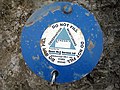 Pollution monitor detail - geograph.org.uk - 2464487.jpg 640 × 480; 319 KB
-
 Pollution monitors - geograph.org.uk - 2464481.jpg 1,024 × 768; 886 KB
-
 Public footpath - geograph.org.uk - 1837970.jpg 480 × 640; 336 KB
-
 Public Footpath - geograph.org.uk - 2358052.jpg 768 × 1,024; 836 KB
-
 Section of the old tram road, TPT 67 (1) - geograph.org.uk - 2294884.jpg 480 × 640; 127 KB
-
 Section of the old tram road, TPT 67 (2) - geograph.org.uk - 2294896.jpg 480 × 640; 145 KB
-
 Section of the old tram road, TPT 67 - geograph.org.uk - 2202535.jpg 768 × 1,024; 1,013 KB
-
 Swollen River Calder (5) - geograph.org.uk - 3033365.jpg 768 × 1,024; 965 KB
-
 The Trans Pennine trail. - geograph.org.uk - 5976534.jpg 1,024 × 683; 262 KB
-
 TPT Jungle^ - geograph.org.uk - 2468217.jpg 768 × 1,024; 862 KB
-
 TPT67 signpost - geograph.org.uk - 2470546.jpg 1,024 × 768; 584 KB
-
 Track - Bottom Boat Road - geograph.org.uk - 4321573.jpg 640 × 480; 131 KB
-
 Track - Bottom Boat Road - geograph.org.uk - 4321722.jpg 640 × 480; 101 KB
-
 Track - geograph.org.uk - 1277859.jpg 480 × 640; 387 KB
-
 Track - Sheridan Street - geograph.org.uk - 3805472.jpg 640 × 480; 113 KB
-
 Track into dangerous land - geograph.org.uk - 2015390.jpg 1,024 × 768; 181 KB
-
 Track to Langley Farm - geograph.org.uk - 1877487.jpg 480 × 640; 382 KB
-
 Unsigned footpath (1) - geograph.org.uk - 2402502.jpg 768 × 1,024; 698 KB
-
 Unsigned footpath (5) - geograph.org.uk - 2402521.jpg 1,024 × 768; 660 KB
-
 Walking group - geograph.org.uk - 1832843.jpg 480 × 640; 397 KB
-
 Walking group - geograph.org.uk - 1832865.jpg 480 × 640; 334 KB
-
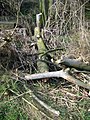
 Wind damage, broken branch - geograph.org.uk - 2358042.jpg 768 × 1,024; 1,008 KB
-
 Wind damage, smashed tree - geograph.org.uk - 2358033.jpg 480 × 640; 144 KB


_-_geograph.org.uk_-_2468124.jpg)
_-_geograph.org.uk_-_2468138.jpg)
_-_geograph.org.uk_-_2468159.jpg)
_-_geograph.org.uk_-_2468174.jpg)
_-_geograph.org.uk_-_2468187.jpg)


_-_geograph.org.uk_-_2294884.jpg)
_-_geograph.org.uk_-_2294896.jpg)

_-_geograph.org.uk_-_3033365.jpg)


_-_geograph.org.uk_-_2402502.jpg)
_-_geograph.org.uk_-_2402521.jpg)


