Category:Protestant Church (Stadtschlaining)
Jump to navigation
Jump to search
| Object location | | View all coordinates using: OpenStreetMap |
|---|
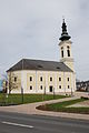
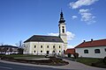
Deutsch: Evangelische Pfarrkirche Schlaining
church building in Stadtschlaining, Austria  Protestant church in Stadtschlaining | |||||
| Upload media | |||||
| Instance of | |||||
|---|---|---|---|---|---|
| Location | Stadtschlaining, Oberwart District, Burgenland, Austria | ||||
| Street address |
| ||||
| Heritage designation | |||||
 | |||||
Subcategories
This category has only the following subcategory.
K
Media in category "Protestant Church (Stadtschlaining)"
The following 13 files are in this category, out of 13 total.
-
 Evang pfarrkirche schlaining.JPG 2,592 × 3,872; 3.32 MB
-
 Evang schlaining.JPG 2,592 × 3,872; 3.15 MB
-
 Evangelische Pfarrkirche Stadtschlaining.jpg 4,624 × 3,468; 1.15 MB
-
 EvangKircheStadtschlainingBeschreibung.jpg 4,752 × 3,168; 6.44 MB
-
 EvangKircheStadtschlainingBezeichnung.jpg 4,752 × 3,168; 4.16 MB
-
 EvangKircheStadtschlainingBlickZumAltar.jpg 4,752 × 3,168; 5.75 MB
-
 EvangKircheStadtschlainingKindertisch.jpg 4,752 × 3,168; 6.28 MB
-
 EvangPfarrhofStadtschlaining.jpg 3,168 × 4,752; 5.7 MB
-
 KriegerdenkmalBeiDerEvangKirche.jpg 3,168 × 4,752; 6.23 MB
-
 Protestant Church Stadtschlaining.JPG 6,000 × 4,000; 14.52 MB
-
 Stadtschlaining - evang. Kirche.JPG 4,050 × 3,275; 9.7 MB
-
 Stadtschlaining evang kirche.JPG 3,872 × 2,592; 3.08 MB
-
 Stadtschlaining17.JPG 2,048 × 1,536; 784 KB


