Category:Proposed or planned infrastructure in London
Jump to navigation
Jump to search
Wikimedia category | |||||
| Upload media | |||||
| Instance of | |||||
|---|---|---|---|---|---|
| Category combines topics | |||||
| London | |||||
capital and largest city of England and the United Kingdom     .svg)   | |||||
| Pronunciation audio | |||||
| Instance of |
| ||||
| Location |
| ||||
| Located in or next to body of water | |||||
| Official language | |||||
| Head of government |
| ||||
| Inception |
| ||||
| Significant event |
| ||||
| Highest point |
| ||||
| Population |
| ||||
| Area |
| ||||
| Elevation above sea level |
| ||||
| Replaces | |||||
| IATA airport code |
| ||||
| Different from | |||||
| official website | |||||
 | |||||
Subcategories
This category has the following 9 subcategories, out of 9 total.
Media in category "Proposed or planned infrastructure in London"
The following 63 files are in this category, out of 63 total.
-
-
 (A) EDWARD OGLES' PLAN.jpg 3,189 × 2,333; 3.06 MB
-
 (C) CORPORATION SCHEME.jpg 2,933 × 2,087; 2.5 MB
-
 (D) WYATT'S PLAN.jpg 2,927 × 2,167; 2.77 MB
-
 (E) SOUTHWARK SCHEME.jpg 3,077 × 2,137; 2.77 MB
-
 (F) RALPH WALKERS PLAN OF WET DOCKS IN WAPPING.jpg 3,145 × 2,239; 3.39 MB
-
 (G) SPENCE'S PLAN.jpg 2,973 × 2,213; 2.72 MB
-
 (H) REVELEYS PLAN (1).jpg 3,049 × 2,279; 2.75 MB
-
 (I) REVELEY'S PLAN (2).jpg 3,091 × 2,347; 2.84 MB
-
 (J) REVELEY'S PLAN (3).jpg 2,963 × 2,065; 2.6 MB
-
 (K) REVELEY'S PLAN (4).jpg 3,051 × 2,399; 2.99 MB
-
 (L) THE RIVER THAMES SHEWING ALL DOCKS OF LONDON WITH THE EXTENSIONS IN PROGRESS.jpg 4,709 × 1,691; 3.93 MB
-

-
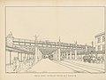
 89 of '(Street Re-alignment and Re-construction of Central London.)' (11182562285).jpg 5,077 × 2,447; 1.62 MB
-
 99 of 'The Thames and its Docks- a lecture. (With plans.)' (11119790694).jpg 3,100 × 2,435; 1 MB
-
 A plan and elevation of a new bridge to be built at Black Fryars. (16761399479).jpg 1,903 × 1,169; 666 KB
-
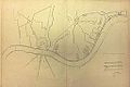
 Archway plan.jpg 800 × 507; 54 KB
-
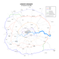
 Bushey Heath Extension - svg.svg 440 × 375; 4 KB
-
 Bushey Heath Extension Mockup.svg 368 × 368; 91 KB
-
 Bushey Heath Extension superimposed on 1934 OS Map.jpg 1,042 × 775; 628 KB
-
 Bushey Heath Extension.png 202 × 179; 8 KB
-
 Crossrail extensions.png 664 × 525; 563 KB
-
 Edgware road kearney tube proposal.jpg 755 × 657; 150 KB
-
 Euston High Speed 2.png 875 × 663; 978 KB
-
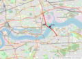
 Gallions Reach Ferry map.png 950 × 638; 298 KB
-
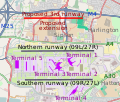 Heathrow Airport map with third runway.svg 512 × 436; 786 KB
-
 Heathrow Southern Railway.png 1,250 × 1,134; 992 KB
-
 HS1-HS2 Camden link.png 1,429 × 782; 414 KB
-

-

-
 John Martin - Design for a London sewer, 1845 (BL Maps 3485.(7.)).jpg 4,370 × 2,897; 5.5 MB
-
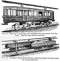 Kearney high-speed railway.jpg 400 × 403; 42 KB
-
 LNWR Underground Loop Line at Euston station, 1907.png 2,460 × 1,089; 1.28 MB
-
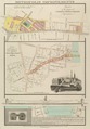
 London and Westminster improved, illustrated by plans Fleuron T138431-12.png 3,027 × 2,408; 406 KB
-
 London Garden Bridge map.svg 512 × 482; 1.61 MB
-
 London Motorway Box 1960s Plan.png 3,366 × 2,319; 433 KB
-
 London Ringway 2 1960s Plan.png 1,699 × 1,220; 201 KB
-
 London Ringways Plan.png 8,858 × 8,858; 1.75 MB
-
 London Ringways Plan.svg 4,486 × 4,189; 223 KB
-
 Lower Thames Crossing option map.jpg 632 × 535; 95 KB
-
 Lower Thames Crossing route, November 2017.svg 574 × 728; 896 KB
-
 LtcApril2017.png 676 × 759; 777 KB
-
 Metropolis Improvements, 1827 - (BL Maps Crace Port 17.35).tif 3,119 × 4,487; 40.06 MB
-
 North west london railway.svg 800 × 288; 8 KB
-
 Northern heights - DRV.png 578 × 326; 70 KB
-
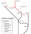
 Northern Heights diagram.png 470 × 550; 17 KB
-
 Northern Heights Northern Line.png 470 × 510; 7 KB
-
 Northern Heights small.png 375 × 216; 7 KB
-
 Northern line extension to Clapham Junction.jpg 741 × 440; 30 KB
-
 Old Towns and New Needs Fig. 2.png 2,110 × 1,404; 1.55 MB
-
 Old Towns and New Needs Fig. 3.png 1,164 × 1,162; 698 KB
-
 Plan for Portland Place and Regent's Circus, 1814.jpg 1,800 × 1,288; 600 KB
-
 Possible charity autonomous.jpg 1,000 × 562; 168 KB
-
 Proposed inner ring road for London shown in 1945.png 624 × 473; 259 KB
-
 ReveleyThamesscheme1796.JPG 700 × 397; 59 KB
-
 RHB Day Bridge Half Open.jpg 6,000 × 4,241; 1.66 MB
-
 Rotherhithe crossing sites.png 437 × 384; 55 KB
-
 Superlink detailed route map large3.svg 1,163 × 703; 11 KB
-
 Thames Gateway bridge location.PNG 892 × 640; 897 KB
-
 Thames Tideway Tunnel proposed route and sites.jpg 1,027 × 802; 62 KB
-
 WestindiaviewofproposalWDaniell1802.jpg 1,050 × 739; 71 KB
-
 West London Orbital Route Map.png 798 × 955; 532 KB
-
 Willesden Junction map with Old Oak Common.png 1,467 × 903; 1.15 MB
.jpg)
_EDWARD_OGLES%27_PLAN.jpg)
_CORPORATION_SCHEME.jpg)
_WYATT%27S_PLAN.jpg)
_SOUTHWARK_SCHEME.jpg)
_RALPH_WALKERS_PLAN_OF_WET_DOCKS_IN_WAPPING.jpg)
_SPENCE%27S_PLAN.jpg)
_REVELEYS_PLAN_(1).jpg)
_REVELEY%27S_PLAN_(2).jpg)
_REVELEY%27S_PLAN_(3).jpg)
_REVELEY%27S_PLAN_(4).jpg)
_no._1-26%27_(11169575363).jpg)
%27_(11182562285).jpg)
%27_(11119790694).jpg)
.jpg)


.jpg)
.jpg)
).jpg)


_THE_RIVER_THAMES_SHEWING_ALL_DOCKS_OF_LONDON_WITH_THE_EXTENSIONS_IN_PROGRESS.jpg)