Category:Private streets in London
Jump to navigation
Jump to search
Subcategories
This category has the following 12 subcategories, out of 12 total.
B
- Bacon's Lane (4 F)
E
G
- Gatcombe Way, Cockfosters (7 F)
K
L
- Lennox Gardens Mews (2 F)
- Lygon Place (8 F)
M
- Mountfort Crescent (2 F)
P
- Pont Street Mews (1 F)
- Portobello Mews (1 F)
T
- The Lindens, North Finchley (5 F)
Y
- York Terrace West (6 F)
Media in category "Private streets in London"
The following 36 files are in this category, out of 36 total.
-
 Aberdeen Park conservation area - geograph.org.uk - 1466795.jpg 640 × 475; 89 KB
-

-
 Alexandra Estate underground garages and private road.jpg 4,048 × 3,036; 4.68 MB
-
 Arkley Drive - geograph.org.uk - 384553.jpg 640 × 480; 78 KB
-
 Art Street - geograph.org.uk - 838757.jpg 480 × 640; 61 KB
-
 Bolingbroke Close, Cockfosters.JPG 4,000 × 3,000; 3.87 MB
-
 Candle Street, E1 - geograph.org.uk - 2281894.jpg 640 × 480; 72 KB
-
 Carlton Mews - geograph.org.uk - 1260191.jpg 640 × 480; 64 KB
-
 Courtenay Avenue - geograph.org.uk - 401262.jpg 480 × 640; 187 KB
-
 Cropthorne Court - geograph.org.uk - 905942.jpg 640 × 415; 169 KB
-

-
 Fitzroy Park, Highgate - geograph.org.uk - 1324661.jpg 640 × 480; 92 KB
-
 Forest Ridge, Keston Park, BR2 - geograph.org.uk - 75427.jpg 640 × 466; 128 KB
-
 Galva Road, East Barnet - geograph.org.uk - 1091941.jpg 640 × 428; 79 KB
-
 Gated Entrance to Mallard Close - geograph.org.uk - 744800.jpg 640 × 480; 60 KB
-
 Glanleam Road, Stanmore - geograph.org.uk - 2244678.jpg 1,600 × 1,200; 554 KB
-
 Golf Side private road, Cheam - geograph.org.uk - 55233.jpg 640 × 480; 90 KB
-
 Government Row, Enfield - geograph.org.uk - 1328370.jpg 640 × 480; 104 KB
-
 Hillway, N6 - geograph.org.uk - 371130.jpg 640 × 480; 134 KB
-
-
 Langton Way, Blackheath - geograph.org.uk - 634819.jpg 640 × 480; 141 KB
-
 London - April 2009 (3496593171).jpg 2,816 × 2,112; 3.28 MB
-
 Ludgrove Hall 8 August 2015 02.JPG 4,000 × 3,000; 4.08 MB
-
 Mallard Close - geograph.org.uk - 744791.jpg 640 × 480; 80 KB
-
 Manor Way, SE3 - geograph.org.uk - 377978.jpg 640 × 480; 158 KB
-
 Marrick Close, Barnes - geograph.org.uk - 1309050.jpg 427 × 640; 117 KB
-
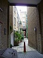
 Private passage from Tonbridge Street to Whidborne Street 01.JPG 3,000 × 4,000; 4.12 MB
-
 Private passage from Tonbridge Street to Whidborne Street 02.JPG 3,000 × 4,000; 4.12 MB
-
 Ruskin Close, Hampstead Garden Suburb.jpg 3,264 × 2,448; 4.49 MB
-
 St Cecilia Place, Humber Road, Greenwich - geograph.org.uk - 1163654.jpg 640 × 480; 130 KB
-
 St. Columba's Drive - geograph.org.uk - 1005686.jpg 427 × 640; 167 KB
-
 Street Sign 'Balvaird Place' - geograph.org.uk - 1203260.jpg 640 × 480; 104 KB
-
 Street Sign, E9. In the London Borough of Hackney, but ..Apr 2009.jpg 1,152 × 864; 194 KB
-
 Sundial Court, Chiswell Street, EC1 - geograph.org.uk - 1099037.jpg 640 × 480; 107 KB
-
 The Hollies street sign 2024-04-15.jpg 4,032 × 3,024; 3.48 MB
-
 Welcomes Road, Kenley - geograph.org.uk - 2663044.jpg 640 × 436; 74 KB


.jpg)


