Category:Preston-under-Scar
Jump to navigation
Jump to search
village in United Kingdom  | |||||
| Upload media | |||||
| Instance of | |||||
|---|---|---|---|---|---|
| Location | Richmondshire, North Yorkshire, Yorkshire and the Humber, England | ||||
 | |||||
Subcategories
This category has the following 2 subcategories, out of 2 total.
B
Media in category "Preston-under-Scar"
The following 180 files are in this category, out of 180 total.
-
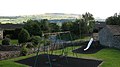 A 'swinging' view - geograph.org.uk - 525234.jpg 640 × 359; 69 KB
-
 A circular walk from Leyburn via Wensley village (32) (geograph 7326860).jpg 4,176 × 3,132; 3.62 MB
-
 A circular walk from Leyburn via Wensley village (37) (geograph 7327928).jpg 4,185 × 3,139; 3.28 MB
-
 Access to The Estate Office at Bolton Hall - geograph.org.uk - 4851745.jpg 1,600 × 1,067; 754 KB
-
 Across Scarlet Wood - geograph.org.uk - 5052458.jpg 4,320 × 3,240; 2.98 MB
-
 Across Wensley Quarry - geograph.org.uk - 5052447.jpg 4,317 × 2,901; 3.31 MB
-
 Approaching Condenser Wood - geograph.org.uk - 4854246.jpg 1,600 × 1,067; 765 KB
-

-
 Barn on south side of Light Lane - geograph.org.uk - 3739453.jpg 1,024 × 683; 247 KB
-
 Bella Gill Beck - geograph.org.uk - 5242459.jpg 3,240 × 4,320; 4.12 MB
-
 Benchmark on barn beside Light Lane - geograph.org.uk - 3739450.jpg 683 × 1,024; 213 KB
-
 Benchmark on farm buildings, Preston Pasture - geograph.org.uk - 3738864.jpg 683 × 1,024; 331 KB
-

-

-
 Benchmark on large roadside stone - geograph.org.uk - 3539081.jpg 1,024 × 683; 298 KB
-

-
 Benchmark on small barn SW of Preston-under-Scar - geograph.org.uk - 3739477.jpg 683 × 1,024; 291 KB
-
 Benchmark on Stoneham House - geograph.org.uk - 3539154.jpg 683 × 1,024; 363 KB
-
 Black Beck - geograph.org.uk - 2860187.jpg 1,024 × 768; 133 KB
-
 Black Beck - geograph.org.uk - 5861114.jpg 3,238 × 4,318; 3.36 MB
-
 Black Beck Bridge - geograph.org.uk - 2860184.jpg 1,024 × 768; 153 KB
-
 Bolton Hall - a side view - geograph.org.uk - 5242682.jpg 4,320 × 3,240; 3.94 MB
-
 Bolton Hall - geograph.org.uk - 4413681.jpg 640 × 480; 168 KB
-
 Bolton Hall - geograph.org.uk - 4413683.jpg 640 × 480; 153 KB
-
 Bolton Hall - geograph.org.uk - 4851736.jpg 1,600 × 1,067; 506 KB
-
 Bolton Hall from Lord's Bridge - geograph.org.uk - 6009193.jpg 1,600 × 900; 591 KB
-
 Boundary stone at Robin Cross - geograph.org.uk - 5997770.jpg 3,239 × 4,319; 5.02 MB
-
-
 Broomber Rigg - geograph.org.uk - 5572428.jpg 5,184 × 3,456; 6.67 MB
-
 Candle House Rigg - geograph.org.uk - 3490375.jpg 1,600 × 1,200; 558 KB
-
 Chimney at Keld Heads Smelt Mill - geograph.org.uk - 4854729.jpg 1,600 × 1,067; 760 KB
-
 Condenser remains, Keld Heads lead mine - geograph.org.uk - 5242456.jpg 4,320 × 3,240; 4.89 MB
-
 Converted Peat Store at Tullis Cote - geograph.org.uk - 4854704.jpg 1,600 × 1,067; 717 KB
-
 Cottages at Preston-under-Scar - geograph.org.uk - 75583.jpg 640 × 427; 163 KB
-
 Cranehow Bottom - geograph.org.uk - 4130083.jpg 2,204 × 2,160; 681 KB
-
 Cranehow Bottom - geograph.org.uk - 5570600.jpg 5,184 × 3,456; 7.5 MB
-
 Cranehowe Bottom - geograph.org.uk - 3490541.jpg 1,600 × 1,200; 706 KB
-
 Dark moorland on a December day - geograph.org.uk - 5997767.jpg 4,319 × 2,617; 2.31 MB
-
 Disused Quarry - geograph.org.uk - 4413732.jpg 640 × 480; 146 KB
-
 Disused tip NE of Preston-under-Scar - geograph.org.uk - 3738820.jpg 1,024 × 683; 280 KB
-
 Do soldiers train to shoot grouse^ - geograph.org.uk - 2860213.jpg 1,024 × 768; 199 KB
-

-
 Ewe with lambs - geograph.org.uk - 808670.jpg 640 × 480; 133 KB
-
 Far Cranehow Bottom - geograph.org.uk - 2860535.jpg 1,024 × 768; 136 KB
-

-
 Farm Outbuilding behind Bolton Hall - geograph.org.uk - 4851751.jpg 1,600 × 1,067; 549 KB
-
 Farm Track heading towards Preston Spring - geograph.org.uk - 4854225.jpg 1,600 × 1,067; 652 KB
-
 Farmland in Wensleydale - geograph.org.uk - 5950480.jpg 640 × 415; 95 KB
-
 Fence at Snowden Man - geograph.org.uk - 4251007.jpg 640 × 480; 101 KB
-
 Field Barn at Preston Under Scar - geograph.org.uk - 6355038.jpg 800 × 533; 157 KB
-
 Field Barn, Wood End - geograph.org.uk - 6355070.jpg 800 × 533; 127 KB
-
 Fields towards West Wood - geograph.org.uk - 1411699.jpg 640 × 357; 37 KB
-
 Firing range from Whipperdale Bank - geograph.org.uk - 2546293.jpg 1,024 × 397; 99 KB
-
 Footpath over the Line - geograph.org.uk - 2536884.jpg 800 × 531; 98 KB
-
 Footpath through West Wood - geograph.org.uk - 1812647.jpg 2,048 × 1,536; 2.24 MB
-
 Former Wensley Railway Station - geograph.org.uk - 5533567.jpg 640 × 427; 75 KB
-
 Former Wensley Station - geograph.org.uk - 2536882.jpg 800 × 531; 124 KB
-
 Fox Gill - geograph.org.uk - 4130079.jpg 3,920 × 2,204; 1.58 MB
-
 Fungi, Preston-under-scar - geograph.org.uk - 2134832.jpg 640 × 480; 73 KB
-
 Fungi, Preston-under-scar - geograph.org.uk - 2134852.jpg 640 × 481; 98 KB
-
 Fungi, Preston-under-scar - geograph.org.uk - 2134878.jpg 480 × 640; 176 KB
-
 Fungi, Preston-under-scar - geograph.org.uk - 2134891.jpg 480 × 640; 102 KB
-
 Gate, Manhole ^ a couple of warning signs - geograph.org.uk - 4677222.jpg 4,000 × 3,000; 3.4 MB
-
 Gateway for Preston Pasture fields - geograph.org.uk - 3739060.jpg 1,024 × 683; 193 KB
-
 Gateway to pastures under Lang Scar - geograph.org.uk - 3739041.jpg 1,024 × 683; 211 KB
-
 Grazing near Moor House Farm - geograph.org.uk - 5533580.jpg 640 × 426; 61 KB
-
 Grazing near Spring Barn - geograph.org.uk - 5533568.jpg 640 × 427; 61 KB
-
 Hellgill Bridge - geograph.org.uk - 4413735.jpg 640 × 360; 125 KB
-
 Hellgill Bridge - geograph.org.uk - 5242687.jpg 4,320 × 3,240; 4.37 MB
-
 Herontree Allotment - geograph.org.uk - 5572432.jpg 5,184 × 3,456; 6.13 MB
-
 Isolated property near Preston-under-Scar - geograph.org.uk - 5855268.jpg 1,024 × 768; 124 KB
-
 Junction of tracks at entrance to Bolton Hall - geograph.org.uk - 2598437.jpg 1,024 × 683; 191 KB
-
 Keld Heads Lead Mine Remains - geograph.org.uk - 4413727.jpg 640 × 480; 187 KB
-
 Keldheads - peat store - geograph.org.uk - 1586501.jpg 640 × 426; 122 KB
-
 Keldheads Gill - geograph.org.uk - 6161482.jpg 2,048 × 1,536; 1.86 MB
-
 Keldheads Lead Mine - geograph.org.uk - 1584765.jpg 421 × 640; 240 KB
-
 Laithe near the railway, Preston-under-Scar - geograph.org.uk - 5855263.jpg 1,024 × 768; 131 KB
-
 Lane leading East out of Preston-under-Scar - geograph.org.uk - 4854239.jpg 1,600 × 1,067; 707 KB
-
 Lead flues, Keldheads - geograph.org.uk - 1586504.jpg 640 × 426; 158 KB
-
 Light Lane to Preston Under Scar - geograph.org.uk - 1411711.jpg 640 × 480; 67 KB
-
 Line of old conveyor, Preston Quarry - geograph.org.uk - 808660.jpg 480 × 640; 87 KB
-
 Looking SSE from Preston Moor - geograph.org.uk - 888055.jpg 640 × 448; 66 KB
-
 Looking west from Leyburn Shawl - geograph.org.uk - 6372130.jpg 1,600 × 1,200; 268 KB
-
 Memorial to Fourth Baron Ashcombe - geograph.org.uk - 5570585.jpg 5,184 × 3,456; 6.1 MB
-
 Mining Spoilheaps and Debris on the Edge of Preston Moor - geograph.org.uk - 5570827.jpg 5,184 × 3,456; 5.77 MB
-
 Moorland Track below Smithy Hill - geograph.org.uk - 5572410.jpg 5,184 × 3,456; 7.36 MB
-
 Moorland, part of Redmire Moor or close to it - geograph.org.uk - 5668822.jpg 1,499 × 902; 1.14 MB
-
 Near Preston - geograph.org.uk - 6161466.jpg 2,048 × 1,536; 994 KB
-
 Old Coal Pit in Bailey Pasture - geograph.org.uk - 4130076.jpg 3,920 × 2,204; 2.28 MB
-
 Old flue line above Preston - geograph.org.uk - 808635.jpg 640 × 480; 47 KB
-
 Old pits on Redmire Moor - geograph.org.uk - 808612.jpg 640 × 349; 52 KB
-
 On Preston Moor - geograph.org.uk - 5570606.jpg 5,184 × 3,456; 6.25 MB
-
 On the Moorland Road between Grinton and Wensleydale - geograph.org.uk - 5571811.jpg 5,157 × 3,300; 7.68 MB
-
 On Wimp Hill - geograph.org.uk - 5572429.jpg 5,184 × 3,456; 5.61 MB
-
 Open access moorland - geograph.org.uk - 2860216.jpg 1,024 × 768; 141 KB
-
 Passing minor road junction to Preston under Scar - geograph.org.uk - 5795667.jpg 3,074 × 2,304; 2.2 MB
-
 Paths Split in West Wood - geograph.org.uk - 4851767.jpg 1,600 × 1,067; 727 KB
-
 Pedalling uphill - geograph.org.uk - 5997765.jpg 3,270 × 1,889; 989 KB
-
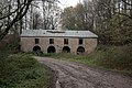
 Preston Mill - geograph.org.uk - 448358.jpg 480 × 640; 101 KB
-
 Preston Mill, Preston-under-Scar - geograph.org.uk - 5855259.jpg 1,024 × 768; 175 KB
-
 Preston Quarry - geograph.org.uk - 808649.jpg 640 × 480; 106 KB
-
 Preston Scar view - geograph.org.uk - 5052424.jpg 4,320 × 3,240; 3.47 MB
-
 Preston under Scar - geograph.org.uk - 883024.jpg 640 × 329; 42 KB
-

-
 Preston-under-Scar MMB 01.jpg 4,043 × 1,965; 1.73 MB
-
 Preston-under-Scar.jpg 640 × 359; 61 KB
-
 Public Footpath, West Wood - geograph.org.uk - 4412565.jpg 640 × 480; 162 KB
-
 Pumping Engine, Keld Heads Mine - geograph.org.uk - 2658706.jpg 1,500 × 2,000; 1.64 MB
-
 Putting out a manure fire (1) - geograph.org.uk - 5855275.jpg 1,024 × 768; 140 KB
-
 Putting out a manure fire (2) - geograph.org.uk - 5855273.jpg 1,024 × 768; 186 KB
-
 Quarry at Preston Scar - geograph.org.uk - 6124014.jpg 1,600 × 1,060; 256 KB
-
 Quarry workings - Wensley Quarry - geograph.org.uk - 5052490.jpg 4,320 × 2,874; 2.56 MB
-
 Ragwort on Preston Scar - geograph.org.uk - 5052454.jpg 4,320 × 2,969; 2.63 MB
-
 Redmire level crossing - geograph.org.uk - 886002.jpg 640 × 480; 106 KB
-
 Redmire Quarry - geograph.org.uk - 1060874.jpg 640 × 422; 74 KB
-
 Ringing Hole - geograph.org.uk - 4635800.jpg 4,000 × 3,000; 3.79 MB
-
 Road into Preston-under-Scar from the Northeast - geograph.org.uk - 3738799.jpg 1,024 × 683; 277 KB
-
 Road near Preston - geograph.org.uk - 6161471.jpg 2,048 × 1,536; 1.49 MB
-
 Road northeast of Preston-under-Scar. - geograph.org.uk - 3738851.jpg 1,024 × 683; 311 KB
-
 Road over Rail - geograph.org.uk - 2536911.jpg 800 × 531; 154 KB
-
 Robin Cross - geograph.org.uk - 5571793.jpg 5,184 × 3,456; 7.63 MB
-
 Rock outcrop in Thowker Wood - geograph.org.uk - 5855254.jpg 1,024 × 768; 411 KB
-
 Ruined Barn at Staingill Folds - geograph.org.uk - 4130073.jpg 3,838 × 1,253; 238 KB
-

-

-

-
 Ruined Flue - geograph.org.uk - 4412588.jpg 640 × 480; 135 KB
-
 Ruins of Keld Heads Pumping House - geograph.org.uk - 4854733.jpg 1,600 × 1,067; 768 KB
-
 Running the Gauntlet - geograph.org.uk - 5572403.jpg 5,184 × 3,456; 6.46 MB
-
 Scarth Nick view - geograph.org.uk - 5052423.jpg 4,320 × 3,240; 4.21 MB
-
 Seat with a view of Wensleydale - geograph.org.uk - 4412580.jpg 640 × 360; 105 KB
-
 Sewage works, Preston-under-Scar - geograph.org.uk - 5855256.jpg 1,024 × 768; 326 KB
-
 Sheep fields between the railway and the road - geograph.org.uk - 1840172.jpg 1,024 × 768; 114 KB
-
 Shooter's Hut ^ Mining Remains in Cranehow Bottom - geograph.org.uk - 4130067.jpg 2,204 × 3,920; 1.82 MB
-
 Small Reservoir attached to the Cobscar Mill - geograph.org.uk - 5570575.jpg 5,184 × 3,456; 5.78 MB
-
 Snowden Man - geograph.org.uk - 5571392.jpg 5,184 × 3,456; 7.61 MB
-
 Spring Barn - geograph.org.uk - 5533572.jpg 640 × 383; 56 KB
-
 Spring lamb - geograph.org.uk - 808664.jpg 640 × 480; 70 KB
-
 Squeeze Stile into Moorland - geograph.org.uk - 4677229.jpg 4,000 × 3,000; 3.77 MB
-
 St. Margaret's Church, Preston-under-Scar - geograph.org.uk - 4854232.jpg 1,600 × 1,067; 525 KB
-
 Stone Culvert, Keldheads Smelt Mill - geograph.org.uk - 4413721.jpg 640 × 480; 173 KB
-
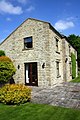 Stoneham House - geograph.org.uk - 3539165.jpg 683 × 1,024; 251 KB
-
 Street scene, Preston-under-Scar - geograph.org.uk - 2134736.jpg 640 × 482; 71 KB
-
 Strip of Woodland on the Southern Edge of Preston Moor - geograph.org.uk - 5570663.jpg 5,184 × 3,456; 6.42 MB
-
 Survivor of the lead mining industry - geograph.org.uk - 5242447.jpg 3,240 × 4,320; 4.63 MB
-
 The edge of the escarpment at Scarth Nick - geograph.org.uk - 4835302.jpg 1,600 × 1,067; 526 KB
-
 The line to Leyburn - geograph.org.uk - 886008.jpg 640 × 480; 113 KB
-
 The road to Redmire - geograph.org.uk - 5052420.jpg 3,240 × 4,320; 3.56 MB
-
 The Wensleydale Railway - geograph.org.uk - 283469.jpg 640 × 480; 97 KB
-
 Thowker Wood - geograph.org.uk - 4413747.jpg 640 × 480; 182 KB
-
 Towards The End Of The Line - geograph.org.uk - 283479.jpg 640 × 480; 97 KB
-
 Track across the moor - geograph.org.uk - 5997762.jpg 4,297 × 2,532; 2.32 MB
-
 Track heading West out of Preston-under-Scar - geograph.org.uk - 4853836.jpg 1,600 × 1,067; 611 KB
-
 Track leading onto Preston and Redmire Moors - geograph.org.uk - 5570659.jpg 5,184 × 3,456; 6.01 MB
-
 Track leading towards Cobscar Mill - geograph.org.uk - 5570673.jpg 5,184 × 3,456; 5.79 MB
-
 Track on Redmire Moor - geograph.org.uk - 5570878.jpg 5,184 × 3,456; 6.72 MB
-
 Tree by the road, Preston-under-Scar - geograph.org.uk - 2134767.jpg 640 × 480; 59 KB
-
 Tullis Cote Farm - geograph.org.uk - 2658705.jpg 2,000 × 1,500; 1.81 MB
-
 Tullis Cote Farmhouse - geograph.org.uk - 4854711.jpg 1,600 × 1,067; 677 KB
-
-
 View from the Wensleydale Railway - geograph.org.uk - 2536916.jpg 800 × 531; 118 KB
-
 View from the Wensleydale Railway - geograph.org.uk - 2536923.jpg 800 × 531; 81 KB
-
 View from the Wensleydale Railway - geograph.org.uk - 2536926.jpg 800 × 531; 87 KB
-
 View into Wensleydale from Scarth Nick - geograph.org.uk - 4835313.jpg 1,600 × 1,067; 566 KB
-

-

-
 Warning Sign on Ellerton Moor - geograph.org.uk - 5571802.jpg 5,184 × 3,456; 7.33 MB
-
 Waterfall, Gillfield Wood - geograph.org.uk - 2657122.jpg 2,000 × 1,500; 2.33 MB
-
 Wensley Quarry - geograph.org.uk - 4412577.jpg 640 × 480; 113 KB
-
 Wensley Quarry - geograph.org.uk - 5052434.jpg 4,320 × 2,710; 2.77 MB
-
 Wensleydale Farmland - geograph.org.uk - 5950477.jpg 640 × 416; 113 KB
-
 Wensleydale Railway looking east - geograph.org.uk - 5242463.jpg 3,129 × 4,171; 2.7 MB
-
 Wensleydale Railway looking west - geograph.org.uk - 5242462.jpg 3,167 × 4,223; 2.86 MB
-
 Wensleydale Railway near Keld Heads - geograph.org.uk - 4854743.jpg 1,600 × 999; 799 KB
-
 Wensleydale Railway, nr. Preston under Scar - geograph.org.uk - 2658836.jpg 2,000 × 1,500; 1.77 MB
-
 What lurks beneath^ - geograph.org.uk - 5052506.jpg 4,320 × 3,240; 2.04 MB
-
 Wooden Enclosure on Ellerton Moor - geograph.org.uk - 5571808.jpg 5,184 × 3,456; 5.82 MB
-
 Fallen Boundary Stone - geograph.org.uk - 309569.jpg 640 × 480; 169 KB
-
 Farm Buildings at Preston Under Scar. - geograph.org.uk - 448347.jpg 640 × 480; 77 KB
-
 Stream in Gillfield Wood - geograph.org.uk - 448342.jpg 480 × 640; 162 KB

_(geograph_7326860).jpg)
_(geograph_7327928).jpg)


_-_geograph.org.uk_-_5855275.jpg)
_-_geograph.org.uk_-_5855273.jpg)


