Category:Prenton Hall
Jump to navigation
Jump to search
| Object location | | View all coordinates using: OpenStreetMap |
|---|
architectural structure in Wirral, Merseyside, UK .jpg) | |||||
| Upload media | |||||
| Instance of | |||||
|---|---|---|---|---|---|
| Location | Wirral, Merseyside, North West England, England | ||||
| Heritage designation |
| ||||
 | |||||
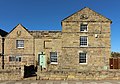
Prenton Hall is a former farmhouse dating to ther 17th century and since split into two dwellings, each Grade II listed separately.
Media in category "Prenton Hall"
The following 3 files are in this category, out of 3 total.
-
 Prenton Hall (East).jpg 4,115 × 2,865; 8.96 MB
-
 Prenton Hall (West).jpg 4,167 × 3,081; 9.22 MB
-
 Prenton Hall.jpg 4,113 × 3,318; 8.65 MB
.jpg)
