Category:Predicted cultivation plant maps of the United States
Jump to navigation
Jump to search
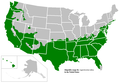
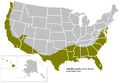
English: Potential cultivated ranges predicted for garden plants in the United States, based on cold tolerance. Note that other climate factors, such as rainfall patterns and summer heat, are not factored, so the maps are very ineffective as predictors of actual cultivation potential, and therefore of very limited value.
Media in category "Predicted cultivation plant maps of the United States"
The following 10 files are in this category, out of 10 total.
-
 Crapemyrtlemap.PNG 841 × 580; 31 KB
-
 Crapemyrtlemap2.PNG 841 × 580; 31 KB
-
 Liveoakmap.PNG 841 × 580; 29 KB
-
 Magnoliamap.PNG 841 × 580; 29 KB
-
 Needlepalmmap.PNG 841 × 580; 30 KB
-
 Possible potential cultivation area for Castanea mollissima in USA.png 6,364 × 3,793; 634 KB
-
 Sabalminormap.PNG 841 × 580; 30 KB
-
 Sabalminormap2.PNG 841 × 580; 30 KB
-
 SabalPalmettoMap.jpg 701 × 565; 49 KB
-
 Silktreemap.PNG 841 × 580; 30 KB


