Category:Prat del Comte - Fontcalda
Jump to navigation
Jump to search
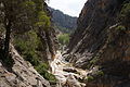
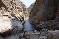
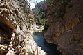
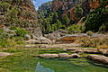
Català: Geozona formada per la serra del Crestall, les Crestes de Voladins i l'Agulla, el coll de la Fontcalda i la
muntanya de la Tossa. L'indret està drenat pel riu de la Canaleta i la Vall del Frare.
|
This is a category with photos about a geologic site or geotope in Catalonia, Spain, with id: IEIGC-315
|
| Object location | | View all coordinates using: OpenStreetMap |
|---|
| NO WIKIDATA ID FOUND! Search for Prat del Comte - Fontcalda on Wikidata | |
| Upload media |
Subcategories
This category has only the following subcategory.
S
Media in category "Prat del Comte - Fontcalda"
The following 14 files are in this category, out of 14 total.
-
 Els Estrets del Riu Canaletes DSC00529.JPG 3,264 × 4,912; 5.94 MB
-
 Els Estrets del Riu Canaletes DSC00530.JPG 4,912 × 3,264; 7.06 MB
-
 Els Estrets del Riu Canaletes DSC00531.JPG 4,912 × 3,264; 6.28 MB
-
 Els Estrets del Riu Canaletes DSC00535.JPG 3,264 × 4,912; 4.84 MB
-
 Els Estrets del Riu Canaletes DSC00536.JPG 4,912 × 3,264; 6.66 MB
-
 Els Estrets del Riu Canaletes DSC00540.JPG 4,912 × 3,264; 7.66 MB
-
 Els Estrets del Riu Canaletes DSC00543.JPG 3,264 × 4,912; 6.28 MB
-
 Els Estrets del Riu Canaletes DSC00546.JPG 4,912 × 3,264; 7.28 MB
-
 Els Estrets del Riu Canaletes DSC00550.JPG 4,912 × 3,264; 7.5 MB
-
 Els Estrets del Riu Canaletes DSC00551.JPG 4,912 × 3,264; 7.75 MB
-
 Els Estrets del Riu Canaletes DSC00553.JPG 4,912 × 3,264; 6.53 MB
-
 La Fontcalda DSC00539.JPG 4,912 × 3,264; 7.66 MB
-
 Riu Canatetes.JPG 850 × 1,134; 326 KB
-
 Santuari de Fontcalda (Gandesa) - 6.jpg 3,056 × 4,592; 3.92 MB


_-_6.jpg)