Category:Portreath
Jump to navigation
Jump to search
village and civil parish in Cornwall, England, UK  | |||||
| Upload media | |||||
| Instance of |
| ||||
|---|---|---|---|---|---|
| Location | Cornwall, South West England, England | ||||
 | |||||
Subcategories
This category has the following 13 subcategories, out of 13 total.
B
- Bridge, Cornwall (14 F)
C
G
- Gull Rock, Portreath (18 F)
H
- Huer's Hut, Portreath (10 F)
N
- North Cliff, Cornwall (32 F)
P
- Porth-cadjack Cove (6 F)
- Portreath Branch Line (18 F)
- Portreath light (7 F)
R
- RAF Portreath (15 F)
S
- Sally's Bottom, Cornwall (20 F)
Media in category "Portreath"
The following 172 files are in this category, out of 172 total.
-
 23 Portreath.JPG 4,288 × 3,216; 3.39 MB
-

-
 A field above Cambridge Farm - geograph.org.uk - 3190016.jpg 1,142 × 857; 344 KB
-
 A field of greens near Porthtowan - geograph.org.uk - 3203594.jpg 1,142 × 857; 344 KB
-

-
 Bad Storm - geograph.org.uk - 2441303.jpg 600 × 450; 21 KB
-
 Basset Cove - geograph.org.uk - 23320.jpg 640 × 479; 112 KB
-
 Blocked off harbour entrance, Portreath - geograph.org.uk - 4792319.jpg 2,000 × 1,333; 1.25 MB
-
 Boiling Sea under North Cliffs - geograph.org.uk - 189506.jpg 640 × 427; 99 KB
-
 Building overlooking Portreath Beach (6415).jpg 4,288 × 2,848; 6.31 MB
-
 Bus shelter in the centre of Portreath - geograph.org.uk - 3824267.jpg 1,536 × 1,154; 919 KB
-
 Bus Stop ^ Shelter, Portreath - geograph.org.uk - 3019751.jpg 640 × 464; 67 KB
-
 Cambridge Farm barns - geograph.org.uk - 3190021.jpg 1,142 × 857; 327 KB
-
 Capped shaft, west of Porthtowan - geograph.org.uk - 2807536.jpg 2,592 × 1,944; 1.72 MB
-
 Carvannel Downs - geograph.org.uk - 6268020.jpg 1,024 × 768; 747 KB
-

-
-
 Chimney on the coast near Porthtowan - geograph.org.uk - 2005828.jpg 3,072 × 2,304; 2.26 MB
-
 Chimney on the coast near Porthtowan - geograph.org.uk - 2006030.jpg 2,304 × 3,072; 1.73 MB
-
 Cliff top flowers on Gooden Heane Point - geograph.org.uk - 1886330.jpg 640 × 480; 137 KB
-
 Cliffs and beach at Tobban Horse - geograph.org.uk - 3205028.jpg 814 × 1,088; 259 KB
-
 Cliffs at Western Cove (6431).jpg 4,288 × 2,848; 6.2 MB
-
 Cliffs near Portreath (6413).jpg 4,288 × 2,848; 6.81 MB
-
 Cliffs north of Portreath - geograph.org.uk - 3203904.jpg 1,142 × 857; 333 KB
-
 Cliffs on the east side of the cove - geograph.org.uk - 3204825.jpg 748 × 998; 325 KB
-
 Cloud north of Portreath (6410).jpg 4,288 × 2,848; 4.61 MB
-
 Coast path beside Portreath Airfield - geograph.org.uk - 2006019.jpg 3,072 × 2,304; 2.89 MB
-
 Coast Path north of Portreath - geograph.org.uk - 3203908.jpg 1,142 × 857; 319 KB
-
 Coast path north-east of Portreath - geograph.org.uk - 2777534.jpg 640 × 427; 173 KB
-
 Coast scene - geograph.org.uk - 6286955.jpg 800 × 600; 122 KB
-
 Coastal path entering MOD property - geograph.org.uk - 2777568.jpg 640 × 427; 184 KB
-
 Coastal path near Portreath airfield - geograph.org.uk - 2777604.jpg 640 × 427; 180 KB
-
 Coastal path towards Portreath - geograph.org.uk - 2777601.jpg 640 × 429; 256 KB
-
 Coastguard look-out tower, Portreath - geograph.org.uk - 6224365.jpg 3,456 × 5,184; 7.16 MB
-
 Concrete bunkers and shelters - geograph.org.uk - 3204838.jpg 1,044 × 783; 316 KB
-
 Country lane T-junction south of Porthtowan - geograph.org.uk - 3203871.jpg 1,142 × 857; 392 KB
-
 Crane Islands - geograph.org.uk - 189776.jpg 640 × 427; 78 KB
-

-
 Dawn at Portreath - geograph.org.uk - 4792233.jpg 2,000 × 1,155; 1.14 MB
-
 Diamond - geograph.org.uk - 2777595.jpg 640 × 427; 156 KB
-
 Diamond Rock - geograph.org.uk - 23503.jpg 640 × 479; 106 KB
-
 Downstream on the brook in Bridge - geograph.org.uk - 3190058.jpg 734 × 979; 418 KB
-
 Dry heath - geograph.org.uk - 6286951.jpg 800 × 600; 148 KB
-
 Entrance to the Porthtowan Tourist Park - geograph.org.uk - 3204556.jpg 979 × 734; 283 KB
-
 Evening over Portreath, 1995 - geograph.org.uk - 5003664.jpg 2,398 × 1,418; 2.74 MB
-
 Feadon Farm pond - geograph.org.uk - 3218206.jpg 979 × 734; 434 KB
-
 Feeding The Hungry Chicken.jpg 3,968 × 2,232; 1.36 MB
-
 Field at Cambrose - geograph.org.uk - 1864812.jpg 640 × 480; 96 KB
-
 Fields south of Factory Farm - geograph.org.uk - 3203571.jpg 1,142 × 857; 401 KB
-
 Flowers in Portreath (6422).jpg 4,288 × 2,848; 5.17 MB
-
 Godrevy Island from Portreath (6433).jpg 4,288 × 2,848; 4.41 MB
-
 Gooden Heane Cove (6414).jpg 4,288 × 2,848; 6.27 MB
-
 Gooden Heane Cove - geograph.org.uk - 1838927.jpg 640 × 480; 88 KB
-
 Gooden Heane Cove - geograph.org.uk - 2507901.jpg 1,024 × 768; 208 KB
-
 Gooden Heane Cove - geograph.org.uk - 2777310.jpg 640 × 424; 203 KB
-
 Gooden Heane Cove and Point - geograph.org.uk - 1838935.jpg 480 × 640; 96 KB
-
 Gooden Heane Point - geograph.org.uk - 1838918.jpg 640 × 480; 116 KB
-
 Gooden Heane Point - geograph.org.uk - 1886353.jpg 480 × 640; 104 KB
-
 Headland below Nancekuke Common - geograph.org.uk - 2005848.jpg 3,072 × 2,304; 1.98 MB
-
 Heathery slope - geograph.org.uk - 6286966.jpg 800 × 600; 144 KB
-
 Helicopter off Portreath (6428).jpg 4,288 × 2,848; 3.87 MB
-
 Hells Mouth Cafe - geograph.org.uk - 318431.jpg 640 × 427; 114 KB
-
 Illogan Woods - geograph.org.uk - 5671492.jpg 5,205 × 2,927; 5.06 MB
-
 Illogan Woods - geograph.org.uk - 5671497.jpg 5,343 × 3,005; 4.23 MB
-
 Inclined plane in Portreath (6420).jpg 4,288 × 2,848; 6.27 MB
-
 Jubilee memorial in Portreath (6421).jpg 4,288 × 2,848; 6.56 MB
-
 Junction With B3300 Near Cambrose - geograph.org.uk - 5835738.jpg 640 × 480; 61 KB
-
 Kites shaft - geograph.org.uk - 2005832.jpg 3,072 × 2,304; 2.21 MB
-
 Landmark - geograph.org.uk - 5798391.jpg 476 × 640; 384 KB
-
 Lighthouse Hill road, Portreath - geograph.org.uk - 3387903.jpg 2,816 × 2,112; 1.77 MB
-
 Lighthouse or Monkey Hut, Portreath Pier - geograph.org.uk - 6224359.jpg 5,184 × 3,456; 6.54 MB
-
 Looking down into Gooden Heane Cove - geograph.org.uk - 1886395.jpg 480 × 640; 147 KB
-
 Looking Down on Portreath.jpg 1,280 × 824; 809 KB
-
 Mining relics at Wheal Towan - geograph.org.uk - 6277709.jpg 1,024 × 768; 492 KB
-
 Modern housing - geograph.org.uk - 6286943.jpg 800 × 600; 106 KB
-
 Moos Nov 2009 765.jpg 3,504 × 2,336; 2.95 MB
-
 Old bridge on track to Forge Manor Farm - geograph.org.uk - 4874448.jpg 1,600 × 1,200; 451 KB
-

-

-
 Old Portreath Road - geograph.org.uk - 98744.jpg 640 × 480; 82 KB
-

-
 Ordnance Survey Flush Bracket S6920 - geograph.org.uk - 5432228.jpg 4,000 × 3,000; 1.67 MB
-
 Penberthy Road in Portreath - geograph.org.uk - 5384780.jpg 4,000 × 3,000; 3.16 MB
-
 Pool in quarry at Sally's Bottom (6397).jpg 4,288 × 2,848; 6.29 MB
-
 Portreath , Green Lane - geograph.org.uk - 6339276.jpg 6,000 × 4,000; 5.63 MB
-
 Portreath , The B3301 - geograph.org.uk - 6339274.jpg 6,000 × 4,000; 6.76 MB
-
 Portreath - geograph.org.uk - 5798010.jpg 640 × 434; 407 KB
-
 Portreath 1 6 11 (5800239477).jpg 3,240 × 4,320; 4.5 MB
-
 Portreath 1987 - geograph.org.uk - 2806688.jpg 640 × 410; 75 KB
-
 Portreath and Lighthouse Hill - geograph.org.uk - 3824287.jpg 1,536 × 1,152; 954 KB
-
 Portreath Arms Hotel - geograph.org.uk - 6278410.jpg 1,024 × 768; 789 KB
-
 Portreath down the incline.jpg 617 × 524; 92 KB
-
 Portreath from the south - geograph.org.uk - 3824282.jpg 1,536 × 1,152; 907 KB
-
 Portreath from Tregea Hill - geograph.org.uk - 928866.jpg 640 × 457; 161 KB
-
 Portreath Harbour - geograph.org.uk - 6205661.jpg 1,024 × 768; 298 KB
-
 Portreath Horse Rock - 1987 - geograph.org.uk - 2409160.jpg 2,272 × 1,515; 246 KB
-

-
 Portreath milestone - geograph.org.uk - 3205965.jpg 783 × 1,044; 379 KB
-
 Portreath mole01.jpg 1,908 × 1,272; 1 MB
-
 Portreath Pier Head - 1987 - geograph.org.uk - 2409381.jpg 2,272 × 1,515; 347 KB
-
 Portreath Slipway.jpg 1,280 × 854; 630 KB
-
 Portreath surfer - geograph.org.uk - 3702181.jpg 1,024 × 655; 125 KB
-
 Portreath village and beach - geograph.org.uk - 928727.jpg 640 × 457; 125 KB
-
 Portreath War Memorial - geograph.org.uk - 3205038.jpg 734 × 979; 365 KB
-
 Portreath, harbour, beach and Gull Rock, 1995 - geograph.org.uk - 5004155.jpg 2,344 × 1,487; 2.86 MB
-
 Precipitous Inlet - geograph.org.uk - 187216.jpg 640 × 424; 118 KB
-
 Public footpath - geograph.org.uk - 5671536.jpg 3,562 × 4,986; 6.75 MB
-
 Public right of way - geograph.org.uk - 5671528.jpg 3,508 × 3,508; 2.57 MB
-
 Quarry at Gooden Heane Cove - geograph.org.uk - 6286935.jpg 800 × 600; 153 KB
-
 Radar dome on the airfield - geograph.org.uk - 3203918.jpg 1,044 × 783; 315 KB
-
 Railings in Portreath - geograph.org.uk - 1838721.jpg 480 × 640; 92 KB
-
 Ralph's Cupboard - geograph.org.uk - 1850290.jpg 480 × 640; 85 KB
-
-
 Rather steeply down into an unnamed cove - geograph.org.uk - 3203925.jpg 732 × 976; 275 KB
-
 Road junction on Chapel Hill, near Mawla - geograph.org.uk - 4874439.jpg 1,600 × 1,201; 466 KB
-
 Road junction on Nancekuke Common - geograph.org.uk - 1870297.jpg 640 × 480; 65 KB
-
 Road junction south of Portreath - geograph.org.uk - 2372564.jpg 1,600 × 936; 261 KB
-
 Rocky promontory, Gooden Heane Cove - geograph.org.uk - 6286937.jpg 800 × 600; 161 KB
-

-

-
 Sea King ASaC near Portreath.jpg 2,142 × 1,428; 802 KB
-
 Seafront seats, Portreath - geograph.org.uk - 1838744.jpg 480 × 640; 100 KB
-
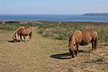
 Shetland ponies above Western Cove, Portreath - geograph.org.uk - 5247189.jpg 5,184 × 2,920; 4.97 MB
-
 Sign and entrance for holiday park, Porthtowan - geograph.org.uk - 4874434.jpg 1,600 × 1,201; 321 KB
-

-
 St Agnes Head from Portreath (6429).jpg 4,288 × 2,848; 5.32 MB
-

-
 Steps on the coastal path at Hayle Ulla - geograph.org.uk - 1863346.jpg 480 × 640; 117 KB
-
 Stone built cap on a mining ventilation shaft - geograph.org.uk - 6277714.jpg 1,024 × 768; 658 KB
-
 Structure east of Sally's Bottom (6388).jpg 4,288 × 2,848; 4.74 MB
-
 Structure east of Sally's Bottom (6392).jpg 4,288 × 2,848; 4.76 MB
-
 Structure east of Sally's Bottom (6393).jpg 2,848 × 4,288; 4.53 MB
-
 Structure east of Sally's Bottom (6395).jpg 4,288 × 2,848; 6.34 MB
-

-
 SW Coast Path, looking east - geograph.org.uk - 3203920.jpg 979 × 734; 313 KB
-
 Swallows in Portreath (6425).jpg 4,288 × 2,848; 4.32 MB
-
 Swallows in Portreath (6426).jpg 4,288 × 2,848; 4.3 MB
-
 The Bike Barn - geograph.org.uk - 3190129.jpg 1,142 × 857; 406 KB
-
 The capped top of Kite's Shaft - geograph.org.uk - 3205011.jpg 1,142 × 857; 346 KB
-
 The eroded cliffs north of Portreath - geograph.org.uk - 996652.jpg 640 × 480; 113 KB
-
 The Lower Pilots Lookout - geograph.org.uk - 3205980.jpg 857 × 1,142; 343 KB
-
 The offshore rock of Diamond - geograph.org.uk - 3203912.jpg 734 × 979; 309 KB
-
 The Pirates of Portreath - geograph.org.uk - 1838859.jpg 480 × 640; 100 KB
-
 The road to Portreath Airfield. - geograph.org.uk - 1886422.jpg 640 × 480; 126 KB
-
 The south side of Gooden Heane Point - geograph.org.uk - 3203905.jpg 979 × 734; 320 KB
-
 The South West Coast Path on Western Hill - geograph.org.uk - 6267892.jpg 1,005 × 754; 796 KB
-
 Tobban Horse - geograph.org.uk - 2006032.jpg 2,304 × 3,072; 2.29 MB
-

-
 Valley above Hayle Ulla (6411).jpg 4,288 × 2,848; 6.49 MB
-
 Victorian wallbox at Cambrose - geograph.org.uk - 3203892.jpg 734 × 979; 415 KB
-
 View over a wet Portreath - geograph.org.uk - 3111347.jpg 640 × 427; 56 KB
-
 View over Portreath - geograph.org.uk - 2861595.jpg 640 × 426; 55 KB
-
 View to Diamond Rock - geograph.org.uk - 2006022.jpg 3,072 × 2,304; 2.2 MB
-

-
 Wave breaking over the pier at Portreath - geograph.org.uk - 3824273.jpg 1,536 × 1,152; 1.09 MB
-
 Western Cove - geograph.org.uk - 1850286.jpg 640 × 480; 72 KB
-
 Western Cove - geograph.org.uk - 1850294.jpg 640 × 480; 83 KB
-
 Winter sun in Portreath - geograph.org.uk - 3804705.jpg 1,024 × 680; 136 KB
-
 Wipe out^ - geograph.org.uk - 3702186.jpg 1,024 × 843; 159 KB
-
 You have to go down, to get back up - geograph.org.uk - 3203911.jpg 1,077 × 808; 289 KB
-
 Barley Field - geograph.org.uk - 187252.jpg 640 × 427; 123 KB
-
 Fishing Cove - geograph.org.uk - 337031.jpg 477 × 640; 93 KB
-
 Gooden Heane Point - geograph.org.uk - 187777.jpg 640 × 427; 160 KB
-
 Gorse Burn on the Clifftop - geograph.org.uk - 472218.jpg 640 × 427; 142 KB
-
 Hayle Ulla, a forgotten valley - geograph.org.uk - 472246.jpg 427 × 640; 129 KB
-
 Houses on the hill above Portreath - geograph.org.uk - 188882.jpg 640 × 427; 101 KB
-
 Late Thrift - geograph.org.uk - 472233.jpg 640 × 427; 143 KB
-
 On the Ridge Between Two Steep Valleys - geograph.org.uk - 189787.jpg 640 × 427; 138 KB
-
 Ponies Grazing the Coastal Heath - geograph.org.uk - 317948.jpg 640 × 426; 93 KB
-
 Ralphs Cupboard - geograph.org.uk - 23491.jpg 640 × 479; 112 KB
-
 The old coast path behind Western Hill - geograph.org.uk - 317938.jpg 640 × 480; 100 KB
-
 Western Cove - geograph.org.uk - 317959.jpg 640 × 474; 117 KB


.jpg)


.jpg)
.jpg)


.jpg)


.jpg)
.jpg)
.jpg)


.jpg)


.jpg)
.jpg)


.jpg)


.jpg)


.jpg)


.jpg)
.jpg)
.jpg)
.jpg)


.jpg)
.jpg)


.jpg)


