Category:Ponte de Vila Formosa
Jump to navigation
Jump to search
| Object location | | View all coordinates using: OpenStreetMap |
|---|
bridge in Portugal  .jpg) | |||||
| Upload media | |||||
| Instance of | |||||
|---|---|---|---|---|---|
| Location | Lusitania, Hispania, Iberian Peninsula, Europe, Northern Hemisphere | ||||
| Carries | |||||
| Heritage designation | |||||
| Inception |
| ||||
| Length |
| ||||
 | |||||
|
This monument is classified as
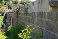
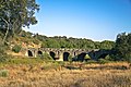
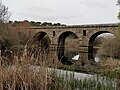
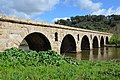
Monumento Nacional .It is indexed in the IGESPAR database ( Instituto de Gestão do Património Arquitectónico e Arqueológico ), under the reference 70180.It is indexed in the SIPA database (Sistema de Informação para o Património Arquitectónico) under the reference 4947. |
Media in category "Ponte de Vila Formosa"
The following 24 files are in this category, out of 24 total.
-
 1st Century Vila Formosa Roman Bridge - Apr 2011.jpg 4,288 × 2,848; 5.35 MB
-
 1st Century Vila Formosa Roman Bridge - Reverse Side - Apr 2011.jpg 4,288 × 2,848; 5.07 MB
-
 1st Century Vila Formosa Roman Bridge-2 - Apr 2011.jpg 4,288 × 2,848; 6.73 MB
-
 A ponte romana de Vila Formosa (531294820).jpg 1,100 × 380; 83 KB
-
 Ponte da Vila Formosa - Portugal (7658012560).jpg 1,366 × 2,048; 625 KB
-
 Ponte de Vila Formosa (52974652570).jpg 3,024 × 4,032; 9.86 MB
-
 Ponte de Vila Formosa - panoramio.jpg 793 × 517; 75 KB
-
 Ponte de Vila Formosa.jpg 4,928 × 3,264; 2.53 MB
-
 Ponte Romana da Vila Formosa - Portugal (4184531244).jpg 7,776 × 5,184; 10.5 MB
-
 Ponte Romana de Vila Formosa - Portugal (3845814356).jpg 7,776 × 5,184; 11.39 MB
-
 Ponte Romana de Vila Formosa - Portugal (3900773845).jpg 7,776 × 5,184; 15.25 MB
-
 PonteVilaFormosa.jpg 4,608 × 3,456; 5.59 MB
-
 Roman Bridge, Ponte da Vila Formosa, Lusitania, Portugal (12748924913).jpg 4,928 × 3,264; 11.21 MB
-
 Roman Bridge, Ponte da Vila Formosa, Lusitania, Portugal (12749223944).jpg 4,813 × 3,197; 8.59 MB
-
 Roman Bridge, Ponte da Vila Formosa, Lusitania, Portugal (12749248244).jpg 4,803 × 3,186; 10.82 MB
-
 Roman Bridge, Ponte da Vila Formosa, Lusitania, Portugal (12771926535).jpg 4,813 × 3,187; 8.45 MB
-
 Roman Bridge, Ponte da Vila Formosa, Lusitania, Portugal (12772064193).jpg 4,928 × 3,264; 13.49 MB
-
 Seda - Ponte de Vila Formosa - 20200827092304.jpg 3,968 × 2,976; 7.7 MB
-
 Seda - Ponte de Vila Formosa - 20200827092525.jpg 4,608 × 3,456; 4.92 MB
-
 Seda - Ponte de Vila Formosa - 20200827092704.jpg 4,608 × 3,456; 4.86 MB
-
 Seda - Ponte de Vila Formosa - 20200827093449.jpg 3,968 × 2,976; 5.85 MB
-
 Seda - Ponte de Vila Formosa - 20200827093852.jpg 3,968 × 2,976; 5.47 MB
-
 Seda - Ponte de Vila Formosa - 20200827100456.jpg 4,608 × 3,456; 3.92 MB
-
 Seda - Ponte de Vila Formosa - 20200827100620.jpg 4,608 × 3,456; 4.89 MB


.jpg)

.jpg)
.jpg)
.jpg)

.jpg)
.jpg)
.jpg)
.jpg)
.jpg)


.jpg)
Categories:
- Monumentos Nacionais in Portalegre (district)
- Classified monuments in Alter do Chão
- Alter do Chão
- Bridges in Portalegre (district)
- Ancient Roman bridges in Portugal
- 1st-century bridges
- Ribeira de Seda
- Lusitania
- Bridges in Portugal classified as Monumento Nacional
- Bridges in Portugal by name
- Bridges with 6 spans