Category:Ponte Internacional do Rio Águeda\Puente Internacional del Río Águeda
Jump to navigation
Jump to search
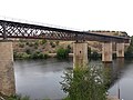
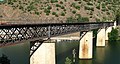
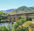
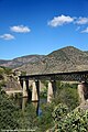
English: Águeda river Internacional railway bridge
Español: Puente Internacional del Río Águeda
Português: Ponte Internacional do Rio Águeda
| Object location | | View all coordinates using: OpenStreetMap |
|---|
railway bridge over river Águeda, between Portugal and Spain .jpg) | |||||
| Upload media | |||||
| Instance of | |||||
|---|---|---|---|---|---|
| Part of | |||||
| Location |
| ||||
| Crosses | |||||
| Carries | |||||
 | |||||
Media in category "Ponte Internacional do Rio Águeda\Puente Internacional del Río Águeda"
The following 29 files are in this category, out of 29 total.
-
 20210913 152524 La Fregeneda.jpg 4,128 × 3,096; 7.39 MB
-
 20210913 153224 La Fregeneda.jpg 4,128 × 3,096; 5.4 MB
-
 Cruzeiro regua-barca d alva 311.jpg 1,600 × 1,200; 456 KB
-
 España, ou será Portugal? (3776325072).jpg 1,280 × 677; 778 KB
-
 Hey! Isto é português! (3775517773).jpg 1,278 × 679; 858 KB
-

-
 O verdadeiro fim (3775520669).jpg 1,280 × 677; 766 KB
-
 Peligro! (3775518813).jpg 1,278 × 677; 886 KB
-
 Ponte Internacional do rio Agueda - Os Caminhos de Ferro Portugueses 1856-2006.jpg 4,565 × 3,269; 5.83 MB
-
 Ponte Internacional do Águeda (3776322810).jpg 1,280 × 679; 864 KB
-
 Ponte Internacional sobre o Agueda DSC0168w (cropped).jpg 874 × 602; 151 KB
-
 Puente internacional del ferrocarril de La Fregeneda (España).jpg 500 × 453; 370 KB
-
 Puente Internacional sobre río Agueda,La Fregeneda, Salamanca - panoramio.jpg 1,500 × 1,000; 1.42 MB
-
 Rio Douro em Portugal DSC01203 (15713566861).jpg 4,912 × 3,264; 6.47 MB
-
 Rio Douro em Portugal DSC01221 (15531293277).jpg 4,912 × 3,264; 5.69 MB
-
 Rio Douro em Portugal DSC01227 (15717987502).jpg 4,912 × 3,264; 7.03 MB
-
 Rio Douro em Portugal DSC01228 (15716424755).jpg 4,912 × 3,264; 6.19 MB
-
 Rio Douro em Portugal DSC01246 (15530840188).jpg 4,912 × 3,264; 6.94 MB
-
 Rio Douro em Portugal DSC01249 (15530373709).jpg 4,912 × 3,264; 6.44 MB
-
 Rio Douro em Portugal DSC01250 (15716233275).jpg 4,912 × 3,264; 7.06 MB
-
 Rio Douro em Portugal DSC01251 (15531390240).jpg 3,264 × 4,912; 9.06 MB
-
 Rio Águeda - Portugal (21160375290).jpg 3,861 × 2,552; 1.51 MB
-
 Rio Águeda - Portugal (22272048068).jpg 2,526 × 3,790; 2.22 MB
-
 Rio Águeda - Portugal (22272912089).jpg 2,552 × 3,828; 2.36 MB
-
 Rio Águeda - Portugal (22433719866).jpg 3,888 × 2,315; 1.39 MB
-
 Rio Águeda - Portugal (23303815499).jpg 3,888 × 2,537; 1.95 MB
-
 Rio Águeda - Portugal (23563219382).jpg 3,858 × 2,572; 1.45 MB
-
 Rio Águeda - Portugal (25508645442).jpg 3,805 × 2,434; 1.99 MB
-
 Río Águeda 01.jpg 4,288 × 2,848; 8.69 MB


.jpg)
.jpg)
.jpg)
.jpg)
.jpg)

.jpg)
.jpg)

.jpg)
.jpg)
.jpg)
.jpg)
.jpg)
.jpg)
.jpg)
.jpg)
.jpg)
.jpg)
.jpg)
.jpg)
.jpg)
.jpg)
.jpg)

Categories:
- International railway line between Barca d'Alva-La Fregeneda and La Fuente de San Esteban
- Iron truss railway bridges in Portugal
- Barca d'Alva
- Bridges between Portugal and Spain
- Águeda River
- Linha do Douro
- Former railway bridges in Portugal
- Bridges in Portugal by name
- Bridges in Guarda (district)
- Visitor attractions in Arribes del Duero Natural Park
- Visitor attractions in Parque Natural do Douro Internacional