Category:Ponga
Jump to navigation
Jump to search
Municipalities in Asturias: Allande · Aller · Amieva · Avilés · Belmonte de Miranda · Bimenes · Boal · Cabrales · Cabranes · Candamo · Cangas de Onís · Cangas del Narcea · Caravia · Carreño · Caso · Castrillón · Castropol · Coaña · Colunga · Corvera · Cudillero · Degaña · El Franco · El Valle Altu de Peñamellera · Gijón · Gozón · Grado · Grandas de Salime · Ibias · Illano · Illas · Langreo · Laviana · Lena · Llanera · Llanes · Mieres · Morcín · Muros de Nalón · Nava · Navia · Noreña · Onís · Oviedo · Parres · Pesoz · Peñamellera Baja · Piloña · Ponga · Pravia · Proaza · Quirós · Las Regueras · Ribadedeva · Ribadesella · Ribera de Arriba · Riosa · Salas · San Martín de Oscos · San Martín del Rey Aurelio · San Tirso de Abres · Santa Eulalia de Oscos · Santo Adriano · Sariego · Siero · Sobrescobio · Somiedo · Soto del Barco · Tapia de Casariego · Taramundi · Teverga · Tineo · Valdés · Vegadeo · Villanueva de Oscos · Villaviciosa · Villayón · Yernes y Tameza ·
municipality (concejo) in Asturias, Spain | |||||
| Upload media | |||||
| Instance of | |||||
|---|---|---|---|---|---|
| Location | Province of Asturias, Asturias, Spain | ||||
| Capital | |||||
| Head of government |
| ||||
| Population |
| ||||
| Area |
| ||||
| Elevation above sea level |
| ||||
| official website | |||||
 | |||||


Media in category "Ponga"
The following 38 files are in this category, out of 38 total.
-
 " Otoño en el Bosque de Peloñu " , Ponga , Asturias - panoramio.jpg 3,000 × 4,000; 2.67 MB
-
 "Entalladura fantástica" - panoramio.jpg 4,288 × 2,848; 9.98 MB
-
 "Plateros" - panoramio.jpg 4,288 × 2,848; 9.61 MB
-
 Flag of ponga.png 375 × 250; 12 KB
-
 Alsophila tricolor 1.jpg 1,024 × 640; 477 KB
-
 Bandera de Ponga.svg 3,000 × 2,000; 742 KB
-
 Beleño.jpg 4,000 × 3,000; 3.92 MB
-
 Cerca y cresta - panoramio.jpg 4,288 × 2,848; 8.47 MB
-
 Desfiladero de los beyos 01.jpg 1,024 × 768; 671 KB
-
 Desfiladero de los Beyos 02.jpg 1,944 × 2,592; 730 KB
-
 Escudo de Ponga.gif 202 × 350; 7 KB
-
 Escudo de Ponga.svg 515 × 936; 636 KB
-
 Foz de la Porquera, Ponga, Asturias 1.jpg 3,776 × 2,520; 4.1 MB
-
 Iglesia Parroquial San Ignacio de Los Beyos.jpg 1,063 × 709; 705 KB
-
 IMG-20180917-WA0005.jpg 1,200 × 1,600; 447 KB
-
 IMG-20180917-WA0008.jpg 900 × 1,600; 215 KB
-
 IMG-20180917-WA0041.jpg 900 × 1,600; 161 KB
-
 IMG-20180921-WA000.jpg 900 × 1,600; 101 KB
-
 IMG-20180922-WA003.jpg 1,600 × 900; 184 KB
-
 IMG-20180922-WA0039.jpg 900 × 1,600; 116 KB
-
 Karte Gemeinde Ponga 2022.png 2,999 × 1,804; 622 KB
-
 Mirador de la Collada , Amieva. - panoramio.jpg 4,000 × 3,000; 2.61 MB
-
 MTN25-0055c1-1994-Sames.jpg 7,775 × 5,512; 8.71 MB
-
 MTN25-0055c1-2002-Sames.jpg 7,775 × 5,512; 12.37 MB
-
 MTN25-0055c1-2009-Sames.jpg 7,874 × 5,161; 12.25 MB
-
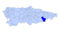
 Ponga (situación).jpg 750 × 350; 50 KB
-
 Ponga Asturies map.svg 778 × 413; 292 KB
-
 Ponga desde Sedo del Toyu-PN de Ponga-Asturias-Spain.jpg 4,000 × 3,000; 4.35 MB
-
 Ponga, Asturias.jpg 6,000 × 3,368; 1.95 MB
-
 Ponga.png 454 × 181; 6 KB
-
 Ponga1.jpg 1,878 × 1,562; 775 KB
-
 Ponga2.jpg 2,816 × 2,112; 1.95 MB
-
 Por allí abajo corre el Milu - panoramio.jpg 4,288 × 2,848; 8.9 MB
-
 Santa María de VIEGU - panoramio.jpg 4,288 × 2,848; 8.08 MB
-
 Sedo del Toyu-Parque Natural de Ponga-Asturias-Spain.jpg 4,000 × 3,000; 4.04 MB
-
 Viboli en el valle-PNatural de Ponga-Asturias-Spain.jpg 4,000 × 3,000; 4.2 MB
-
 Vista a la Mota de Cetin bajando para la Collada de Moandi - panoramio.jpg 4,000 × 3,000; 2.55 MB
-
 Vista de Cazu desde la carretera AS - 339 . - panoramio.jpg 4,000 × 3,000; 2.69 MB


.jpg)


