Category:Pomponrahka
Jump to navigation
Jump to search
Suomi: Pomponrahka on Turussa Lentokentän kaupunginosassa Turun lentoaseman eteläpuolella, Kuninkojan latvoilla sijaitseva suoalue. Alue on natura 2000 -aluetta 135 hehtaarin laajudelta ja kuuluu valtakunnalliseen soidensuojeluohjelmaan.
Svenska: Pomponrahka är ett naturskyddsområde i Åbo. Det ingår i det nationella myrskyddsprogrammet och i Natura 2000. Området ligger mellan stadsbebyggelsen och flygfältet, och består av Isosuo i norr och Pomponrahka i söder. Arealen är 75–135 hektar. Kungsbäcken (finska: Kuninkoja) har sina källor i området.
English: Pomponrahka became protected under the Nature Conservation Act in 1983 and it is part of a national mire protection programme. The mire complex, approximately 70 hectares in area, consists of the Isosuo-bog located further North, and Pomponrahka-bog further south. Pomponrahka is located in the south-west of Finland, city of Turku.
| Upload media | |||||
| Instance of |
| ||||
|---|---|---|---|---|---|
| Location | Turku, Southwest Finland, South-Western Finland Regional State Administrative Agency, Finland | ||||
 | |||||
Media in category "Pomponrahka"
The following 23 files are in this category, out of 23 total.
-
 Hjortronblomma Pomponrahka med fjäril och fluga.jpg 2,144 × 1,608; 1.93 MB
-
 Hjortronblomma Pomponrahka med fjäril.jpg 2,144 × 1,608; 1.73 MB
-
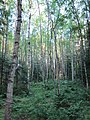 Laajaa koivikkoaluetta, Pomponrahka, Turku, 11.7.2010..JPG 2,736 × 3,648; 3.93 MB
-
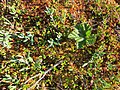 Lakka ja karpalo, Pomponrahka (Isosuo), Turku, 11.7.2010..JPG 3,648 × 2,736; 4.11 MB
-
 Oja, Pomponrahka, Turku, 11.7.2010..JPG 2,736 × 3,648; 3.98 MB
-
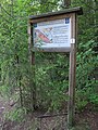 Opastaulu, Pomponrahka, Turku, 11.7.2010..JPG 2,736 × 3,648; 3.78 MB
-
 Pitkospuita, Pomponrahka (Isosuo), Turku, 11.7.2010 (3).JPG 3,648 × 2,736; 3.93 MB
-
 Pitkospuita, Pomponrahka (Isosuo), Turku, 11.7.2010 (6).JPG 3,648 × 2,736; 4.03 MB
-
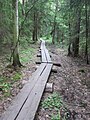 Pitkospuita, Pomponrahka, 11.7.2010 (2).JPG 2,736 × 3,648; 3.67 MB
-
 Pitkospuita, Pomponrahka, 11.7.2010.JPG 3,648 × 2,736; 3.66 MB
-
 Pomponrahka (Isosuo), Turku, 11.7.2010 (2).JPG 3,648 × 2,736; 3.33 MB
-
 Pomponrahka (Isosuo), Turku, 11.7.2010 (3).JPG 3,648 × 2,736; 3.29 MB
-
 Pomponrahka (Isosuo), Turku, 11.7.2010.JPG 3,648 × 2,736; 2.96 MB
-
 Pomponrahka (Isosuo, Rajakallio), Turku, 11.7.2010..JPG 3,648 × 2,736; 4.07 MB
-
 Pyöreälehtikihokki, Pomponrahka (Isosuo), Turku, 11.7.2010 (2).JPG 2,736 × 3,648; 2.01 MB
-
 Pyöreälehtikihokki, Pomponrahka (Isosuo), Turku, 11.7.2010.JPG 2,736 × 3,648; 3.04 MB
-
 Sinisiipi sp, Pomponrahka (Isosuo), Turku, 11.7.2010 (2).JPG 3,648 × 2,736; 2.05 MB
-
 Sinisiipi sp, Pomponrahka (Isosuo), Turku, 11.7.2010 (3).JPG 3,648 × 2,736; 2.04 MB
-
 Sinisiipi sp, Pomponrahka (Isosuo), Turku, 11.7.2010 (4).JPG 3,648 × 2,736; 2.02 MB
-
 Sinisiipi sp, Pomponrahka (Isosuo), Turku, 11.7.2010.JPG 3,648 × 2,736; 3.22 MB
-
 Tupasvilla, Pomponrahka (Isosuo), Turku, 11.7.2010..JPG 2,736 × 3,648; 4.39 MB
-
 Vaivaiskoivu, Pomponrahka (Isosuo), Turku, 11.7.2010 (2).JPG 2,736 × 3,648; 2.23 MB
-
 Vaivaiskoivu, Pomponrahka (Isosuo), Turku, 11.7.2010.JPG 2,736 × 3,648; 4.06 MB


,_Turku,_11.7.2010..JPG)


,_Turku,_11.7.2010_(3).JPG)
,_Turku,_11.7.2010_(6).JPG)
.JPG)

,_Turku,_11.7.2010_(2).JPG)
,_Turku,_11.7.2010_(3).JPG)
,_Turku,_11.7.2010.JPG)
,_Turku,_11.7.2010..JPG)
,_Turku,_11.7.2010_(2).JPG)
,_Turku,_11.7.2010.JPG)
,_Turku,_11.7.2010_(2).JPG)
,_Turku,_11.7.2010_(3).JPG)
,_Turku,_11.7.2010_(4).JPG)
,_Turku,_11.7.2010.JPG)
,_Turku,_11.7.2010..JPG)
,_Turku,_11.7.2010_(2).JPG)
,_Turku,_11.7.2010.JPG)