Category:Political maps of Mercer County, Ohio as of the 2000 United States Census
Jump to navigation
Jump to search
Media in category "Political maps of Mercer County, Ohio as of the 2000 United States Census"
The following 26 files are in this category, out of 26 total.
-
 Map of Mercer County Ohio Highlighting Black Creek Township.png 396 × 614; 21 KB
-
 Map of Mercer County Ohio Highlighting Burkettsville Village.png 396 × 614; 21 KB
-
 Map of Mercer County Ohio Highlighting Butler Township.png 396 × 614; 21 KB
-
 Map of Mercer County Ohio Highlighting Celina City.png 396 × 614; 21 KB
-
 Map of Mercer County Ohio Highlighting Center Township.png 396 × 614; 21 KB
-
 Map of Mercer County Ohio Highlighting Chickasaw Village.png 396 × 614; 21 KB
-
 Map of Mercer County Ohio Highlighting Coldwater Village.png 396 × 614; 21 KB
-
 Map of Mercer County Ohio Highlighting Dublin Township.png 396 × 614; 21 KB
-
 Map of Mercer County Ohio Highlighting Fort Recovery Village.png 396 × 614; 21 KB
-
 Map of Mercer County Ohio Highlighting Franklin Township.png 396 × 614; 21 KB
-
 Map of Mercer County Ohio Highlighting Gibson Township.png 396 × 614; 21 KB
-
 Map of Mercer County Ohio Highlighting Granville Township.png 396 × 614; 21 KB
-
 Map of Mercer County Ohio Highlighting Hopewell Township.png 396 × 614; 21 KB
-
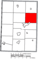
 Map of Mercer County Ohio Highlighting Jefferson Township.png 396 × 614; 21 KB
-
 Map of Mercer County Ohio Highlighting Liberty Township.png 396 × 614; 21 KB
-
 Map of Mercer County Ohio Highlighting Marion Township.png 396 × 614; 21 KB
-
 Map of Mercer County Ohio Highlighting Mendon Village.png 396 × 614; 21 KB
-
 Map of Mercer County Ohio Highlighting Montezuma Village.png 396 × 614; 21 KB
-
 Map of Mercer County Ohio Highlighting Recovery Township.png 396 × 614; 21 KB
-
 Map of Mercer County Ohio Highlighting Rockford Village.png 396 × 614; 21 KB
-
 Map of Mercer County Ohio Highlighting Saint Henry Village.png 396 × 614; 21 KB
-
 Map of Mercer County Ohio Highlighting Union Township.png 396 × 614; 21 KB
-
 Map of Mercer County Ohio Highlighting Washington Township.png 396 × 614; 21 KB
-
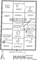 Map of Mercer County Ohio With Municipal and Township Labels.PNG 396 × 643; 39 KB
-
 Map of Mercer County, Ohio No Text, Municipalities Distinct.png 396 × 614; 21 KB
-
 Map of Mercer County, Ohio No Text.png 396 × 643; 21 KB


