Category:Point Montara Lighthouse
Jump to navigation
Jump to search
| Object location | | View all coordinates using: OpenStreetMap |
|---|
|
This is a category about a place or building that is listed on the National Register of Historic Places in the United States of America. Its reference number is 91001094. |
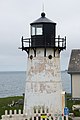
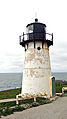
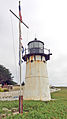
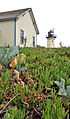
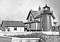
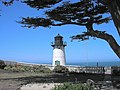
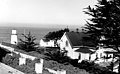
English: Point Montara Light. The present tower was built in 1881 and was originally installed at Mayo's Beach on Cape Cod. When that station was deactivated in 1922, the tower was dismantled and shipped to the west coast where it was re-erected at the Point Montara Light Station in 1928.
lighthouse in California, United States .jpg) | |||||
| Upload media | |||||
| Instance of | |||||
|---|---|---|---|---|---|
| Made from material | |||||
| Location | San Mateo County, California, Pacific States Region | ||||
| Located in or next to body of water | |||||
| Heritage designation | |||||
| Service entry |
| ||||
| Inception |
| ||||
| Height |
| ||||
 | |||||
Media in category "Point Montara Lighthouse"
The following 34 files are in this category, out of 34 total.
-
 California Trip - June 2016 - Point Montara Lighthouse (28678590984).jpg 6,000 × 4,000; 17.77 MB
-
 California Trip - June 2016 - Point Montara Lighthouse (28859430030).jpg 5,773 × 3,849; 12.64 MB
-
 California Trip - June 2016 - Point Montara Lighthouse (29069105111).jpg 4,000 × 6,000; 13.36 MB
-
 California Trip - June 2016 - Point Montara Lighthouse (29069115971).jpg 3,874 × 5,811; 9.68 MB
-
 California Trip - June 2016 - Point Montara Lighthouse (29146747575).jpg 6,000 × 4,000; 18.68 MB
-
 California Trip - June 2016 - Point Montara Lighthouse (29146753675).jpg 3,911 × 5,866; 11.91 MB
-
 California-05757 - Point Montara Lighthouse (20611352136).jpg 1,080 × 1,920; 1.36 MB
-
 California-05758 - Point Montana Lighthouse Lantern (20449611650).jpg 1,114 × 1,939; 985 KB
-
 California-05761 - Point Montara Lighthouse (20016694423).jpg 1,080 × 1,920; 1.36 MB
-
 California-05762 - Point Montara Lighthouse (20644271341).jpg 1,989 × 1,202; 1.33 MB
-
 California-05763 - Point Montara Lighthouse (20637610625).jpg 1,080 × 1,920; 1.45 MB
-
 California-05765 - Hostel & Lighthouse (20628495302).jpg 1,939 × 1,114; 1.74 MB
-
 California-05766 - Point Montara Lighthouse (20015066514).jpg 1,147 × 1,957; 1.49 MB
-
 California-05767 - Point Montara Lighthouse (20628500532).jpg 1,080 × 1,920; 1.63 MB
-
 Lighthouse (California) (17271661722).jpg 1,000 × 667; 491 KB
-
 Lighthouse California-05758 - Point Montana Lighthouse Lantern (20449611650).jpg 1,114 × 1,939; 990 KB
-
 Mayo Beach Light 1915.jpg 700 × 498; 292 KB
-
 Point Montara Light (2013).jpg 5,086 × 3,313; 10.9 MB
-
 Point Montara Light (8646632093).jpg 5,086 × 3,313; 10.85 MB
-
 Point Montara Light - Montara CA.jpg 3,648 × 2,736; 5.18 MB
-
 Point Montara Light Station, CA 1, Montara, CA 10-30-2011 10-32-14 AM.JPG 3,072 × 2,304; 1.58 MB
-
 Point Montara Light Station, CA 1, Montara, CA 10-30-2011 10-33-13 AM.JPG 2,304 × 3,072; 1.48 MB
-
 Point Montara Light Station, CA 1, Montara, CA 10-30-2011 11-00-14 AM.JPG 3,072 × 2,304; 1.3 MB
-
 Point Montara Light Station, CA 1, Montara, CA 10-30-2011 11-04-14 AM.JPG 2,304 × 3,072; 1.37 MB
-
 Point Montara Light Station.tif 1,500 × 539; 3.09 MB
-

-
 Point Montara Lighthouse North.jpg 3,414 × 2,561; 2.28 MB
-
 Point Montara Lighthouse South.jpg 3,131 × 2,208; 1.73 MB
-
 Point Montara Lighthouse, Montara, California LCCN2011630359.tif 4,500 × 3,533; 91 MB
-
 Point Montara Lighthouse, the "lost" lighthouse from Cape Cod, Massachusetts.jpg 3,264 × 2,448; 1.42 MB
-
 Point Montara Lighthouse.jpg 720 × 480; 97 KB
-
 Point Montara Panorama.jpg 5,885 × 2,567; 3.82 MB
-
 Point Montara sm.jpg 500 × 374; 63 KB
-
 USCGpointmontara.JPG 462 × 286; 44 KB
.jpg)
.jpg)
.jpg)
.jpg)
.jpg)
.jpg)
.jpg)
.jpg)
.jpg)
.jpg)
.jpg)
.jpg)
.jpg)
.jpg)
_(17271661722).jpg)
.jpg)

.jpg)


Categories:
- Lighthouses in the United States by name
- National Register of Historic Places in San Mateo County, California
- Lighthouses built in 1881
- Lighthouses built in 1928
- Steel lighthouses in the United States
- Relocated lighthouses
- Lighthouses with fourth order Fresnel lenses
- Lighthouses on the National Register of Historic Places in California
- Lighthouses in San Mateo County, California
- Lighthouses of the Pacific Ocean
- White lighthouses in the United States
- California Points of Historical Interest
- Lighthouses by range, 10 to 14 nm
- 9-meter-tall structures in the United States
- Lighthouses by height, 1 to 10 meters