Category:Plum Island (New York)
Jump to navigation
Jump to search
island in the United States of America  | |||||
| Upload media | |||||
| Instance of | |||||
|---|---|---|---|---|---|
| Location | Suffolk County, New York | ||||
| Located in or next to body of water | |||||
| Width |
| ||||
| Length |
| ||||
| Population |
| ||||
| Area |
| ||||
 | |||||
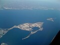
English: Plum Island is an island in the town of Southold in Suffolk County, New York. The island is situated in Gardiners Bay of the Long Island Sound, east of Orient Point, off the eastern end of the North Fork coast of Long Island. It is about 3 miles (4.8 km) long and 1 mile (1.6 km) wide at its widest point. The island is the site of the Plum Island Animal Disease Center (PIADC), which was established by the United States Department of Agriculture (USDA) in 1954. The Island is also the site of the former U.S. military installation Fort Terry (c. 1897), and the historic Plum Island Light (c. 1869), and its automated replacement. Congress voted in December 2020 to block the proposed sale of Plum Island sale and preserve it. In 2020, President Donald Trump signed the legislation.
Subcategories
This category has the following 3 subcategories, out of 3 total.
M
- Maps of Plum Island (11 F)
P
Media in category "Plum Island (New York)"
The following 8 files are in this category, out of 8 total.
-
 Aerial view of Orient, Long Island, 2009-03-04.jpg 1,600 × 1,200; 209 KB
-
 Plum Island, aerial photograph.jpg 3,264 × 2,448; 3.18 MB
-
 Plumisland.png 3,264 × 2,448; 10.58 MB
-
 Spider Crabs (23917683992).jpg 2,560 × 1,920; 2.65 MB
-
 T56-2.jpg 5,245 × 3,463; 5.12 MB
-
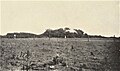 The American botanist - a monthly journal for the plant lover (1913) (17490420913).jpg 2,530 × 1,498; 1.46 MB
-
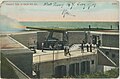 Vintage colorized postcard of 10-inch cannon firing at Fort Terry, N.Y.jpg 2,177 × 1,427; 1.05 MB
-
 Vintage colorized postcard View of Fort Terry, N.Y.jpg 2,163 × 1,376; 1,022 KB


.jpg)

_(17490420913).jpg)

